Fraud Blocker Skip to main content

Countries Collection (page 2)

"The King of Kings: A glimpse into the diverse tapestry throughout history" Daily Mail War Map, WW1: Unveiling the global impact of nations during the Great War

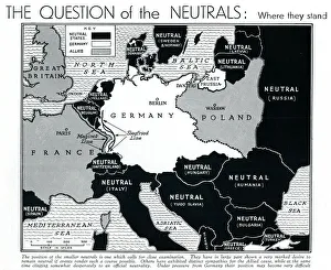
Background imageCountries Collection: Map of Europe showing WW2 alliances, September 1939

Map of Europe showing WW2 alliances, September 1939
A map of Europe, colour-coded to represent the different alliances between nations shortly after the outbreak of war, September 1939

Plan of Versailles, France in 1789. From Historical Atlas, published 1923 (print)
2603518 Plan of Versailles, France in 1789. From Historical Atlas, published 1923 (print).

Background imageCountries Collection: Map showing the eastern area of the great war (litho)

Map showing the eastern area of the great war (litho)
3252865 Map showing the eastern area of the great war (litho); Private Collection; (add.info.: Map showing the eastern area of the great war)

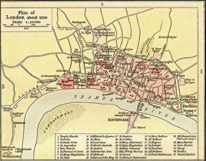
Background imageCountries Collection: Plan of London, England c. 1300. From Historical Atlas, published 1923

Plan of London, England c. 1300. From Historical Atlas, published 1923
2603529 Plan of London, England c. 1300. From Historical Atlas, published 1923..

Background imageCountries Collection: An early Hindu system of the universe

An early Hindu system of the universe
3732380 An early Hindu system of the universe; (add.info.: Illustration depicting an early Hindu system of the universe. The abode of the Gods, Meru, is in the centre of the lotus flower)

Background imageCountries Collection: Map of Napoleon's Empire in 1812. From The Story of England, published 1930

Map of Napoleon's Empire in 1812. From The Story of England, published 1930
3058424 Map of Napoleon's Empire in 1812. From The Story of England, published 1930.; Photo © Hilary Morgan.

Background imageCountries Collection: Map of the British Empire in 1901. From A First Book of British History published 1925

Map of the British Empire in 1901. From A First Book of British History published 1925
3058527 Map of the British Empire in 1901. From A First Book of British History published 1925.; Photo © Hilary Morgan.

Background imageCountries Collection: Map of Rome and Carthage at the beginning of the Second Punic War, 218 BC, publ. 1923 (colour litho)

Map of Rome and Carthage at the beginning of the Second Punic War, 218 BC, publ. 1923 (colour litho)
2603515 Map of Rome and Carthage at the beginning of the Second Punic War, 218 BC, publ. 1923 (colour litho) by American School, (20th century); (add.info.: From Historical Atlas, published 1923.).

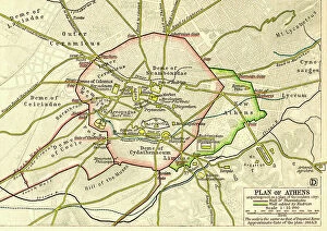
Background imageCountries Collection: Plan of Athens, Greece c.200 AD. From Historical Atlas, published 1923

Plan of Athens, Greece c.200 AD. From Historical Atlas, published 1923
2603507 Plan of Athens, Greece c.200 AD. From Historical Atlas, published 1923..

Background imageCountries Collection: Map of the Athenian Empire at its height, c.450 B.C. From Historical Atlas

Map of the Athenian Empire at its height, c.450 B.C. From Historical Atlas, published 1923 (colour litho)
2603503 Map of the Athenian Empire at its height, c.450 B.C. From Historical Atlas, published 1923 (colour litho) by American School, (20th century).

Background imageCountries Collection: Map of the Twelve Tribes of Israel, Canaan, or Palestine, as it was divided between the twelve

Map of the Twelve Tribes of Israel, Canaan, or Palestine, as it was divided between the twelve tribes of Israel
6117853 Map of the Twelve Tribes of Israel, Canaan, or Palestine, as it was divided between the twelve tribes of Israel. After a map published in 1750 (map); Photo © Ken Welsh

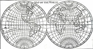
Background imageCountries Collection: 18th century map of the then-known world, 18th century

18th century map of the then-known world, 18th century
5309273 18th century map of the then-known world, 18th century; (add.info.: 18th century map of the then-known world. Dated 18th century); Universal History Archive/UIG.

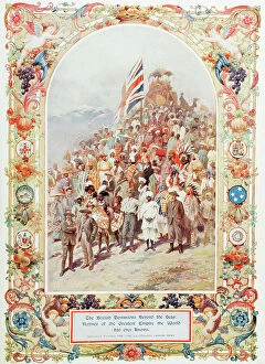
Background imageCountries Collection: Representatives of The British Dominions beyond the seas, in England for the coronation of George

Representatives of The British Dominions beyond the seas, in England for the coronation of George V, 1910
2915342 Representatives of The British Dominions beyond the seas, in England for the coronation of George V, 1910. From The Illustrated London News, 1910.; Photo © Hilary Morgan.

Background imageCountries Collection: Representatives of The British Dominions beyond the seas, in England for the coronation of George

Representatives of The British Dominions beyond the seas, in England for the coronation of George V, 1910
2915341 Representatives of The British Dominions beyond the seas, in England for the coronation of George V, 1910. From The Illustrated London News, 1910.; Photo © Hilary Morgan.

Background imageCountries Collection: The War Map of Western Europe showings the entire zone of military operations in the Western

The War Map of Western Europe showings the entire zone of military operations in the Western campaign (litho)
3252857 The War Map of Western Europe showings the entire zone of military operations in the Western campaign (litho); Private Collection; (add.info.: The War Map of Western Europe)

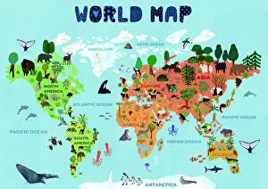
Background imageCountries Collection: World map for kids

World map for kids
Jota de jai

Background imageCountries Collection: Leo world map with countries

Leo world map with countries
Rosana Laiz Blursbyai

Background imageCountries Collection: 18th century map of Northern Europe and Spitsbergen, showing how much was still to be charted

18th century map of Northern Europe and Spitsbergen, showing how much was still to be charted, 18th century
5309274 18th century map of Northern Europe and Spitsbergen, showing how much was still to be charted, 18th century; (add.info.: 18th century map of Northern Europe and Spitsbergen)

Background imageCountries Collection: Map of Roman Britain c. 410. From Historical Atlas, published 1923 (print)

Map of Roman Britain c. 410. From Historical Atlas, published 1923 (print)
2603520 Map of Roman Britain c. 410. From Historical Atlas, published 1923 (print).

Background imageCountries Collection: Map of the Portuguese Colonial Dominions in India and the Malay Archipelago, 1498 -1580

Map of the Portuguese Colonial Dominions in India and the Malay Archipelago, 1498 -1580, 1923 (engraving)
2603519 Map of the Portuguese Colonial Dominions in India and the Malay Archipelago, 1498 -1580, 1923 (engraving); (add.info.: From Historical Atlas, published 1923.).

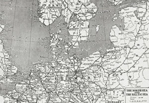
Background imageCountries Collection: Map showing the North sea and the Baltic sea at the time of the first world war (litho)

Map showing the North sea and the Baltic sea at the time of the first world war (litho)
3252859 Map showing the North sea and the Baltic sea at the time of the first world war (litho); Private Collection; (add.info)

Background imageCountries Collection: The Travels and Exploits of General Bonaparte in Various Countries. Napoleon Bonaparte (1760-1821)

The Travels and Exploits of General Bonaparte in Various Countries. Napoleon Bonaparte (1760-1821)
543787 The Travels and Exploits of General Bonaparte in Various Countries. Napoleon Bonaparte (1760-1821). French popular coloured engraving.; (add.info.: France)

Background imageCountries Collection: Russo-Japanese War 1904-1905: Japan as God of Peace stamping on Russian warship

Russo-Japanese War 1904-1905: Japan as God of Peace stamping on Russian warship
528348 Russo-Japanese War 1904-1905: Japan as God of Peace stamping on Russian warship and holding aloft Tsar Nicholas II holding white flag

Background imageCountries Collection: Map of the settlements of Angles, Saxons and Jutes in Britain c. 600 (print)

Map of the settlements of Angles, Saxons and Jutes in Britain c. 600 (print)
2603521 Map of the settlements of Angles, Saxons and Jutes in Britain c. 600 (print); (add.info.: From Historical Atlas, published 1923.).

Background imageCountries Collection: Map of Acadia, 17th century colony of New France in northeastern North America

Map of Acadia, 17th century colony of New France in northeastern North America, and the water highway to Canada
2603482 Map of Acadia, 17th century colony of New France in northeastern North America, and the water highway to Canada. From The History of Our Country, published 1899.

Background imageCountries Collection: Plan of an English mediaeval manor ddated 14th century (print)

Plan of an English mediaeval manor ddated 14th century (print)
2603530 Plan of an English mediaeval manor ddated 14th century (print); (add.info.: From Historical Atlas, published 1923.).

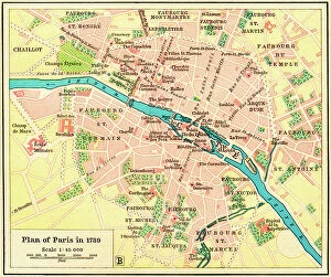
Background imageCountries Collection: Plan of Paris, France in 1789. From Historical Atlas, published 1923 (print)

Plan of Paris, France in 1789. From Historical Atlas, published 1923 (print)
2603517 Plan of Paris, France in 1789. From Historical Atlas, published 1923 (print).

Background imageCountries Collection: World map. Believed by some to have been compiled by Zheng He.Zheng He (1371-1435)or Cheng Ho

World map. Believed by some to have been compiled by Zheng He.Zheng He (1371-1435)or Cheng Ho
529404 World map. Believed by some to have been compiled by Zheng He.Zheng He (1371-1435)or Cheng Ho, China's most famous navigator

Background imageCountries Collection: Needing repair

Needing repair
Eden Antho

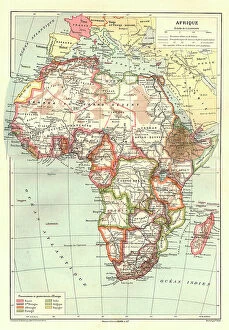
Background imageCountries Collection: 'Map of Afrique showing Possessions et protectorats d'Europe, 1914. Creator: Unknown

'Map of Afrique showing Possessions et protectorats d'Europe, 1914. Creator: Unknown
'Map of Afrique showing Possessions et protectorats d'Europe, 1914. From "Grande Geographie Bong Illustree", 1914

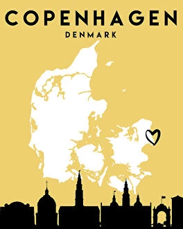
Background imageCountries Collection: City Love Maps 28

City Love Maps 28
Emiliano Deificus

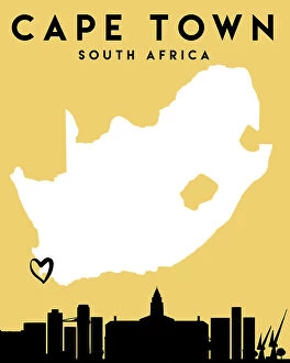
Background imageCountries Collection: City Love Maps 23

City Love Maps 23
Emiliano Deificus

Background imageCountries Collection: City Love Maps 33

City Love Maps 33
Emiliano Deificus

Background imageCountries Collection: City Love Maps 29

City Love Maps 29
Emiliano Deificus

Background imageCountries Collection: City Love Maps 03

City Love Maps 03
Emiliano Deificus

Background imageCountries Collection: City Love Maps 08

City Love Maps 08
Emiliano Deificus

Background imageCountries Collection: City Love Maps 30

City Love Maps 30
Emiliano Deificus

Background imageCountries Collection: City Love Maps 04

City Love Maps 04
Emiliano Deificus

Background imageCountries Collection: City Love Maps 06

City Love Maps 06
Emiliano Deificus

Background imageCountries Collection: City Love Maps 19

City Love Maps 19
Emiliano Deificus

Background imageCountries Collection: City Love Maps 14

City Love Maps 14
Emiliano Deificus

Background imageCountries Collection: City Love Maps 18

City Love Maps 18
Emiliano Deificus

Background imageCountries Collection: City Love Maps 27

City Love Maps 27
Emiliano Deificus

Background imageCountries Collection: City Love Maps 02

City Love Maps 02
Emiliano Deificus

Background imageCountries Collection: City Love Maps 17

City Love Maps 17
Emiliano Deificus

Background imageCountries Collection: City Love Maps 24

City Love Maps 24
Emiliano Deificus

Background imageCountries Collection: City Love Maps 25

City Love Maps 25
Emiliano Deificus

Background imageCountries Collection: City Love Maps 26

City Love Maps 26
Emiliano Deificus


All Professionally Made to Order for Quick Shipping

"The King of Kings: A glimpse into the diverse tapestry throughout history" Daily Mail War Map, WW1: Unveiling the global impact of nations during the Great War. Anglo-Saxon 10th century world map: Tracing the ancient roots and territorial boundaries of countries. UK at night from space: Witnessing the vibrant glow that illuminates a nation's cities under a starry sky. World War One Combatants - Map of Europe: Exploring the intricate alliances and conflicts between countries during this tumultuous era. Scotland, UK, satellite image: Marveling at Scotland's breathtaking landscapes as seen from above. Poster advertising Austro-Hungarian War Bonds: Reflecting on how patriotism fueled financial support for countries in times of war. Map of Central Europe, World War One: Understanding the strategic importance and shifting borders within this pivotal region during WWI. Map of Europe after the Peace of Tilsit in 1807, from A Short History Of The. . : Examining geopolitical changes following peace negotiations that shaped European nations two centuries ago. Australia, satellite image: Beholding Australia's vastness and natural wonders captured by satellites orbiting high above Earth. "A Cooks Ticket will take you anywhere": Embracing wanderlust with an invitation to explore various countries through culinary adventures around the globe. Countries Travelled By The Apostles And Showing The Journeys Of St Paul Between Asia And Europe. : Tracing early Christian missionary journeys across continents, bridging cultures and nations. Intriguingly interconnected yet uniquely distinct – these captivating glimpses into different aspects surrounding 'countries' reveal their rich histories, geographical diversity, political dynamics, cultural exchanges, and timeless human aspirations for exploration and unity across our shared planet.