Fraud Blocker Skip to main content

Digitally Generated Image Collection (page 4)

"Exploring the Boundless World of Digitally Generated Images

Background imageDigitally Generated Image Collection: Basildon Essex UK City Street Map

Basildon Essex UK City Street Map
Vector Illustration of a City Street Map of Basildon, Essex, UK. Included files are EPS (v10) and Hi-Res JPG. Data courtesy from Ordnance Survey: VectorMap District https

Background imageDigitally Generated Image Collection: Ramsgate Kent UK City Street Map

Ramsgate Kent UK City Street Map
Vector Illustration of a City Street Map of Ramsgate, Kent, UK. Included files are EPS (v10) and Hi-Res JPG. Data courtesy from Ordnance Survey: VectorMap District https

Background imageDigitally Generated Image Collection: Southend-on-Sea Essex UK City Street Map

Southend-on-Sea Essex UK City Street Map
Vector Illustration of a City Street Map of Southend-on-Sea, Essex, UK. Included files are EPS (v10) and Hi-Res JPG. Data courtesy from Ordnance Survey: VectorMap District https

Background imageDigitally Generated Image Collection: Harlow Essex UK City Street Map

Harlow Essex UK City Street Map
Vector Illustration of a City Street Map of Harlow, Essex, UK. Included files are EPS (v10) and Hi-Res JPG. Data courtesy from Ordnance Survey: VectorMap District https

Background imageDigitally Generated Image Collection: Dover Kent UK City Street Map

Dover Kent UK City Street Map
Vector Illustration of a City Street Map of Dover, Kent, UK. Included files are EPS (v10) and Hi-Res JPG. Data courtesy from Ordnance Survey: VectorMap District https

Background imageDigitally Generated Image Collection: Folkestone Kent UK City Street Map

Folkestone Kent UK City Street Map
Vector Illustration of a City Street Map of Folkestone, Kent, UK. Included files are EPS (v10) and Hi-Res JPG. Data courtesy from Ordnance Survey: VectorMap District https

Background imageDigitally Generated Image Collection: Ashford Kent UK City Street Map

Ashford Kent UK City Street Map
Vector Illustration of a City Street Map of Ashford, Kent, UK. Included files are EPS (v10) and Hi-Res JPG. Data courtesy from Ordnance Survey: VectorMap District https

Background imageDigitally Generated Image Collection: Hastings East Sussex UK City Street Map

Hastings East Sussex UK City Street Map
Vector Illustration of a City Street Map of Hastings, East Sussex, UK. Included files are EPS (v10) and Hi-Res JPG. Data courtesy from Ordnance Survey: VectorMap District https

Background imageDigitally Generated Image Collection: Royal Tunbridge Wells Kent UK City Street Map

Royal Tunbridge Wells Kent UK City Street Map
Vector Illustration of a City Street Map of Royal Tunbridge Wells, Kent, UK. Included files are EPS (v10) and Hi-Res JPG. Data courtesy from Ordnance Survey: VectorMap District https

Background imageDigitally Generated Image Collection: Ealing London UK City Street Map

Ealing London UK City Street Map
Vector Illustration of a City Street Map of Ealing, London, UK. Included files are EPS (v10) and Hi-Res JPG. Data courtesy from Ordnance Survey: VectorMap District https

Background imageDigitally Generated Image Collection: Felixstowe Suffolk UK City Street Map

Felixstowe Suffolk UK City Street Map
Vector Illustration of a City Street Map of Felixstowe, Suffolk, UK. Included files are EPS (v10) and Hi-Res JPG. Data courtesy from Ordnance Survey: VectorMap District https

Background imageDigitally Generated Image Collection: Clacton-on-Sea Essex UK City Street Map

Clacton-on-Sea Essex UK City Street Map
Vector Illustration of a City Street Map of Clacton-on-Sea, Essex, UK. Included files are EPS (v10) and Hi-Res JPG. Data courtesy from Ordnance Survey: VectorMap District https

Background imageDigitally Generated Image Collection: Braintree Essex UK City Street Map

Braintree Essex UK City Street Map
Vector Illustration of a City Street Map of Braintree, Essex, UK. Included files are EPS (v10) and Hi-Res JPG. Data courtesy from Ordnance Survey: VectorMap District https

Background imageDigitally Generated Image Collection: Chelmsford Essex UK City Street Map

Chelmsford Essex UK City Street Map
Vector Illustration of a City Street Map of Chelmsford, Essex, UK. Included files are EPS (v10) and Hi-Res JPG. Data courtesy from Ordnance Survey: VectorMap District https

Background imageDigitally Generated Image Collection: Hemel Hempstead Hertfordshire UK City Street Map

Hemel Hempstead Hertfordshire UK City Street Map
Vector Illustration of a City Street Map of Hemel Hempstead, Hertfordshire, UK. Included files are EPS (v10) and Hi-Res JPG

Background imageDigitally Generated Image Collection: Burgess Hill West Sussex UK City Street Map

Burgess Hill West Sussex UK City Street Map
Vector Illustration of a City Street Map of Burgess Hill, West Sussex, UK. Included files are EPS (v10) and Hi-Res JPG. Data courtesy from Ordnance Survey: VectorMap District https

Background imageDigitally Generated Image Collection: Horsham West Sussex UK City Street Map

Horsham West Sussex UK City Street Map
Vector Illustration of a City Street Map of Horsham, West Sussex, UK. Included files are EPS (v10) and Hi-Res JPG. Data courtesy from Ordnance Survey: VectorMap District https

Background imageDigitally Generated Image Collection: Butte Montana US City Street Map

Butte Montana US City Street Map
Vector Illustration of a City Street Map of Butte, Montana, USA. Scale 1:60, 000. All source data is in the public domain. U.S

Background imageDigitally Generated Image Collection: Eastbourne East Sussex UK City Street Map

Eastbourne East Sussex UK City Street Map
Vector Illustration of a City Street Map of Eastbourne, East Sussex, UK. Included files are EPS (v10) and Hi-Res JPG. Data courtesy from Ordnance Survey: VectorMap District https

Background imageDigitally Generated Image Collection: Bozeman Montana US City Street Map

Bozeman Montana US City Street Map
Vector Illustration of a City Street Map of Bozeman, Montana, USA. Scale 1:60, 000. All source data is in the public domain. U.S

Background imageDigitally Generated Image Collection: Wimbledon London UK City Street Map

Wimbledon London UK City Street Map
Vector Illustration of a City Street Map of Wimbledon, London, UK. Included files are EPS (v10) and Hi-Res JPG. Data courtesy from Ordnance Survey: VectorMap District https

Background imageDigitally Generated Image Collection: Brighton And Hove East Sussex UK City Street Map

Brighton And Hove East Sussex UK City Street Map
Vector Illustration of a City Street Map of Brighton And Hove, East Sussex, UK. Included files are EPS (v10) and Hi-Res JPG

Background imageDigitally Generated Image Collection: Belgium Vector Map

Belgium Vector Map
Highly detailed vector map of Belgium. File was created on July 14, 2011. The colors in the.eps-file are ready for print (CMYK). Included files: EPS (v8) and Hi-Res JPG

Background imageDigitally Generated Image Collection: Illustration of using claw hammer to mark fixing holes in fence spur and wood post

Illustration of using claw hammer to mark fixing holes in fence spur and wood post

Background imageDigitally Generated Image Collection: Digital illustration of yellow hexagon

Digital illustration of yellow hexagon

Background imageDigitally Generated Image Collection: Digital illustration of two jigsaw puzzle pieces

Digital illustration of two jigsaw puzzle pieces

Background imageDigitally Generated Image Collection: Black and white digital illustration of maple leaf outline

Black and white digital illustration of maple leaf outline

Background imageDigitally Generated Image Collection: Trussed roof

Trussed roof

Background imageDigitally Generated Image Collection: Digital illustration of map showing position of Arctic Ocean and surrounding continents

Digital illustration of map showing position of Arctic Ocean and surrounding continents

Background imageDigitally Generated Image Collection: The Colossus of Rhodes. The statue of Helios, the Greek sun-god

The Colossus of Rhodes. The statue of Helios, the Greek sun-god, was erected by Chares of Lindos in 280 BC. It was 33 meters or 108 feet high and collapsed during an earthquake in 226 BC

Background imageDigitally Generated Image Collection: Bird bone tissue, SEM

Bird bone tissue, SEM
Bird bone tissue. Coloured scanning electron micrograph (SEM) of cancellous (spongy) bone from a starlings (Sturnus vulgaris) skull

Background imageDigitally Generated Image Collection: North Las Vegas Nevada US City Street Map

North Las Vegas Nevada US City Street Map
Vector Illustration of a City Street Map of North Las Vegas, Nevada, USA. Scale 1:60, 000. All source data is in the public domain. U.S

Background imageDigitally Generated Image Collection: Fort Collins Colorado US City Street Map

Fort Collins Colorado US City Street Map
Vector Illustration of a City Street Map of Fort Collins, Colorado, USA. Scale 1:60, 000. All source data is in the public domain. U.S

Background imageDigitally Generated Image Collection: Aurora Colorado US City Street Map

Aurora Colorado US City Street Map
Vector Illustration of a City Street Map of Aurora, Colorado, USA. Scale 1:60, 000. All source data is in the public domain. U.S

Background imageDigitally Generated Image Collection: Denver Colorado US City Street Map

Denver Colorado US City Street Map
Vector Illustration of a City Street Map of Denver, Colorado, USA. Scale 1:60, 000. All source data is in the public domain. U.S

Background imageDigitally Generated Image Collection: Arvada Colorado US City Street Map

Arvada Colorado US City Street Map
Vector Illustration of a City Street Map of Arvada, Colorado, USA. Scale 1:60, 000. All source data is in the public domain. U.S

Background imageDigitally Generated Image Collection: Santa Fe New Mexico US City Street Map

Santa Fe New Mexico US City Street Map
Vector Illustration of a City Street Map of Santa Fe, New Mexico, USA. Scale 1:60, 000. All source data is in the public domain. U.S

Background imageDigitally Generated Image Collection: Rio Rancho New Mexico US City Street Map

Rio Rancho New Mexico US City Street Map
Vector Illustration of a City Street Map of Rio Rancho, New Mexico, USA. Scale 1:60, 000. All source data is in the public domain. U.S

Background imageDigitally Generated Image Collection: Albuquerque New Mexico US City Street Map

Albuquerque New Mexico US City Street Map
Vector Illustration of a City Street Map of Albuquerque, New Mexico, USA. Scale 1:60, 000. All source data is in the public domain. U.S

Background imageDigitally Generated Image Collection: Grand Forks North Dakota US City Street Map

Grand Forks North Dakota US City Street Map
Vector Illustration of a City Street Map of Grand Forks, North Dakota, USA. Scale 1:60, 000. All source data is in the public domain. U.S

Background imageDigitally Generated Image Collection: Saint Paul Minnesota US City Street Map

Saint Paul Minnesota US City Street Map
Vector Illustration of a City Street Map of Saint Paul, Minnesota, USA. Scale 1:60, 000. All source data is in the public domain. U.S

Background imageDigitally Generated Image Collection: Rochester Minnesota US City Street Map

Rochester Minnesota US City Street Map
Vector Illustration of a City Street Map of Rochester, Minnesota, USA. Scale 1:60, 000. All source data is in the public domain. U.S

Background imageDigitally Generated Image Collection: Bloomington Minnesota US City Street Map

Bloomington Minnesota US City Street Map
Vector Illustration of a City Street Map of Bloomington, Minnesota, USA. Scale 1:60, 000. All source data is in the public domain. U.S

Background imageDigitally Generated Image Collection: Rapid City South Dakota US City Street Map

Rapid City South Dakota US City Street Map
Vector Illustration of a City Street Map of Rapid City, South Dakota, USA. Scale 1:60, 000. All source data is in the public domain. U.S

Background imageDigitally Generated Image Collection: Lincoln Nebraska US City Street Map

Lincoln Nebraska US City Street Map
Vector Illustration of a City Street Map of Lincoln, Nebraska, USA. Scale 1:60, 000. All source data is in the public domain. U.S

Background imageDigitally Generated Image Collection: Aberdeen South Dakota US City Street Map

Aberdeen South Dakota US City Street Map
Vector Illustration of a City Street Map of Aberdeen, South Dakota, USA. Scale 1:60, 000. All source data is in the public domain. U.S

Background imageDigitally Generated Image Collection: Watertown South Dakota US City Street Map

Watertown South Dakota US City Street Map
Vector Illustration of a City Street Map of Watertown, South Dakota, USA. Scale 1:60, 000. All source data is in the public domain. U.S


All Professionally Made to Order for Quick Shipping

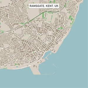
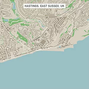
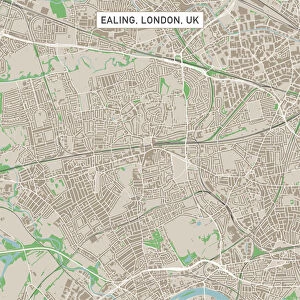
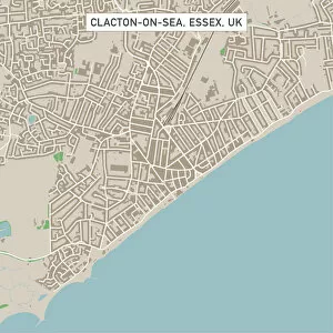
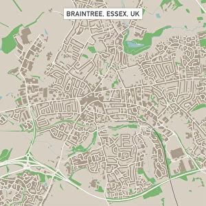
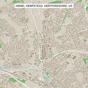
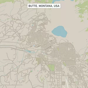
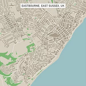
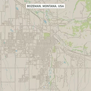
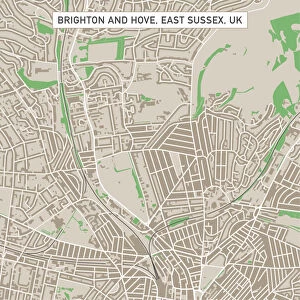
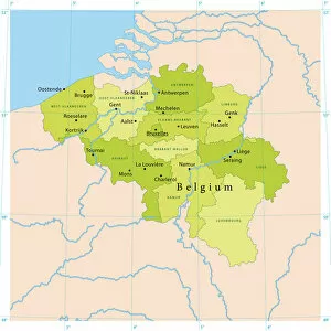
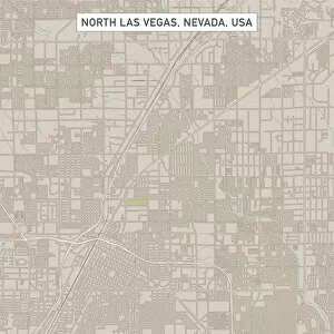
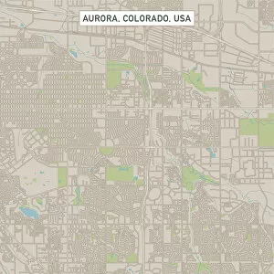
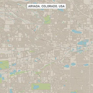
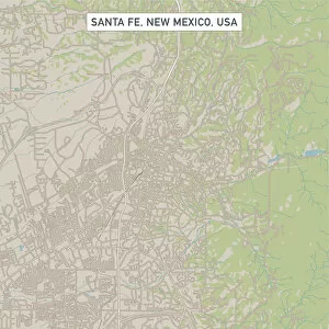
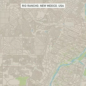
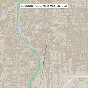
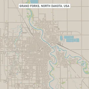
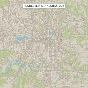
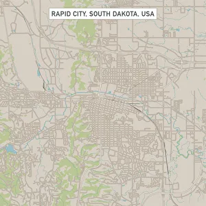
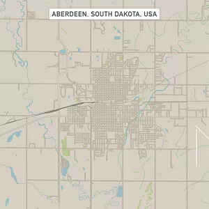
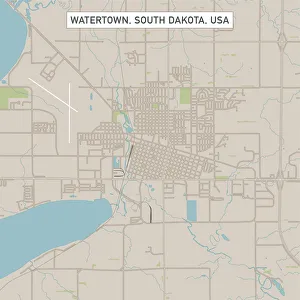
"Exploring the Boundless World of Digitally Generated Images: From Snellen Charts to Capybaras and Everything In Between" A black and white illustration of a Snellen chart, showcasing the precision of digitally generated images. Colour coded jackets for greyhound race dogs, brought to life through digital artistry that adds vibrancy to the racing scene. An adrenaline-pumping waterskiing slalom course captured in a digitally enhanced image, highlighting the thrill of extreme sports. A map of the world with meticulously drawn lines marking boundaries of tectonic plates, illustrating how technology can visually depict complex geological phenomena. A snooker player gracefully maneuvering around a table in an intricately detailed digital illustration that captures every moment of this beloved sport. Costa Rica's beauty comes alive in a vector map created using advanced digital techniques, allowing us to explore its diverse landscapes from coastlines to rainforests. Water polo players immersed in action within a swimming pool while referees closely monitor each move - all brought together through stunning digital imagery. Navigating Ipswich Suffolk UK becomes effortless with a city street map crafted using cutting-edge technology, making it easier for residents and visitors alike to find their way around town. The netball goal ring and net stand out vividly against vibrant backgrounds thanks to digitally rendered images that enhance this popular team sport's visual appeal. Witness the elegance and intensity as a Kendo martial arts fighter holds his sword before him in an awe-inspiring digital illustration capturing both strength and gracefulness simultaneously. Delve into South America's wildlife with a captivating digital portrayal of the Capybara - showcasing its unique characteristics as one of nature's fascinating creatures. Four scullers rowing together seamlessly on a quad boat come alive through digitally enhanced imagery, emphasizing teamwork and synchronization on waterways worldwide.