Fraud Blocker Skip to main content

Earth Observation Collection (page 2)

"Earth Observation: Glimpses of Our Pale Blue Dot and Beyond" In the vast expanse of space

Background imageEarth Observation Collection: Brisbane, Australia, satellite image

Brisbane, Australia, satellite image. North is at top, water is blue, shallow coastal areas are light blue, urban areas are grey and vegetation is green

Background imageEarth Observation Collection: Africa, satellite image

Africa, satellite image
Africa. Satellite image of the Earth centred on Africa. Clouds are white, oceans are blue and land is green and brown. Also seen are Europe (top) Asia (upper right), the Indian Ocean (right)

Background imageEarth Observation Collection: Karbala, Iraq

Karbala, Iraq. Satellite image of Karbala, the capital city of the Al Karbala province, Iraq. Shi a Muslims consider it to be one of the holiest places in the world

Background imageEarth Observation Collection: Richat Structure, satellite image

Richat Structure, satellite image. North is at top. Desert sands are pale yellow/white (top left and lower right), while less sandy, rocky areas are green, and volcanic rocks are blue

Background imageEarth Observation Collection: Southeast Asia at night, satellite image

Southeast Asia at night, satellite image
Southeast Asia at night. Satellite image of the Earth seen at 18:00 (6pm) GMT (UCT), centred on China. City lights (yellow) show areas of dense population, particularly in India (left)

Background imageEarth Observation Collection: Italy at night, ISS image

Italy at night, ISS image
Italy at night. International Space Station (ISS) image of Italy (centre) and the Adriatic coast (right) at night. The island of Sicily is at centre left

Background imageEarth Observation Collection: Africa, night-day satellite image

Africa, night-day satellite image. This composite image of the Earth is set against a background of stars, and is centred on the continent of Africa. North is at top

Background imageEarth Observation Collection: Whole Earth at night, satellite image

Whole Earth at night, satellite image. This map is centred on the Greenwich meridian, at zero degrees latitude. City lights (yellow) show areas of dense population

Background imageEarth Observation Collection: North America at night, satellite image

North America at night, satellite image
North America at night. Black marble satellite image of North America at night. More densely populated areas are brighter

Background imageEarth Observation Collection: World map, February 2004

World map, February 2004
World Map. Blue Marble: Next Generation cloud-free true-colour composite image of the Earth in February 2004. It is winter in the Northern Hemisphere and large areas of land are covered in snow

Background imageEarth Observation Collection: Europe at night, 1993-2003 changes

Europe at night, 1993-2003 changes
Europe at night, showing the change in illumination from 1993-2003. This data is based on satellite observations. Lights are colour-coded. Red lights appeared during that period

Background imageEarth Observation Collection: Middle East, satellite image

Middle East, satellite image
Middle East. North is at top. Satellite image of the Middle East, showing the borders (white lines) of the countries. The Middle East is a Eurocentric term used to describe a region that roughly

Background imageEarth Observation Collection: Bluewater shopping centre, aerial image

Bluewater shopping centre, aerial image
Bluewater shopping centre, UK, aerial image. This is an out of town shopping centre in Greenhithe in Kent. It opened in March 1999 and has since attracted around 27 million visitors per year

Background imageEarth Observation Collection: Oxford, UK, aerial image

Oxford, UK, aerial image

Background imageEarth Observation Collection: Eastern Himalayas, satellite image

Eastern Himalayas, satellite image. North is at top. Snow is white, vegetation is red, barren areas are light blue and water is dark blue

Background imageEarth Observation Collection: Desert alluvial fan, satellite image

Desert alluvial fan, satellite image. North is at top. Desert areas can sometimes go for years without rain, and then intense storms will cause flooding that fills old dry river beds

Background imageEarth Observation Collection: Europe, satellite image

Europe, satellite image
Europe. Satellite image centred on Europe. North converges towards top. Water is blue, vegetation is green, arid areas are brown, and snow and ice are white

Background imageEarth Observation Collection: Denmark - Sweden border, satellite image

Denmark - Sweden border, satellite image
Denmark. Satellite image of the European country of Denmark (left) and the surrounding area. North is at top. Water is blue, vegetation is green

Background imageEarth Observation Collection: International Space Station, 2010

International Space Station, 2010
International Space Station (ISS), February 2010, taken from the Space Shuttle Endeavour prior to docking at the beginning of its mission to the ISS

Background imageEarth Observation Collection: Great Sandy Desert, satellite image

Great Sandy Desert, satellite image. North is at upper left. Vegetation is green and purple, while more barren, rocky areas are various shades of white and brown

Background imageEarth Observation Collection: Great Salt Desert, satellite image

Great Salt Desert, satellite image. North is at top. Desert soil and mud is light brown, barren rocky areas are pink, and salt pans are blue

Background imageEarth Observation Collection: North America at night

North America at night, satellite image. North is at top. Yellow lights mark the major cities. The western coast of the USA is the most brightly lit area, with the urban area of Los Angeles

Background imageEarth Observation Collection: Australia at night, satellite image

Australia at night, satellite image. City lights (yellow) show areas of more dense population, particularly in Southeast Asia (top left) and on Australias east coast

Background imageEarth Observation Collection: New York City, satellite image

New York City, satellite image
New York City, USA, satellite image. North is attop. Urban areas are white, vegetation is greenand water is blue. The island of Manhattan is atupper centre on the east coast of the HudsonRiver

Background imageEarth Observation Collection: The Great Lakes, ISS image C016 / 3870

The Great Lakes, ISS image C016 / 3870
The Great Lakes. View from the International Space Station (ISS) of the Great Lakes of the USA and Canada. North is towards upper right. Here, the ISS is over a point to the southeast of Nova Scotia

Background imageEarth Observation Collection: Sandstorm, satellite image

Sandstorm, satellite image
Sandstorm, Aqua satellite image. Cloud of sand stretching into the Mediterranean Sea (blue). The sand is being blown from the Great Sand Sea

Background imageEarth Observation Collection: Mannheim, satellite image

Mannheim, satellite image
Mannheim, Germany, satellite image. Mannheim is situated in the state of Baden-Wuttemburg. The city has a population of around 320

Background imageEarth Observation Collection: Hemel Hempstead, UK, aerial image

Hemel Hempstead, UK, aerial image
Hemel Hempstead, UK, aerial photograph. Hemel Hempstead is a town in Hertfordshire, England. It was developed after World War II as a new town, but has existed since the 8th century

Background imageEarth Observation Collection: Sun from Earth orbit

Sun from Earth orbit, computer artwork

Background imageEarth Observation Collection: Asia

Asia. Computer artwork, based on a satellite image, of Asia. North is at top. Water is blue, vegetation is green and desert is yellow

Background imageEarth Observation Collection: Asia, satellite image

Asia, satellite image. The land is mostly covered by vegetation and seen as the green areas. Deserts are shown in yellow, and mountain ranges are grey

Background imageEarth Observation Collection: Orbiting Carbon Observatory, artwork

Orbiting Carbon Observatory, artwork
Orbiting Carbon Observatory (OCO) in Earth orbit, artwork. A NASA mission, the OCO was designed to make global measurements of levels of the greenhouse gas carbon dioxide

Background imageEarth Observation Collection: Asia at night

Asia at night, satellite image. North is towards top right. Yellow lights mark the major cities. Japan (far right), the most brightly lit country, has densely populated urban areas

Background imageEarth Observation Collection: Coriolis effect, artwork C017 / 7212

Coriolis effect, artwork C017 / 7212
Coriolis effect. Computer artwork of a globe, showing how the Coriolis effect affects the motion (red arrows) of free-moving objects in the northern and southern hemispheres of the Earth

Background imageEarth Observation Collection: Japan at night, satellite image

Japan at night, satellite image
Japan at night. Black marble satellite image of Japan at night. More densely populated areas are brighter. Lights from ships at sea are also shown

Background imageEarth Observation Collection: Australia at night, satellite image

Australia at night, satellite image
Australia at night. Black marble satellite image of Australia at night. Wildfires burning in the bush are seen as well as city lights

Background imageEarth Observation Collection: Africa at night, satellite image

Africa at night, satellite image
Africa at night. Black marble satellite image of Africa at night. More densely populated areas are brighter. The Nile is illuminated by the many boats along its length

Background imageEarth Observation Collection: Asia at night, satellite image

Asia at night, satellite image
Asia at night. Black marble satellite image of Asia at night. More densely populated areas are brighter. The nocturnal glow produced by the Earths atmosphere is shown as well as man-made light

Background imageEarth Observation Collection: Sputnik 1 satellite, composite image

Sputnik 1 satellite, composite image
Sputnik 1. Composite image of Sputnik 1, the worlds first artificial satellite against a backdrop of the Moon above Earths horizon. The Sun and the Earth are reflected on the satellites surface

Background imageEarth Observation Collection: Middle East

Middle East, satellite image. North is at top. Vegetation is green, water is dark blue and bare ground, mostly desert, is yellow-brown

Background imageEarth Observation Collection: Earth at time of Pangea

Earth at time of Pangea
Future Earth. Computer artwork of the position of Earths continents around 250 million years in the future. A new supercontinent, Pangea Ultima, has formed

Background imageEarth Observation Collection: Hawai i, satellite image

Hawai i, satellite image. Satellite image of the island of Hawai i, also known as Big Island. Vegetation is green, water is blue, and cloud is white

Background imageEarth Observation Collection: Europe, night-day satellite image

Europe, night-day satellite image. This composite image of the Earth is set against a background of stars, and is centred on Europe. North is at top

Background imageEarth Observation Collection: The Arctic, satellite image

The Arctic, satellite image
The Arctic. Satellite image of the Earth centred on the Arctic. The North Pole is at centre. Clouds and Arctic sea ice are white, oceans are blue and land is green and brown

Background imageEarth Observation Collection: The Kamchatka Peninsula of far eastern Russian

The Kamchatka Peninsula of far eastern Russian
May 23, 2013 - The Kamchatka Peninsula of far eastern Russian was surrounded by life in late May 2013, at least the oceanic sort

Background imageEarth Observation Collection: Aerial view of Pingualuit Crater, Quebec, Canada

Aerial view of Pingualuit Crater, Quebec, Canada
October 12, 2007 - Aerial view of Pingualuit Crater, Quebec, Canada. The crater was formed millions of years ago by meteorites striking the surface, and today they hold deep lakes

Background imageEarth Observation Collection: New York City from space

New York City from space, ISS image. New York City photographed from the International Space Station on the 14th March 2012

Background imageEarth Observation Collection: Earth and moon, ISS image

Earth and moon, ISS image
Earth and moon taken by astronauts on the International Space Shuttle (ISS). Photographed 21st October 2011


All Professionally Made to Order for Quick Shipping

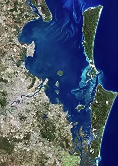
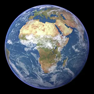
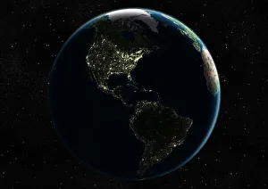
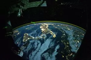
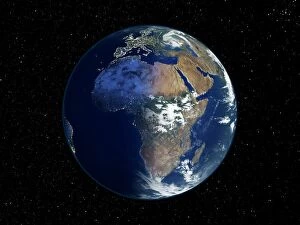
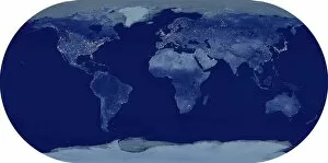
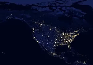
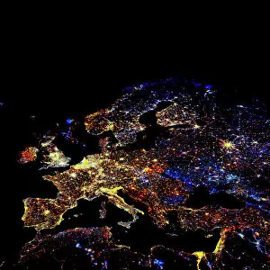
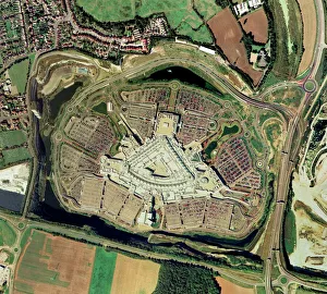
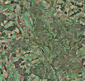
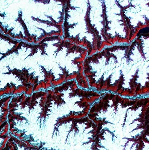
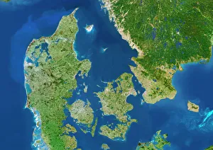
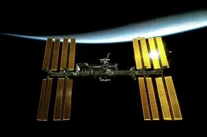
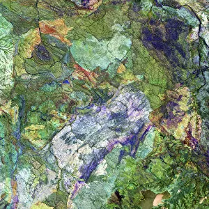
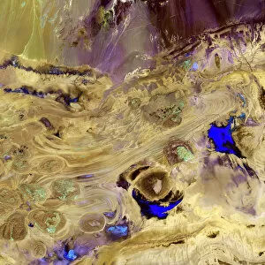
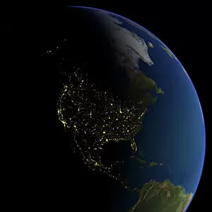
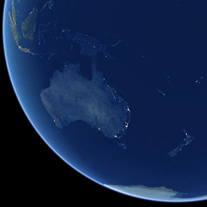
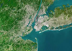
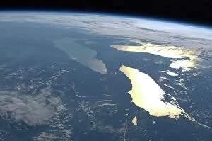
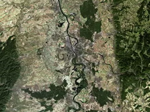
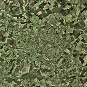
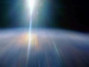
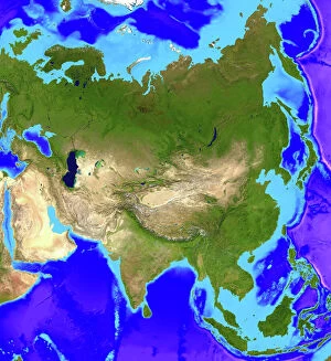
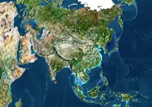
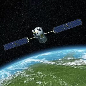
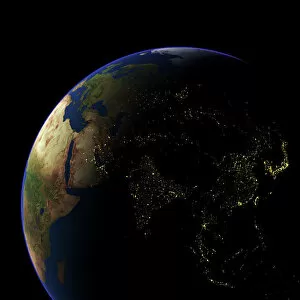
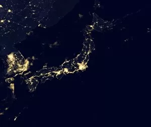
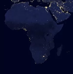
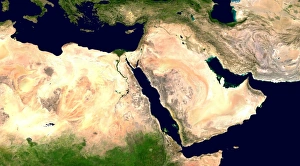
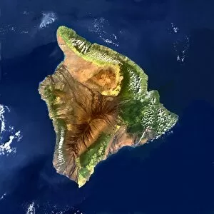
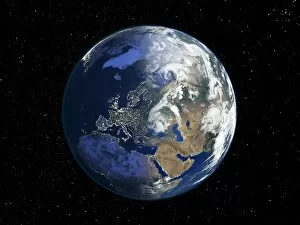
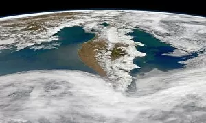
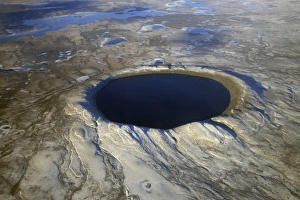
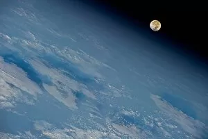
"Earth Observation: Glimpses of Our Pale Blue Dot and Beyond" In the vast expanse of space, Voyager 1 captured an awe-inspiring image that forever changed our perspective. The iconic "Pale Blue Dot" photograph revealed Earth as a tiny speck in the cosmic ocean, reminding us of our interconnectedness on this magnificent planet. Zooming in closer, we witness the intricate details of human achievements. The Wimbledon tennis complex stands out amidst the bustling cityscape of London, UK. From high above, a satellite image showcases the British Isles with its lush green landscapes and rugged coastlines – a testament to nature's beauty. As night falls, lights illuminate cities across Europe like constellations on Earth's canvas. A mesmerizing satellite image captures the brilliance of UK at night from space – a tapestry woven by millions living their lives under starry skies. Expanding further into darkness reveals Europe at night; clusters of light representing vibrant metropolises and quiet towns alike. And then there it is - an astonishing view showcasing our entire planet bathed in nocturnal glow - Whole Earth at night seen from space. Venturing beyond terrestrial boundaries, Tenerife emerges through a satellite lens – its volcanic terrain contrasting against azure waters surrounding this Spanish island paradise. The International Space Station floats gracefully in orbit around Earth during 2008 – humanity's outpost where astronauts conduct research while gazing back upon their home planet with wonderment. From afar, another satellite image depicts Earth from space - swirling clouds dance over continents and oceans; an ever-changing masterpiece painted by atmospheric currents and weather patterns. Closer to home once more, Scotland's stunning landscape unfolds beneath us through yet another captivating satellite image. Majestic mountains blend seamlessly with lochs and glens creating breathtaking scenery that captivates all who behold it.