Fraud Blocker Skip to main content

Fairbank Collection

"Unveiling the Historical Tapestry of Fairbank

Background imageFairbank Collection: A correct plan of the town of Sheffield by William Fairbank, 1771

A correct plan of the town of Sheffield by William Fairbank, 1771
Scale 440 yards : 3.3 inches. Shows the Bull Stake, slaughterhouses, Town Mill, Irish Cross. Original at Local Studies y09647

Background imageFairbank Collection: A Plan of the town of Sheffield in the county of York drawn by W. Fairbank 1797

A Plan of the town of Sheffield in the county of York drawn by W. Fairbank 1797. Engraved by Thomas Harris
Original at Sheffield Local Studies Library:s 45 S

Background imageFairbank Collection: Norton from the survey of W and J Fairbank, 1804

Norton from the survey of W and J Fairbank, 1804
Original at Sheffield Archives ref. NSC/127

Background imageFairbank Collection: Plan of Rockingham Street, Division Street, Rockingham Lane and Carver Street, Sheffield, 1829

Plan of Rockingham Street, Division Street, Rockingham Lane and Carver Street, Sheffield, 1829
Full title: Plan of certain building land the property of Messrs Brittain, Wilkinson and Brownell. Steel furnaces, cutlers shops and warehouse marked. Surveyed and drawn by J. Fairbank and Son

Background imageFairbank Collection: Trade card for the Fairbank Canning Company, Chicago, Illinois, c1890. Lion Brand corned beef

Trade card for the Fairbank Canning Company, Chicago, Illinois, c1890. Lion Brand corned beef
531684 Trade card for the Fairbank Canning Company, Chicago, Illinois, c1890. Lion Brand corned beef. In background, cattle are entering abattoir and canning factory

Background imageFairbank Collection: Plan of part of the townships of Sheffield and Nether Hallam, Sheffield, c. 1826

Plan of part of the townships of Sheffield and Nether Hallam, Sheffield, c. 1826
Full title: Plan of part of the townships of Sheffield and Nether Hallam which is in dispute. Includes John Addys house, Lidgate Field, Shales Moor Close, White House Lane or Walkley Road

Background imageFairbank Collection: Plan of Holt House estate, Abbeydale, Sheffield, 1823

Plan of Holt House estate, Abbeydale, Sheffield, 1823
By W. and J. Fairbank, 1823. Landowners shown: Edward Loukas, John Crowshaw, Peter Wigfull, Earl Fitzwilliam and Richard Swallow

Background imageFairbank Collection: Owlerton. Lady Burgoynes land - White House, High House, Hill Foot, Limerick Wheel, Sheffield

Owlerton. Lady Burgoynes land - White House, High House, Hill Foot, Limerick Wheel, Sheffield, [1825]
Includes: Hill Bridge, River Loxley, River Dun [Don], Limerick [Limbrick] Wheels, Barracks, Hill Foot, Cuthbert Bank Wood, Rawson Spring wood

Background imageFairbank Collection: Plan of Owlerton Hall estate, Sheffield [1825]

Plan of Owlerton Hall estate, Sheffield [1825]
The property of Lady Burgoyne. From an original at Sheffield Libraries: arc03995

Background imageFairbank Collection: Plan of Ranmoor and Nether Green, Sheffield, 1830

Plan of Ranmoor and Nether Green, Sheffield, 1830
Full title: Plan of estates at Rand Moor [Ranmoor] and Nether Green in the township of Upper Hallam the property of John Eyre

Background imageFairbank Collection: Endcliffe Crescent, Sheffield. c. 1830

Endcliffe Crescent, Sheffield. c. 1830
Full title: The Endcliffe Building Companys land as finally divided Original at Sheffield City Libraries: arc03957

Background imageFairbank Collection: Plan of Nether Heeley, Sheffield, 1783

Plan of Nether Heeley, Sheffield, 1783
Full title: Plan of Nether Heeley particularly describing all the Cottages there which are held of the Earl of Surrey, From an original at Sheffield Libraries: arc02729

Background imageFairbank Collection: Map of land at Heeley, Sheffield, 1758

Map of land at Heeley, Sheffield, 1758
Full title: Map of several intermixed parcels of land at Heeley, the property of the Duke of Norfolk and S. Shore, esquire

Background imageFairbank Collection: Map of Owlerbottoms in Stephen Hawksworths Farm, Nether Green, Sheffield, 1746

Map of Owlerbottoms in Stephen Hawksworths Farm, Nether Green, Sheffield, 1746
Scale 2 chains : 1 inch [40 inches : 1 mile] Surveyor: William Fairbank I. Woodland alongside the Porter Brook, west of Smith Wood; acreage of the whole; boundary trees and border coloured

Background imageFairbank Collection: Plan of the Snuff Mill, Cutlers Wheel, adjoining the Dam etc at Sharrow Moor, Sheffield, 1764

Plan of the Snuff Mill, Cutlers Wheel, adjoining the Dam etc at Sharrow Moor, Sheffield, 1764
Scale 45 yards : 1 inch [approx. 40 inches : 1 mile]. Surveyor: William Fairbank II. Weir, dam and wheel shown; a note explains the extension of the new weir into Hare Park

Background imageFairbank Collection: Canada, Ontario, Fairbank Provincial Park. Sugar maple tree leaves cover road in autumn

Canada, Ontario, Fairbank Provincial Park. Sugar maple tree leaves cover road in autumn. Date: 08-10-2014

Background imageFairbank Collection: Lancaster LA6 2 Map

Lancaster LA6 2 Map
Postcode Sector Map of Lancaster LA6 2

Background imageFairbank Collection: A house in Coleman Street, City of London, 1865

A house in Coleman Street, City of London, 1865

Background imageFairbank Collection: Interior of Pickfair

Interior of Pickfair
The upstairs hall made into a sitting-room at Pickfair, the Beverly Hills home of Mary Pickford and Douglas Fairbanks Snr. Date: 1928

Background imageFairbank Collection: Trade card for the Fairbank Canning Company, Chicago, Illinois, c1890. Lion Brand corned beef

Trade card for the Fairbank Canning Company, Chicago, Illinois, c1890. Lion Brand corned beef. In background, cattle are entering abattoir and canning factory. Chromolithograph

Background imageFairbank Collection: Fairbanks cherubs--Presented with the compliments of N. K. F

Fairbanks cherubs--Presented with the compliments of N. K. F
Fairbanks cherubs--Presented with the compliments of N.K. Fairbank & Co. lard refiners, Chicago & St. Louis. Two angelic piglets. Date ca. 1890


All Professionally Made to Order for Quick Shipping

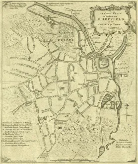
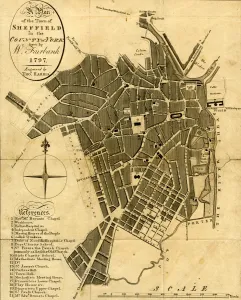
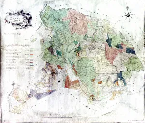
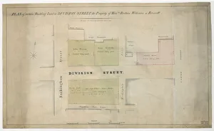
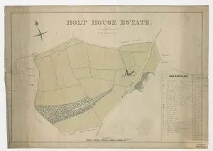
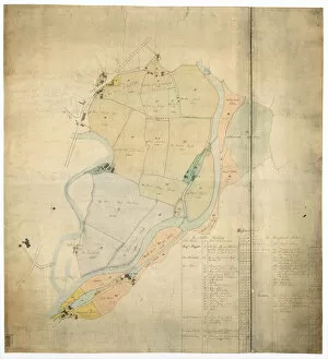
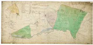
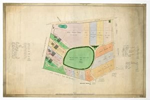
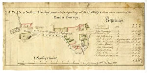
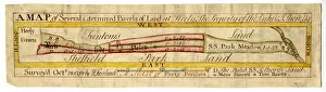
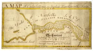
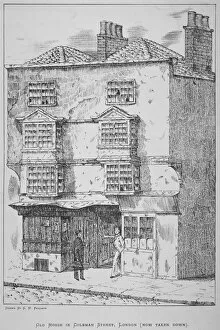
"Unveiling the Historical Tapestry of Fairbank: A Journey through Sheffield's Past" Step into the rich history of Sheffield with a glimpse into the meticulous plans and maps crafted by William Fairbank. In 1771, his accurate depiction of the town in "A Correct Plan of the Town of Sheffield" offered a window into its layout and structure. The intricate details were further refined in 1797 when W. Fairbank drew "A Plan of the Town of Sheffield, " later engraved by Thomas Harris. As time progressed, more areas were explored and documented. The survey conducted by W and J Fairbank in 1804 revealed Norton's hidden gems, showcasing its unique charm within Yorkshire County. Moving forward to c. 1826, a captivating plan emerged, revealing part of both Sheffield and Nether Hallam townships. Delving deeper into specific locations within Sheffield, we discover Owlerton's intriguing landmarks such as Lady Burgoynes land - White House, High House, Hill Foot, Limerick Wheel - all captured on paper in 1825. Meanwhile, Owlerton Hall estate was meticulously mapped out during that same year. The evolving landscape continued to be recorded for posterity; Ranmoor and Nether Green found their place on a detailed plan from 1830 while Nether Heeley was skillfully depicted back in 1783. Venturing beyond city limits reveals fascinating insights too – Stephen Hawksworths Farm at Nether Green is immortalized on a map dating back to 1746 while Heeley's land unfolds before our eyes with an exquisite map from 1758. Not forgetting Sharrow Moor’s industrial heritage. In 1764 came "Plan of the Snuff Mill, " offering an intimate look at Cutlers Wheel adjoining the Dam – remnants that tell tales from yesteryears. While exploring these historical treasures may transport us back centuries ago, it is essential not to overlook the present.