Fraud Blocker Skip to main content

Geographical Border Collection

"Exploring the Geographical Borders

Background imageGeographical Border Collection: China map

China map
illustration of a South Eastern Asia map

Background imageGeographical Border Collection: Ancient and Modern Jerusalem Map Engraving

Ancient and Modern Jerusalem Map Engraving
Engraved illustration of Ancient and Modern Jerusalem Map Engraving from The Popular Pictorial Bible, Containing the Old and New Testaments, Published in 1862. Copyright has expired on this artwork

Background imageGeographical Border Collection: Travels of The Apostle Paul Map Engraving

Travels of The Apostle Paul Map Engraving
Engraved illustration of the Travels of The Apostle Paul Map Engraving from The Popular Pictorial Bible, Containing the Old and New Testaments, Published in 1862

Background imageGeographical Border Collection: MA Middlesex Westford Vector Road Map

MA Middlesex Westford Vector Road Map. All source data is in the public domain. U.S. Census Bureau Census Tiger. Used Layers: areawater, linearwater, roads, rails, cousub, pointlm, uac10

Background imageGeographical Border Collection: Singapore

Singapore
Antique illustration of a Republic of Singapore

Background imageGeographical Border Collection: First light on Bonneville Salt Flats near the Utah-Nevada border

First light on Bonneville Salt Flats near the Utah-Nevada border. The morning light highlights the delicate colors of the salt crystal patterns that form on the crust of the surface

Background imageGeographical Border Collection: Romania

Romania
Antique map of Romania

Background imageGeographical Border Collection: Turkey, Satellite Image

Turkey, Satellite Image
Satellite view of Turkey. This image was compiled from data acquired by LANDSAT satellite

Background imageGeographical Border Collection: Departement of Ille-et-Vilaine, France, Relief Map

Departement of Ille-et-Vilaine, France, Relief Map
Relief map of the departement of Ille-et-Vilaine, France. It is bordered by the English Channel to the north. This image was compiled from data acquired by LANDSAT 5 & 7 satellites combined with

Background imageGeographical Border Collection: MA Essex Swampscott Vector Road Map

MA Essex Swampscott Vector Road Map. All source data is in the public domain. U.S. Census Bureau Census Tiger. Used Layers: areawater, linearwater, roads, rails, cousub, pointlm, uac10

Background imageGeographical Border Collection: MA Barnstable Town Vector Road Map

MA Barnstable Town Vector Road Map. All source data is in the public domain. U.S. Census Bureau Census Tiger. Used Layers: areawater, linearwater, roads, rails, cousub, pointlm, uac10

Background imageGeographical Border Collection: Antique India Map

Antique India Map
India Map, - Antique style. Includes mountains and water bodies. High detail - vector illustration

Background imageGeographical Border Collection: London and Environs Historical Map, Engraving, 1892

London and Environs Historical Map, Engraving, 1892
Very rare, beautifully detailed engraving of London and Environs Historical Map, Engraving, Published in 1892. Original edition from my own archives. Copyright has expired on this artwork

Background imageGeographical Border Collection: Niger, Satellite Image

Niger, Satellite Image
Satellite view of Niger. This image was compiled from data acquired by LANDSAT satellite

Background imageGeographical Border Collection: Canton of Appenzell Ausserrhoden, Switzerland, Relief Map

Canton of Appenzell Ausserrhoden, Switzerland, Relief Map
Relief map of the canton of Appenzell Ausserrhoden, Switzerland. This image was compiled from data acquired by LANDSAT 5 & 7 satellites combined with elevation data

Background imageGeographical Border Collection: Antique Ukraine Map

Antique Ukraine Map
Ukraine Map, - Antique style. Includes mountains and water bodies. High detail - vector illustration

Background imageGeographical Border Collection: Antique Finland Map

Antique Finland Map
Finland Map, - Antique style. Includes mountains and water bodies. High detail - vector illustration

Background imageGeographical Border Collection: Map of Italy, c.1900 (engraving)

Map of Italy, c.1900 (engraving)
532986 Map of Italy, c.1900 (engraving); (add.info.: Map of northern Italy, circa 1902, from the 10th edition of Encyclopaedia Britannica.); Encyclopaedia Britannica/UIG.

Background imageGeographical Border Collection: Map of Switzerland and Liechtenstein, c.1900 (engraving)

Map of Switzerland and Liechtenstein, c.1900 (engraving)
532974 Map of Switzerland and Liechtenstein, c.1900 (engraving); (add.info.: Map showing historical boundaries of Switzerland and Liechtenstein, circa 1902)

Background imageGeographical Border Collection: Map of the northern part of the German Empire, c.1900 (engraving)

Map of the northern part of the German Empire, c.1900 (engraving)
532959 Map of the northern part of the German Empire, c.1900 (engraving); (add.info.: Map of the northern part of the German empire, circa 1902)

Background imageGeographical Border Collection: Map of the northern part of Missouri, c.1900 (engraving)

Map of the northern part of Missouri, c.1900 (engraving)
533200 Map of the northern part of Missouri, c.1900 (engraving); (add.info.: Map of the northern part of Missouri with inset maps of Kansas City and St)

Background imageGeographical Border Collection: Map of Nebraska with inset of Omaha, c.1900 (engraving)

Map of Nebraska with inset of Omaha, c.1900 (engraving)
533197 Map of Nebraska with inset of Omaha, c.1900 (engraving); (add.info.: Map of Nebraska, United States, with an inset map of Omaha, circa 1902)

Background imageGeographical Border Collection: Map of Kentucky, c.1900 (engraving)

Map of Kentucky, c.1900 (engraving)
533143 Map of Kentucky, c.1900 (engraving); (add.info.: Map of Kentucky, United States, circa 1902, from the 10th edition of Encyclopaedia Britannica.); Encyclopaedia Britannica/UIG.

Background imageGeographical Border Collection: Map of Pennsylvania with inset map of Philadelphia, c.1900 (engraving)

Map of Pennsylvania with inset map of Philadelphia, c.1900 (engraving)
533115 Map of Pennsylvania with inset map of Philadelphia, c.1900 (engraving); (add.info.: Map of eastern Pennsylvania with inset map of Philadelphia, circa 1902)

Background imageGeographical Border Collection: Map of New York State, c.1900 (engraving)

Map of New York State, c.1900 (engraving)
533109 Map of New York State, c.1900 (engraving); (add.info.: Map of western New York State, with inset map of Buffalo, Niagara Frontier, and Rochester, circa 1902)

Background imageGeographical Border Collection: Map of New York State, c.1900 (engraving)

Map of New York State, c.1900 (engraving)
533104 Map of New York State, c.1900 (engraving); (add.info.: Map of southern New York State, United States, insets map of New York City, the Hudson River, and the Catskill Mountains, circa 1902)

Background imageGeographical Border Collection: Map of North America and Central America, c.1900 (engraving)

Map of North America and Central America, c.1900 (engraving)
533069 Map of North America and Central America, c.1900 (engraving); (add.info.: Map of North America and Central America, circa 1902)

Background imageGeographical Border Collection: Map of Southern Africa, c.1900 (engraving)

Map of Southern Africa, c.1900 (engraving)
533065 Map of Southern Africa, c.1900 (engraving); (add.info.: Map of colonial southern Africa, with insets of Cape Town, Johannesburg, and Ladysmith, circa 1902)

Background imageGeographical Border Collection: Map of Chattanooga, c.1900 (engraving)

Map of Chattanooga, c.1900 (engraving)
532737 Map of Chattanooga, c.1900 (engraving); (add.info.: Map of Chattanooga, Tennessee, circa 1900, from the 10th edition of Encyclopaedia Britannica.); Encyclopaedia Britannica/UIG.

Background imageGeographical Border Collection: Map of Buenos Aires and Montevideo, c.1900 (engraving)

Map of Buenos Aires and Montevideo, c.1900 (engraving)
533500 Map of Buenos Aires and Montevideo, c.1900 (engraving); (add.info.: Inset map of Buenos Aires (Argentina) and Montevideo (Uruguay), circa 1902

Background imageGeographical Border Collection: Map of East India Islands with New Guinea, c.1900 (engraving)

Map of East India Islands with New Guinea, c.1900 (engraving)
533036 Map of East India Islands with New Guinea, c.1900 (engraving); (add.info.: Map of East India Islands, with an inset of New Guinea, circa 1902)

Background imageGeographical Border Collection: Map of China, c.1900 (engraving)

Map of China, c.1900 (engraving)
533028 Map of China, c.1900 (engraving); (add.info.: Map of China, circa 1902, from the 10th edition of Encyclopaedia Britannica.); Encyclopaedia Britannica/UIG.

Background imageGeographical Border Collection: Map of Arabia with part of Turkey and Oman, c.1900 (engraving)

Map of Arabia with part of Turkey and Oman, c.1900 (engraving)
533009 Map of Arabia with part of Turkey and Oman, c.1900 (engraving); (add.info.: Map of Arabia, Turkey, Oman, Aden, with insets map of Jerusalem and Palestine, circa 1902)

Background imageGeographical Border Collection: Map of Turkey, c.1900 (engraving)

Map of Turkey, c.1900 (engraving)
533006 Map of Turkey, c.1900 (engraving); (add.info.: Map showing the historical boundaries of Turkey in Asia, circa 1902)

Background imageGeographical Border Collection: Map of Russia with inset of St. Petersburg, c.1900 (engraving)

Map of Russia with inset of St. Petersburg, c.1900 (engraving)
532995 Map of Russia with inset of St. Petersburg, c.1900 (engraving); (add.info.: Map of Russia, with an inset of St. Petersburg, circa 1902)

Background imageGeographical Border Collection: Map of the northwestern part of South America, c.1900 (engraving)

Map of the northwestern part of South America, c.1900 (engraving)
533259 Map of the northwestern part of South America, c.1900 (engraving); (add.info.: Map of northwest South America: Colombia, Venezuela, British Guiana, Ecuador, Peru, and Bolivia, circa 1902)

Background imageGeographical Border Collection: Map of Colorado, c.1900 (engraving)

Map of Colorado, c.1900 (engraving)
533216 Map of Colorado, c.1900 (engraving); (add.info.: Map of Colorado, United States, circa 1902, from the 10th edition of Encyclopaedia Britannica.); Encyclopaedia Britannica/UIG.

Background imageGeographical Border Collection: Map of Montana, c.1900 (engraving)

Map of Montana, c.1900 (engraving)
533209 Map of Montana, c.1900 (engraving); (add.info.: Map of Montana, United States, circa 1902, from the 10th edition of Encyclopaedia Britannica.); Encyclopaedia Britannica/UIG.

Background imageGeographical Border Collection: Map of Oklahoma and the Indian Territory, c.1900 (engraving)

Map of Oklahoma and the Indian Territory, c.1900 (engraving)
533207 Map of Oklahoma and the Indian Territory, c.1900 (engraving); (add.info.: Map of Oklahoma and the Indian Territory, United States, circa 1902)

Background imageGeographical Border Collection: Map of Iowa, c.1900 (engraving)

Map of Iowa, c.1900 (engraving)
533195 Map of Iowa, c.1900 (engraving); (add.info.: Map of Iowa, United States, circa 1902, from the 10th edition of Encyclopaedia Britannica.); Encyclopaedia Britannica/UIG.

Background imageGeographical Border Collection: Map of northern Ohio, c.1900 (engraving)

Map of northern Ohio, c.1900 (engraving)
533164 Map of northern Ohio, c.1900 (engraving); (add.info.: Map of the northern part of Ohio, United States, circa 1902, from the 10th edition of Encyclopaedia Britannica)

Background imageGeographical Border Collection: Map of Alabama, c.1900 (engraving)

Map of Alabama, c.1900 (engraving)
533151 Map of Alabama, c.1900 (engraving); (add.info.: Map of Alabama, United States, circa 1902, from the 10th edition of Encyclopaedia Britannica.); Encyclopaedia Britannica/UIG.

Background imageGeographical Border Collection: Map of Quebec, Canada, c.1900 (engraving)

Map of Quebec, Canada, c.1900 (engraving)
533080 Map of Quebec, Canada, c.1900 (engraving); (add.info.: Map of Quebec, Canada, with insets of Quebec City and Montreal, circa 1902)

Background imageGeographical Border Collection: Map of Japan and Korea, c.1900 (engraving)

Map of Japan and Korea, c.1900 (engraving)
533031 Map of Japan and Korea, c.1900 (engraving); (add.info.: Map of Japan and Korea, with insets of Kurile Islands, Liu-Kiu Islands and Formosa, circa 1902)

Background imageGeographical Border Collection: Map of southern India with Bombay, c.1900 (engraving)

Map of southern India with Bombay, c.1900 (engraving)
533019 Map of southern India with Bombay, c.1900 (engraving); (add.info.: Map showing historical boundaries of Southern India with inset map of Bombay (now Mumbai) and the Malay Peninsula

Background imageGeographical Border Collection: Map of Italy, c.1900 (engraving)

Map of Italy, c.1900 (engraving)
532983 Map of Italy, c.1900 (engraving); (add.info.: Map of Italy, with insets of Rome and Venice, circa 1902, from the 10th edition of Encyclopaedia Britannica.); Encyclopaedia Britannica/UIG.

Background imageGeographical Border Collection: Map of the Empire of Austria-Hungary, c.1900 (engraving)

Map of the Empire of Austria-Hungary, c.1900 (engraving)
532977 Map of the Empire of Austria-Hungary, c.1900 (engraving); (add.info.: Map of Empire of Austria-Hungary and inset of Budapest and Vicinity, circa 1902)

Background imageGeographical Border Collection: Map of the southwestern part of the German Empire, c.1900 (engraving)

Map of the southwestern part of the German Empire, c.1900 (engraving)
532961 Map of the southwestern part of the German Empire, c.1900 (engraving); (add.info.: Map of the southwestern German Empire, circa 1902)


All Professionally Made to Order for Quick Shipping

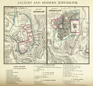
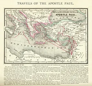
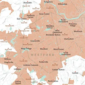
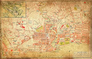
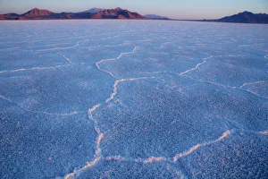
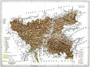
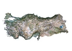
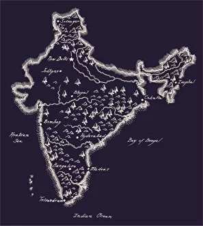
"Exploring the Geographical Borders: From Ancient Jerusalem to Modern Singapore" Embark on a captivating journey through geographical borders as we delve into diverse landscapes and historical realms. 🌍✈️ Starting with China's intricate map, witness the vastness of this ancient civilization that has stood the test of time. πŸ‡¨πŸ‡³ Next, trace the travels of The Apostle Paul through an enchanting map engraving, unraveling his remarkable journey across lands and seas. β›ͺοΈβš“οΈ Marvel at Ancient and Modern Jerusalem's transformation over centuries, depicted in a mesmerizing map engraving that showcases its rich cultural heritage. πŸ•ŒπŸ• Navigate through Massachusetts' Middlesex Westford Vector Road Map and Barnstable Town Vector Road Map to discover charming towns nestled within picturesque landscapes. πŸ—ΊοΈπŸžοΈ Experience the vibrant city-state of Singapore, where tradition meets modernity amidst stunning skyscrapers and lush greenery. πŸ™οΈπŸŒΏ Witness nature's breathtaking artistry as first light illuminates Bonneville Salt Flats near Utah-Nevada border, revealing delicate salt crystal patterns on its surface. β˜€οΈβ„οΈ Travel eastward to Romania, a land steeped in history and natural beauty; explore its hidden gems tucked away within majestic mountainscapes. πŸ°β›°οΈ Continue your expedition with MA Essex Swampscott Vector Road Map - uncover hidden coastal treasures along Massachusetts' scenic shoreline. β›΅πŸŒŠ Uncover Antique India Map's secrets as you traverse this culturally diverse nation brimming with architectural wonders and spiritual enlightenment. πŸ•Œβœ¨ Step back in time with London and Environs Historical Map Engraving from 1892 - immerse yourself in Victorian charm while exploring England's capital city.