Fraud Blocker Skip to main content

Gilles Coppens De Diest Collection

Gilles Coppens de Diest: Mapping the World in 1570 Step into the world of Gilles Coppens de Diest

Background imageGilles Coppens De Diest Collection: Orteliuss map of Ottoman Empire, 1570

Orteliuss map of Ottoman Empire, 1570
Orteliuss map of the Ottoman Empire. This map is from the 1570 first edition of Theatrum orbis terrarum ( Theatre of the World )

Background imageGilles Coppens De Diest Collection: Orteliuss map of Italy, 1570

Orteliuss map of Italy, 1570
Orteliuss map of Italy. This map is from the 1570 first edition of Theatrum orbis terrarum ( Theatre of the World ). Drawn by the Flemish mapmaker Abraham Ortelius (1527-1598)

Background imageGilles Coppens De Diest Collection: Orteliuss map of Poland, 1570

Orteliuss map of Poland, 1570
Orteliuss map of Poland. This map is from the 1570 first edition of Theatrum orbis terrarum ( Theatre of the World ). Drawn by the Flemish mapmaker Abraham Ortelius (1527-1598)

Background imageGilles Coppens De Diest Collection: Orteliuss map of Greece, 1570

Orteliuss map of Greece, 1570
Orteliuss map of Greece. This map is from the 1570 first edition of Theatrum orbis terrarum ( Theatre of the World ). Drawn by the Flemish mapmaker Abraham Ortelius (1527-1598)

Background imageGilles Coppens De Diest Collection: Orteliuss world map, 1570

Orteliuss world map, 1570
Orteliuss world map. This world map is from the 1570 first edition of Theatrum orbis terrarum ( Theatre of the World ). Drawn by the Flemish mapmaker Abraham Ortelius (1527-1598)

Background imageGilles Coppens De Diest Collection: Orteliuss map of Holland, 1570

Orteliuss map of Holland, 1570
Orteliuss map of Holland. This map is from the 1570 first edition of Theatrum orbis terrarum ( Theatre of the World ). Drawn by the Flemish mapmaker Abraham Ortelius (1527-1598)

Background imageGilles Coppens De Diest Collection: Orteliuss map of Portugal, 1570

Orteliuss map of Portugal, 1570
Orteliuss map of Portugal. This map is from the 1570 first edition of Theatrum orbis terrarum ( Theatre of the World ). Drawn by the Flemish mapmaker Abraham Ortelius (1527-1598)

Background imageGilles Coppens De Diest Collection: Orteliuss map of Denmark, 1570

Orteliuss map of Denmark, 1570
Orteliuss map of Denmark. This map is from the 1570 first edition of Theatrum orbis terrarum ( Theatre of the World ). Drawn by the Flemish mapmaker Abraham Ortelius (1527-1598)

Background imageGilles Coppens De Diest Collection: Orteliuss map of European Russia, 1570

Orteliuss map of European Russia, 1570
Orteliuss map of European Russia. This map is from the 1570 first edition of Theatrum orbis terrarum ( Theatre of the World )

Background imageGilles Coppens De Diest Collection: Orteliuss map of Europe, 1570

Orteliuss map of Europe, 1570. This map is from the 1570 first edition of Theatrum orbis terrarum ( Theatre of the World )

Background imageGilles Coppens De Diest Collection: Orteliuss map of Asia, 1570

Orteliuss map of Asia, 1570
Orteliuss map of Asia. This map is from the 1570 first edition of Theatrum orbis terrarum ( Theatre of the World ). Drawn by the Flemish mapmaker Abraham Ortelius (1527-1598)

Background imageGilles Coppens De Diest Collection: Orteliuss map of France, 1570

Orteliuss map of France, 1570
Orteliuss map of France. This map is from the 1570 first edition of Theatrum orbis terrarum ( Theatre of the World ). Drawn by the Flemish mapmaker Abraham Ortelius (1527-1598)

Background imageGilles Coppens De Diest Collection: Orteliuss map of Austria, 1570

Orteliuss map of Austria, 1570
Orteliuss map of Austria. This map is from the 1570 first edition of Theatrum orbis terrarum ( Theatre of the World ). Drawn by the Flemish mapmaker Abraham Ortelius (1527-1598)

Background imageGilles Coppens De Diest Collection: Orteliuss map of Switzerland, 1570

Orteliuss map of Switzerland, 1570
Orteliuss map of Switzerland. This map is from the 1570 first edition of Theatrum orbis terrarum ( Theatre of the World )

Background imageGilles Coppens De Diest Collection: Orteliuss map of Northern Europe, 1570

Orteliuss map of Northern Europe, 1570
Orteliuss map of Northern Europe. This map is from the 1570 first edition of Theatrum orbis terrarum ( Theatre of the World )

Background imageGilles Coppens De Diest Collection: Orteliuss map of Bohemia, 1570

Orteliuss map of Bohemia, 1570
Orteliuss map of Bohemia. This map is from the 1570 first edition of Theatrum orbis terrarum ( Theatre of the World ). Drawn by the Flemish mapmaker Abraham Ortelius (1527-1598)

Background imageGilles Coppens De Diest Collection: Orteliuss map of Iberian Peninsula, 1570

Orteliuss map of Iberian Peninsula, 1570
Orteliuss map of Iberian Peninsula. This map is from the 1570 first edition of Theatrum orbis terrarum ( Theatre of the World )

Background imageGilles Coppens De Diest Collection: Orteliuss map of Africa, 1570

Orteliuss map of Africa, 1570
Orteliuss map of Africa. This map is from the 1570 first edition of Theatrum orbis terrarum ( Theatre of the World ). Drawn by the Flemish mapmaker Abraham Ortelius (1527-1598)

Background imageGilles Coppens De Diest Collection: Orteliuss map of Germany, 1570

Orteliuss map of Germany, 1570
Orteliuss map of Germany. This map is from the 1570 first edition of Theatrum orbis terrarum ( Theatre of the World ). Drawn by the Flemish mapmaker Abraham Ortelius (1527-1598)


All Professionally Made to Order for Quick Shipping

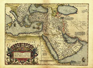
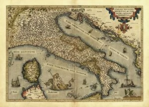
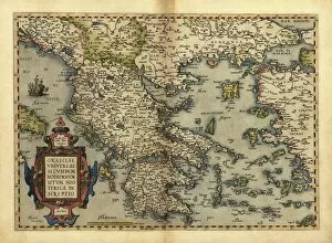
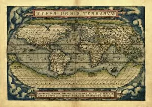
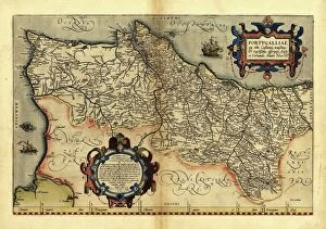
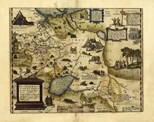
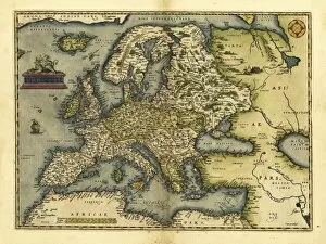
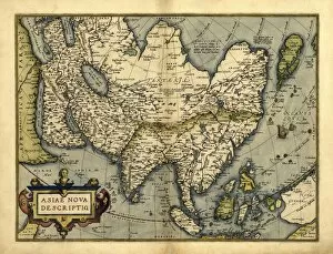
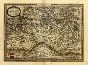
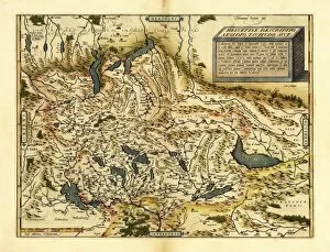
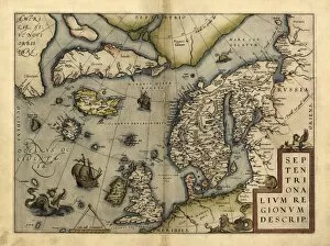
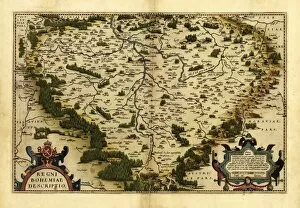
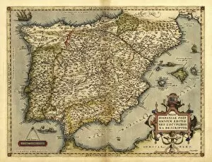
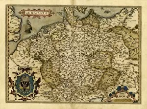
Gilles Coppens de Diest: Mapping the World in 1570 Step into the world of Gilles Coppens de Diest, a renowned cartographer whose intricate maps unveiled the mysteries of various regions during the 16th century. In 1570, he collaborated with Abraham Ortelius to create an extraordinary collection of maps that showcased the diverse corners of our planet. Orteliuss map of Ottoman Empire takes us on a journey through ancient lands, revealing the grandeur and cultural richness that once thrived within its borders. Meanwhile, Orteliuss map of Italy captures the essence of this enchanting country, depicting its iconic cities and breathtaking landscapes. Venturing further eastward, we explore Orteliuss map of Poland which unravels a nation steeped in history and resilience. The intricate details transport us back to an era when Poland flourished as one of Europe's most influential powers. As we move southwards, Orteliuss map Greece invites us to discover its mythical past and architectural wonders. From Athens' majestic Acropolis to Delphi's sacred oracle site - every corner holds stories waiting to be told. Orteliuss world map serves as a testament to human curiosity and exploration. This comprehensive depiction showcases continents interconnected by vast oceans; it reminds us how small our world truly is. Returning closer home, Orteliuss map Holland highlights this prosperous nation's maritime prowess and bustling trade routes. It reflects their indomitable spirit as they navigated uncharted waters towards prosperity. Portugal comes alive in Orteliuss map Portugal - a land known for its seafaring heritage that shaped global history through bold explorations across distant seas. Denmark emerges from Orteliuss map Denmark with tales woven into its picturesque landscapes dotted with castles and charming towns – inviting visitors to immerse themselves in Danish culture. European Russia unfolds before our eyes on Orteliuss Map European Russia – showcasing vast territories, diverse cultures, and the immense power that once emanated from this land.