Fraud Blocker Skip to main content

Gulf Of Mexico Collection

The Gulf of Mexico: A Captivating Blend of History, Natural Beauty

Background imageGulf Of Mexico Collection: Caribbean islands, 1870s

Caribbean islands, 1870s
Map of West Indies and the Caribbean Sea, 1800s. Printed color lithograph

Background imageGulf Of Mexico Collection: Florida, Anna Maria Island, Rod & Reel Pier, Manatee County, Tampa Bay, Gulf Of Mexico

Florida, Anna Maria Island, Rod & Reel Pier, Manatee County, Tampa Bay, Gulf Of Mexico, Beach, Dusk

Background imageGulf Of Mexico Collection: United States, Florida, St Pete Beach, Gulf Of Mexico, Don CeSar Hotel, Pink Palace

United States, Florida, St Pete Beach, Gulf Of Mexico, Don CeSar Hotel, Pink Palace, 1928, National Register Of Historic Places

Background imageGulf Of Mexico Collection: Costa Rica Vector Map

Costa Rica Vector Map
+++

Background imageGulf Of Mexico Collection: Cape Romano sunken domes

Cape Romano sunken domes
sunrise over the sunken domes of Cape Romano. Once a vacation residence but two Hurricanes destroyed the island and so these abandoned buildings slowly wandered into the Gulf of Mexico

Background imageGulf Of Mexico Collection: Ocean currents off the Americas

Ocean currents off the Americas. Satellite-based graphic showing ocean currents (swirling coloured lines) on an Earth globe centred on the Americas

Background imageGulf Of Mexico Collection: Seaport of Galveston, Texas, 1800s

Seaport of Galveston, Texas, 1800s
Galveston bar and roadstead on the Gulf Coast, 1870s. Hand-colored woodcut of a 19th-century illustration

Background imageGulf Of Mexico Collection: EVCW2A-00109

EVCW2A-00109
Admiral David G. Farragut in the rigging during the Battle of Mobile Bay, 1864, American Civil War. Hand-colored photogravure of a W.H. Overend painting

Background imageGulf Of Mexico Collection: 17th century map of the New World

17th century map of the New World

Background imageGulf Of Mexico Collection: The Lesser Antilles or the Windward Islands, with the Eastern part of the Leeward Islands

The Lesser Antilles or the Windward Islands, with the Eastern part of the Leeward Islands
KW205898 The Lesser Antilles or the Windward Islands, with the Eastern part of the Leeward Islands, from Atlas de Toutes les Parties Connues du Globe Terrestre by Guillaume Raynal (1713-96)

Background imageGulf Of Mexico Collection: Sea Oats (Uniola paniculata) growing on sand dunes, Gulf of Mexico, South Padre Island

Sea Oats (Uniola paniculata) growing on sand dunes, Gulf of Mexico, South Padre Island, Texas, USA at sunrise

Background imageGulf Of Mexico Collection: Mississippi Beach at Biloxi Resort, part of the miles of white sands on the Gulf of Mexico coast

Mississippi Beach at Biloxi Resort, part of the miles of white sands on the Gulf of Mexico coast, Mississippi, United States of America, North America

Background imageGulf Of Mexico Collection: Sunshine Skyway Bridge, Tampa Bay, Saint Petersburg, Florida

Sunshine Skyway Bridge, Tampa Bay, Saint Petersburg, Florida

Background imageGulf Of Mexico Collection: Union gunboats sunk in Galveston Bay, 1863

Union gunboats sunk in Galveston Bay, 1863
Rebel attack on Union gunboats at Galveston, Texas, 1863. Hand-colored woodcut of a 19th-century illustration

Background imageGulf Of Mexico Collection: End of US Highway 1 with Mile Zero marker in Key West, Florida, USA

End of US Highway 1 with Mile Zero marker in Key West, Florida, USA

Background imageGulf Of Mexico Collection: Sauroposeidon dinosaurs mating

Sauroposeidon dinosaurs mating. Artwork of male (right) and female (left) Sauroposeidon dinosaurs mating. This sauropod dinosaur lived around 110 million years ago, during the Cretaceous period

Background imageGulf Of Mexico Collection: EXPL2A-00377

EXPL2A-00377
Chart of the West Indies sea depths and land elevations. Printed color lithograph of a 19th-century illustration

Background imageGulf Of Mexico Collection: Battle of Mobile Bay, Civil War, 1864

Battle of Mobile Bay, Civil War, 1864
Farraguts flagship USS " Hartford" colliding with the ironclad CSS " Tennessee" to secure Mobile Bay, 1864. Hand-colored woodcut of a 19th-century illustration

Background imageGulf Of Mexico Collection: Antquie Map of The West Indies

Antquie Map of The West Indies
Vintage map of The West Indies from 1837

Background imageGulf Of Mexico Collection: MAP OF COLONIAL AMERICA. Delisles map of colonial America, 1718, showing the Mississippi

MAP OF COLONIAL AMERICA. Delisles map of colonial America, 1718, showing the Mississippi valley in strikingly accurate detail and the first map to use Texas as a place-name

Background imageGulf Of Mexico Collection: Mexico, ancient map, lithograph, published in 1877

Mexico, ancient map, lithograph, published in 1877
Ancient map of Mexico. Lithograph, published in 1877

Background imageGulf Of Mexico Collection: New and accurate map of the West Indies (colour litho)

New and accurate map of the West Indies (colour litho)
XCF274391 New and accurate map of the West Indies (colour litho) by American School; Private Collection; American, out of copyright

Background imageGulf Of Mexico Collection: USA, Florida, Naples, Naples Pier at Sunset

USA, Florida, Naples, Naples Pier at Sunset

Background imageGulf Of Mexico Collection: USA, Florida, Captiva Dawn

USA, Florida, Captiva Dawn

18th century map, Central America and Gulf of Mexico
5322624 18th century map, Central America and Gulf of Mexico.; (add.info.: 18th century map of Central America and the Gulf of Mexico engraved by Balthasar Ruyter.).

Background imageGulf Of Mexico Collection: Map of Mexico, c.1900 (engraving)

Map of Mexico, c.1900 (engraving)
533250 Map of Mexico, c.1900 (engraving); (add.info.: Map of Mexico, circa 1902, from the 10th edition of Encyclopaedia Britannica.); Encyclopaedia Britannica/UIG.

Background imageGulf Of Mexico Collection: French View of North America, 1762

French View of North America, 1762
2902787 French View of North America, 1762; (add.info.: North America from the Gulf of St. Lawrence to the Gulf of Mexico, west nearly to the Rocky Mountains.); Buyenlarge Archive/UIG.

Background imageGulf Of Mexico Collection: Map of Galveston Bay, Houston and vicinity, c.1900 (engraving)

Map of Galveston Bay, Houston and vicinity, c.1900 (engraving)
532761 Map of Galveston Bay, Houston and vicinity, c.1900 (engraving); (add.info.: Map of Galveston Bay, Houston, circa 1900)

Background imageGulf Of Mexico Collection: Map of eastern Texas, c.1900 (engraving)

Map of eastern Texas, c.1900 (engraving)
533161 Map of eastern Texas, c.1900 (engraving); (add.info.: Map of the eastern part of Texas, circa 1902, from the 10th edition of Encyclopaedia Britannica.); Encyclopaedia Britannica/UIG.

Background imageGulf Of Mexico Collection: Map of western Texas with Galveston, c.1900 (engraving)

Map of western Texas with Galveston, c.1900 (engraving)
533163 Map of western Texas with Galveston, c.1900 (engraving); (add.info.: Map of the western part of Texas with inset map of Galveston Bay, Galveston, Houston and Vicinity, circa 1902)

Background imageGulf Of Mexico Collection: Map of Florida with insets of cities, c.1900 (engraving)

Map of Florida with insets of cities, c.1900 (engraving)
533142 Map of Florida with insets of cities, c.1900 (engraving); (add.info.: Map of Florida, United States, with inset maps of Jacksonville, Tampa, St)

Background imageGulf Of Mexico Collection: Map of Louisiana, c.1900 (engraving)

Map of Louisiana, c.1900 (engraving)
533158 Map of Louisiana, c.1900 (engraving); (add.info.: Map of Louisiana, United States, with inset map of New Orleans and Vicinity, circa 1902)

Background imageGulf Of Mexico Collection: After the Storm

After the Storm
Courtney Crane

Background imageGulf Of Mexico Collection: Ambrosia

Ambrosia
Courtney Crane

Background imageGulf Of Mexico Collection: Ambrosia

Ambrosia
Courtney Crane

Background imageGulf Of Mexico Collection: Brown pelicans rest on pilings off a Naples Beach during an eclipse of the moon

Brown pelicans rest on pilings off a Naples Beach during an eclipse of the moon

Background imageGulf Of Mexico Collection: Wharf office and Commandancia Street wharf, Pensacola, Fla. between 1900 and 1905. Creator: Unknown

Wharf office and Commandancia Street wharf, Pensacola, Fla. between 1900 and 1905. Creator: Unknown
Wharf office and Commandancia Street wharf, Pensacola, Fla. between 1900 and 1905

Background imageGulf Of Mexico Collection: Commandancia and Tarragona Street wharves, Pensacola, Fla. between 1900 and 1905. Creator: Unknown

Commandancia and Tarragona Street wharves, Pensacola, Fla. between 1900 and 1905. Creator: Unknown
Commandancia and Tarragona Street wharves, Pensacola, Fla. between 1900 and 1905

Background imageGulf Of Mexico Collection: Commandancia Street wharf, Pensacola, Fla. between 1900 and 1905. Creator: Unknown

Commandancia Street wharf, Pensacola, Fla. between 1900 and 1905. Creator: Unknown
Commandancia Street wharf, Pensacola, Fla. between 1900 and 1905

Background imageGulf Of Mexico Collection: Veracruz, Mexico, between 1914 and 1917. Creator: Harris & Ewing

Veracruz, Mexico, between 1914 and 1917. Creator: Harris & Ewing. Veracruz, Mexico, between 1914 and 1917
Veracruz, Mexico, between 1914 and 1917

Background imageGulf Of Mexico Collection: Veracruz, Mexico, between 1914 and 1917. Creator: Harris & Ewing

Veracruz, Mexico, between 1914 and 1917. Creator: Harris & Ewing. Veracruz, Mexico, between 1914 and 1917
Veracruz, Mexico, between 1914 and 1917

Background imageGulf Of Mexico Collection: Veracruz, Mexico?, between 1914 and 1917. Creator: Harris & Ewing

Veracruz, Mexico?, between 1914 and 1917. Creator: Harris & Ewing. Veracruz, Mexico?, between 1914 and 1917
Veracruz, Mexico?, between 1914 and 1917

Background imageGulf Of Mexico Collection: Veracruz, Mexico, between 1914 and 1917. Creator: Harris & Ewing

Veracruz, Mexico, between 1914 and 1917. Creator: Harris & Ewing. Veracruz, Mexico, between 1914 and 1917
Veracruz, Mexico, between 1914 and 1917

Background imageGulf Of Mexico Collection: Veracruz, Mexico, between 1914 and 1917. Creator: Harris & Ewing

Veracruz, Mexico, between 1914 and 1917. Creator: Harris & Ewing. Veracruz, Mexico, between 1914 and 1917
Veracruz, Mexico, between 1914 and 1917

Background imageGulf Of Mexico Collection: Net fishing on the Gulf of Mexico, Pass Christian, Mississippi, 1937. Creator: Dorothea Lange

Net fishing on the Gulf of Mexico, Pass Christian, Mississippi, 1937. Creator: Dorothea Lange
Net fishing on the Gulf of Mexico. Pass Christian, Mississippi

Background imageGulf Of Mexico Collection: Path to the beach

Path to the beach
Melanie Viola

Background imageGulf Of Mexico Collection: Calmness on the beach

Calmness on the beach
Melanie Viola


All Professionally Made to Order for Quick Shipping

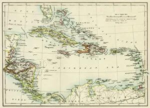
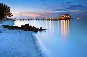
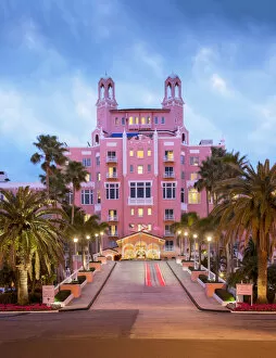
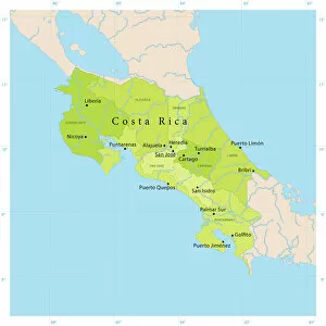
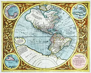
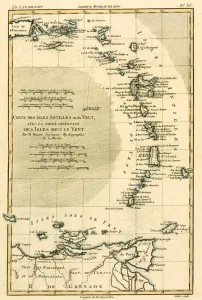
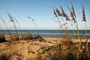
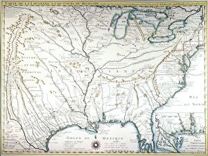
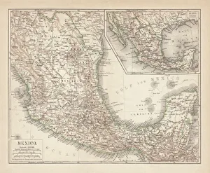
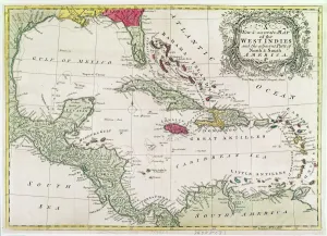
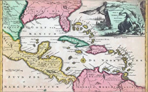
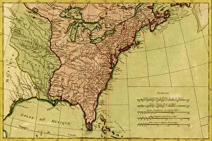
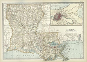
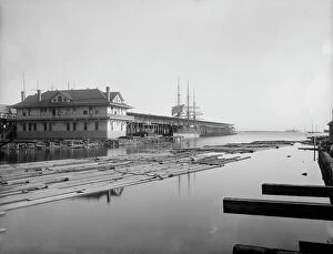
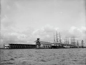
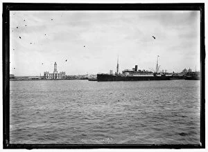
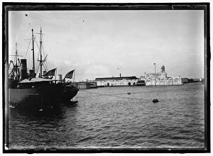
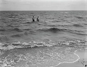
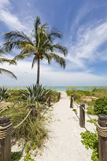
The Gulf of Mexico: A Captivating Blend of History, Natural Beauty, and Coastal Delights Step into a world where the Caribbean islands meet the United States in the enchanting Gulf of Mexico. Since the 1870s, this stunning body of water has been a haven for travelers seeking paradise on earth. In Florida's St Pete Beach, nestled along the shores of the Gulf Of Mexico, lies an architectural gem known as Don CeSar Hotel or Pink Palace. Its grandeur is reminiscent of a bygone era when elegance reigned supreme. Venturing further south to Costa Rica reveals a vector map showcasing its proximity to this magnificent gulf. And off its coast lie Cape Romano sunken domes - mysterious structures that have captured imaginations for years. Travel back in time to Galveston, Texas during the 1800s when it served as a bustling seaport. The echoes of history still resonate through its streets and harbor today. Exploring ocean currents off the Americas unveils nature's intricate dance within these azure waters. EVCW2A-00109 captures this captivating phenomenon with scientific precision. Discovering The Lesser Antilles or Windward Islands offers glimpses into both their natural beauty and cultural heritage. These islands are complemented by Eastern part Leeward Islands - truly an archipelago worth exploring. Witness sea oats gracefully swaying atop sand dunes on South Padre Island – an idyllic scene that epitomizes tranquility along the Gulf Coastline. Delve deeper into history with a glance at a 17th-century map depicting New World discoveries – reminding us how exploration shaped our understanding of this vast region. For those seeking relaxation amidst white sands, Mississippi Beach at Biloxi Resort beckons visitors to unwind and soak up endless miles of pristine coastline along the Gulf Of Mexico coast. Finally, marvel at engineering prowess as you traverse Sunshine Skyway Bridge over Tampa Bay, connecting Saint Petersburg to the rest of Florida.