Fraud Blocker Skip to main content

Historical Map Collection

Step back in time with these captivating historical maps

Background imageHistorical Map Collection: Lancashire Historical John Speed 1610 Map

Lancashire Historical John Speed 1610 Map
A reproduction of John Speeds historical map of the county of Lancashire. Originally published as part of his atlas called The Theatre of the Empire of Great Britain in 1610

Background imageHistorical Map Collection: Map of Europe at the time of the Third Crusade, 1190, from Historical Atlas

Map of Europe at the time of the Third Crusade, 1190, from Historical Atlas
KW342818 Map of Europe at the time of the Third Crusade, 1190, from Historical Atlas, published by W. & A.K. Johnston Limited, 1911 (colour litho) by English School

Background imageHistorical Map Collection: Kent Historical John Speed 1610 Map

Kent Historical John Speed 1610 Map
A reproduction of John Speeds historical map of the county of Kent. Originally published as part of his atlas called The Theatre of the Empire of Great Britain in 1610

Background imageHistorical Map Collection: Yorkshire Historical John Speed 1610 Map

Yorkshire Historical John Speed 1610 Map
A reproduction of John Speeds historical map of the county of Yorkshire. Originally published as part of his atlas called The Theatre of the Empire of Great Britain in 1610

Background imageHistorical Map Collection: Somerset Historical John Speed 1610 Map

Somerset Historical John Speed 1610 Map
A reproduction of John Speeds historical map of the county of Somerset. Originally published as part of his atlas called The Theatre of the Empire of Great Britain in 1610

Background imageHistorical Map Collection: Pembrokeshire Historical John Speed 1610 Map

Pembrokeshire Historical John Speed 1610 Map
A reproduction of John Speeds historical map of the county of Pembrokeshire. Originally published as part of his atlas called The Theatre of the Empire of Great Britain in 1610

Background imageHistorical Map Collection: Oxfordshire Historical John Speed 1610 Map

Oxfordshire Historical John Speed 1610 Map
A reproduction of John Speeds historical map of the county of Oxfordshire. Originally published as part of his atlas called The Theatre of the Empire of Great Britain in 1610

Background imageHistorical Map Collection: Yorkshire West Riding Historical John Speed 1610 Map

Yorkshire West Riding Historical John Speed 1610 Map
A reproduction of John Speeds historical map of the county of West Yorkshire. Originally published as part of his atlas called The Theatre of the Empire of Great Britain in 1610

Background imageHistorical Map Collection: Lincolnshire Historical John Speed 1610 Map

Lincolnshire Historical John Speed 1610 Map
A reproduction of John Speeds historical map of the county of Lincolnshire. Originally published as part of his atlas called The Theatre of the Empire of Great Britain in 1610

Background imageHistorical Map Collection: Northumberland Historical John Speed 1610 Map

Northumberland Historical John Speed 1610 Map
A reproduction of John Speeds historical map of the county of Northumberland. Originally published as part of his atlas called The Theatre of the Empire of Great Britain in 1610

Background imageHistorical Map Collection: Nottinghamshire Historical John Speed 1610 Map

Nottinghamshire Historical John Speed 1610 Map
A reproduction of John Speeds historical map of the county of Nottinghamshire. Originally published as part of his atlas called The Theatre of the Empire of Great Britain in 1610

Background imageHistorical Map Collection: Cornwall Historical John Speed 1610 Map

Cornwall Historical John Speed 1610 Map
A reproduction of John Speeds historical map of the county of Cornwall. Originally published as part of his atlas called The Theatre of the Empire of Great Britain in 1610

Background imageHistorical Map Collection: Sussex Historical John Speed 1610 Map

Sussex Historical John Speed 1610 Map
A reproduction of John Speeds historical map of the county of Sussex. Originally published as part of his atlas called The Theatre of the Empire of Great Britain in 1610

Background imageHistorical Map Collection: Surrey Historical John Speed 1610 Map

Surrey Historical John Speed 1610 Map
A reproduction of John Speeds historical map of the county of Surrey. Originally published as part of his atlas called The Theatre of the Empire of Great Britain in 1610

Background imageHistorical Map Collection: Isle of Wight Historical John Speed 1610 Map

Isle of Wight Historical John Speed 1610 Map
A reproduction of John Speeds historical map of the county of Isle of Wight. Originally published as part of his atlas called The Theatre of the Empire of Great Britain in 1610

Background imageHistorical Map Collection: Leicestershire Historical John Speed 1610 Map

Leicestershire Historical John Speed 1610 Map
A reproduction of John Speeds historical map of the county of Leicestershire. Originally published as part of his atlas called The Theatre of the Empire of Great Britain in 1610

Background imageHistorical Map Collection: Norfolk Historical John Speed 1610 Map

Norfolk Historical John Speed 1610 Map
A reproduction of John Speeds historical map of the county of Norfolk. Originally published as part of his atlas called The Theatre of the Empire of Great Britain in 1610

Background imageHistorical Map Collection: Suffolk Historical John Speed 1610 Map

Suffolk Historical John Speed 1610 Map
A reproduction of John Speeds historical map of the county of Suffolk. Originally published as part of his atlas called The Theatre of the Empire of Great Britain in 1610

Background imageHistorical Map Collection: Rutland Historical John Speed 1610 Map

Rutland Historical John Speed 1610 Map
A reproduction of John Speeds historical map of the county of Rutland. Originally published as part of his atlas called The Theatre of the Empire of Great Britain in 1610

Background imageHistorical Map Collection: Devon Historical John Speed 1610 Map

Devon Historical John Speed 1610 Map
A reproduction of John Speeds historical map of the county of Devon. Originally published as part of his atlas called The Theatre of the Empire of Great Britain in 1610

Background imageHistorical Map Collection: Durham Historical John Speed 1610 Map

Durham Historical John Speed 1610 Map
A reproduction of John Speeds historical map of the county of Durham. Originally published as part of his atlas called The Theatre of the Empire of Great Britain in 1610

Background imageHistorical Map Collection: Flintshire Historical John Speed 1610 Map

Flintshire Historical John Speed 1610 Map
A reproduction of John Speeds historical map of the county of Flintshire. Originally published as part of his atlas called The Theatre of the Empire of Great Britain in 1610

Background imageHistorical Map Collection: Cambridgeshire Historical John Speed 1610 Map

Cambridgeshire Historical John Speed 1610 Map
A reproduction of John Speeds historical map of the county of Cambridgeshire. Originally published as part of his atlas called The Theatre of the Empire of Great Britain in 1610

Background imageHistorical Map Collection: Gloucestershire Historical John Speed 1610 Map

Gloucestershire Historical John Speed 1610 Map
A reproduction of John Speeds historical map of the county of Gloucestershire. Originally published as part of his atlas called The Theatre of the Empire of Great Britain in 1610

Background imageHistorical Map Collection: Map of Britain in 593, printed by Stanfords Geographical Establishment (litho)

Map of Britain in 593, printed by Stanfords Geographical Establishment (litho)
STC347552 Map of Britain in 593, printed by Stanfords Geographical Establishment (litho) by English School; Private Collection; (add.info)

Background imageHistorical Map Collection: Middlesex Historical John Speed 1610 Map

Middlesex Historical John Speed 1610 Map
A reproduction of John Speeds historical map of the county of Middlesex. Originally published as part of his atlas called The Theatre of the Empire of Great Britain in 1610

Background imageHistorical Map Collection: Worcestershire Historical John Speed 1610 Map

Worcestershire Historical John Speed 1610 Map
A reproduction of John Speeds historical map of the county of Worcestershire. Originally published as part of his atlas called The Theatre of the Empire of Great Britain in 1610

Background imageHistorical Map Collection: Yorkshire North & East Riding Historical John Speed 1610 Map

Yorkshire North & East Riding Historical John Speed 1610 Map
A reproduction of John Speeds historical map of the county of North Yorkshire & the East Riding. Originally published as part of his atlas called The Theatre of the Empire of Great Britain in 1610

Background imageHistorical Map Collection: Northamptonshire Historical John Speed 1610 Map

Northamptonshire Historical John Speed 1610 Map
A reproduction of John Speeds historical map of the county of Northamptonshire. Originally published as part of his atlas called The Theatre of the Empire of Great Britain in 1610

Background imageHistorical Map Collection: Shropshire Historical John Speed 1610 Map

Shropshire Historical John Speed 1610 Map
A reproduction of John Speeds historical map of the county of Shropshire. Originally published as part of his atlas called The Theatre of the Empire of Great Britain in 1610

Background imageHistorical Map Collection: Buckinghamshire Historical John Speed 1610 Map

Buckinghamshire Historical John Speed 1610 Map
A reproduction of John Speeds historical map of the county of Buckinghamshire. Originally published as part of his atlas called The Theatre of the Empire of Great Britain in 1610

Background imageHistorical Map Collection: Derbyshire Historical John Speed 1610 Map

Derbyshire Historical John Speed 1610 Map
A reproduction of John Speeds historical map of the county of Derbyshire. Originally published as part of his atlas called The Theatre of the Empire of Great Britain in 1610

Background imageHistorical Map Collection: Cheshire Historical John Speed 1610 Map

Cheshire Historical John Speed 1610 Map
A reproduction of John Speeds historical map of the county of Cheshire. Originally published as part of his atlas called The Theatre of the Empire of Great Britain in 1610

Background imageHistorical Map Collection: Glamorgan Historical John Speed 1610 Map

Glamorgan Historical John Speed 1610 Map
A reproduction of John Speeds historical map of the county of Glamorgan. Originally published as part of his atlas called The Theatre of the Empire of Great Britain in 1610

Background imageHistorical Map Collection: Dorset Historical John Speed 1610 Map

Dorset Historical John Speed 1610 Map
A reproduction of John Speeds historical map of the county of Dorset. Originally published as part of his atlas called The Theatre of the Empire of Great Britain in 1610

Background imageHistorical Map Collection: Westmoreland Historical John Speed 1610 Map

Westmoreland Historical John Speed 1610 Map
A reproduction of John Speeds historical map of the county of Westmoreland. Originally published as part of his atlas called The Theatre of the Empire of Great Britain in 1610

Background imageHistorical Map Collection: Warwickshire Historical John Speed 1610 Map

Warwickshire Historical John Speed 1610 Map
A reproduction of John Speeds historical map of the county of Warwickshire. Originally published as part of his atlas called The Theatre of the Empire of Great Britain in 1610

Background imageHistorical Map Collection: Wiltshire Historical John Speed 1610 Map

Wiltshire Historical John Speed 1610 Map
A reproduction of John Speeds historical map of the county of Wiltshire. Originally published as part of his atlas called The Theatre of the Empire of Great Britain in 1610

Background imageHistorical Map Collection: Munster Historical John Speed 1610 Map

Munster Historical John Speed 1610 Map
A reproduction of John Speeds historical map of the county of Munster. Originally published as part of his atlas called The Theatre of the Empire of Great Britain in 1610

Background imageHistorical Map Collection: Montgomeryshire Historical John Speed 1610 Map

Montgomeryshire Historical John Speed 1610 Map
A reproduction of John Speeds historical map of the county of Montgomeryshire. Originally published as part of his atlas called The Theatre of the Empire of Great Britain in 1610

Background imageHistorical Map Collection: Monmouthshire Historical John Speed 1610 Map

Monmouthshire Historical John Speed 1610 Map
A reproduction of John Speeds historical map of the county of Monmouthshire. Originally published as part of his atlas called The Theatre of the Empire of Great Britain in 1610

Background imageHistorical Map Collection: Merionethshire Historical John Speed 1610 Map

Merionethshire Historical John Speed 1610 Map
A reproduction of John Speeds historical map of the county of Merionethshire. Originally published as part of his atlas called The Theatre of the Empire of Great Britain in 1610

Background imageHistorical Map Collection: Leinster Historical John Speed 1610 Map

Leinster Historical John Speed 1610 Map
A reproduction of John Speeds historical map of the county of Leinster. Originally published as part of his atlas called The Theatre of the Empire of Great Britain in 1610

Background imageHistorical Map Collection: Staffordshire Historical John Speed 1610 Map

Staffordshire Historical John Speed 1610 Map
A reproduction of John Speeds historical map of the county of Staffordshire. Originally published as part of his atlas called The Theatre of the Empire of Great Britain in 1610

Background imageHistorical Map Collection: Ulster Historical John Speed 1610 Map

Ulster Historical John Speed 1610 Map
A reproduction of John Speeds historical map of the county of Ulster. Originally published as part of his atlas called The Theatre of the Empire of Great Britain in 1610

Background imageHistorical Map Collection: Radnorshire Historical John Speed 1610 Map

Radnorshire Historical John Speed 1610 Map
A reproduction of John Speeds historical map of the county of Radnorshire. Originally published as part of his atlas called The Theatre of the Empire of Great Britain in 1610

Background imageHistorical Map Collection: Cardiganshire Historical John Speed 1610 Map

Cardiganshire Historical John Speed 1610 Map
A reproduction of John Speeds historical map of the county of Cardiganshire. Originally published as part of his atlas called The Theatre of the Empire of Great Britain in 1610

Background imageHistorical Map Collection: Caernarfonshire Historical John Speed 1610 Map

Caernarfonshire Historical John Speed 1610 Map
A reproduction of John Speeds historical map of the county of Caernarfonshire. Originally published as part of his atlas called The Theatre of the Empire of Great Britain in 1610


All Professionally Made to Order for Quick Shipping

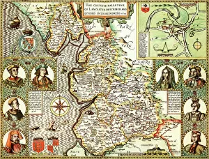
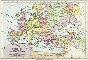
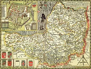
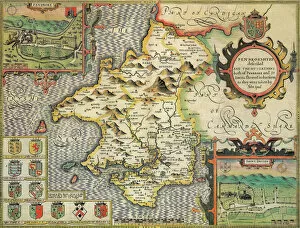
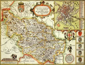
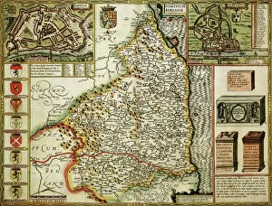
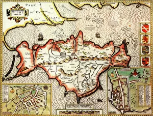
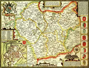
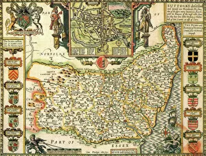
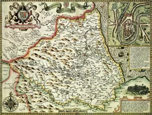
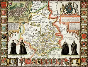
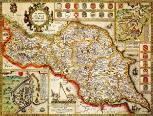
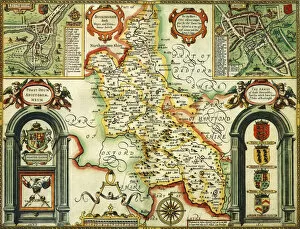
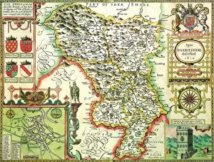
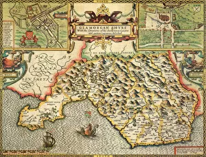
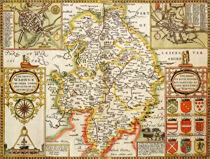
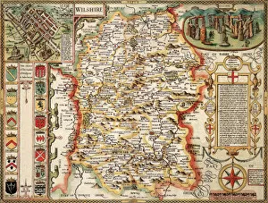
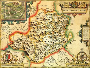
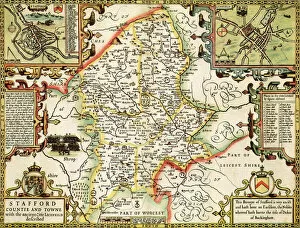
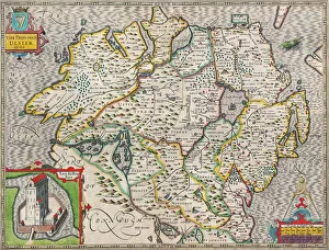
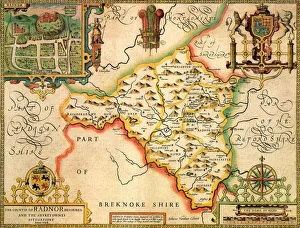
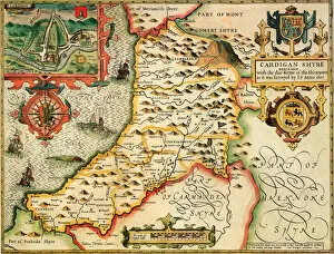
Step back in time with these captivating historical maps. From Lancashire to Kent, Yorkshire to Somerset, each map offers a glimpse into the past and allows us to explore the rich history of these regions. The Lancashire Historical John Speed 1610 Map takes us on a journey through this county, revealing its intricate details and landmarks from centuries ago. Meanwhile, the Map of Europe at the time of the Third Crusade in 1190 transports us to an era filled with knights, castles, and epic battles for control over holy lands. Delving further into England's history, we encounter fascinating maps such as the Kent Historical John Speed 1610 Map and Yorkshire West Riding Historical John Speed 1610 Map which showcase these areas' unique features during that period. As we move southwards, Lincolnshire Historical John Speed 1610 Map sheds light on this county's past while Nottinghamshire Historical John Speed 1610 Map unveils its hidden stories waiting to be discovered. Cornwall's charm comes alive in Cornwall Historical John Speed 1610 Map while Sussex reveals its secrets through Sussex Historical John Speed 1610 Map. Pembrokeshire captivates our imagination with Pembrokeshire Historical John Speed 1610 Map showcasing its beauty and heritage. Lastly, Oxfordshire beckons us with Oxfordshire Historical John Speed 1610 map inviting exploration of one of England's most prestigious university cities. These historical maps not only serve as windows into bygone eras but also remind us of how our world has evolved over time. They offer valuable insights into geography, culture, and societal structures that have shaped our present-day landscapes. So take a step back in time and let your curiosity guide you through these remarkable historical treasures.