Fraud Blocker Skip to main content

Objects Equipment Collection

"Journey through time and space with these captivating objects of history and exploration

Background imageObjects Equipment Collection: Map of Cyprus

Map of Cyprus
Vintage 19th Century map of Cyprus in the eastern Mediterranean Sea

Background imageObjects Equipment Collection: Antquie Map of Italy

Antquie Map of Italy
Vintage map of Italy fron 1837

Background imageObjects Equipment Collection: Map of Hull

Map of Hull
Vintage map from 1880 of Hull in the East Riding of Yorkshire, England. The city of Hull has served as market town, military supply port, trading hub, fishing and whaling centre

Background imageObjects Equipment Collection: 17th century city, plan of Augsburg, Germany

17th century city, plan of Augsburg, Germany
Typical fortifications and references. Rich in details, beautifully aged paperPublished by J. Stockdale, Piccadilly 1800

Background imageObjects Equipment Collection: Papyrus

Papyrus
Egyptian PapayrusMore of my photos:

Background imageObjects Equipment Collection: Vintage Map of the World

Vintage Map of the World
Vintage map of the world from 1837

Background imageObjects Equipment Collection: Map of Pamlico and Albemarle Sounds

Map of Pamlico and Albemarle Sounds
Vintage engraving from 1863 of a map of Map of Pamlico and Albemarle Sounds at the time of the American Civil War

Background imageObjects Equipment Collection: Antquie Map of The West Indies

Antquie Map of The West Indies
Vintage map of The West Indies from 1837

Background imageObjects Equipment Collection: Antquie Map of Prussia

Antquie Map of Prussia
Vintage map of Prussia from 1837

Background imageObjects Equipment Collection: Battle of Belmont

Battle of Belmont
Vintage engraving from 1863 of a map of the Battle of Belmont which was fought on November 7, 1861, in Mississippi County, Missouri. It was the first combat test in the American Civil War for Brig

Background imageObjects Equipment Collection: Battle of Big Bethel

Battle of Big Bethel
Vintage engraving from 1863 of a map of the Battle of Big Bethel also known as the Battle of Bethel Church or Great Bethel was an American Civil War battle that took place on June 10, 1861

Background imageObjects Equipment Collection: Blockade of Boston

Blockade of Boston
Vintage engraving from 1861 showing the Plan of the Blockade of Boston during the American Revolutionary War

Background imageObjects Equipment Collection: Old Testament Map

Old Testament Map
Vintage biblical map from 1879 showing the gentile countries and nations of the Old Testament

Background imageObjects Equipment Collection: Map of South America 19th Century

Map of South America 19th Century
Vintage map of South America from the 19th Century

Background imageObjects Equipment Collection: Antique map of Australia and New Zealand

Antique map of Australia and New Zealand
Vintage map of Australia and New Zealand in 1861

Background imageObjects Equipment Collection: Map of Alderney and the Casquets

Map of Alderney and the Casquets
" Vintage map from 1880 of Alderney and the Casquets. Alderney is the most northerly of the Channel Islands. It is part of the Bailiwick of Guernsey, a British Crown dependency

Background imageObjects Equipment Collection: Map of Portland

Map of Portland
" Vintage map from 1880 of Portland a limestone tombolo or tied island, 6 kilometres long by 2.4 kilometres wide, in the English Channel."

Background imageObjects Equipment Collection: Map of Jersey

Map of Jersey
" Vintage engraving from 1880 of Jersey a British Crown Dependency off the coast of Normandy, France. As well as the island of Jersey itself

Background imageObjects Equipment Collection: Henry VIIIs warship

Henry VIIIs warship
Vintage engraving from 1876 from an orginal by Holbain. A warship of Henry VIII King of England leaves Dover on route to France

Background imageObjects Equipment Collection: Coat of Arms

Coat of Arms
Vintage engraving by Albrecht DArer c.1513 showing a coat of arms

Background imageObjects Equipment Collection: Antique Map of the Persian Empire

Antique Map of the Persian Empire
Antique Map from 1862 of the Persian Empire, the time of Alexander the Great. Maps text is written in Latin

Background imageObjects Equipment Collection: Battle of Bull Run

Battle of Bull Run
Vintage engraving from 1863 of a map of Bull Run and its environs at the time of the American Civil War. The First Battle of Bull Run

Background imageObjects Equipment Collection: Battle of Port Royal

Battle of Port Royal
Vintage engraving from 1863 of a map of the Battle of Port Royal which was one of the earliest amphibious operations of the American Civil War

Background imageObjects Equipment Collection: Antquie Map of South America

Antquie Map of South America
Vintage map of South America from 1837

Background imageObjects Equipment Collection: Map of Ancient Rome

Map of Ancient Rome
Vintage engraving showing a plan of Ancient Rome

Background imageObjects Equipment Collection: Fort Monroe and its environs

Fort Monroe and its environs
Vintage engraving from 1863 of a map of Fort Monroe and its environs. Fort Monroe played an important role in the American Civil War

Background imageObjects Equipment Collection: Antique Map of the World

Antique Map of the World
Vintage map of the World from 1884

Background imageObjects Equipment Collection: Missouri Campaigns

Missouri Campaigns
Vintage engraving from 1863 of a map of the Missouri Campaigns from the time of the American Civil War

Background imageObjects Equipment Collection: Vintage Map of New York

Vintage Map of New York at the beginning of the 18th Century. from 1880


All Professionally Made to Order for Quick Shipping

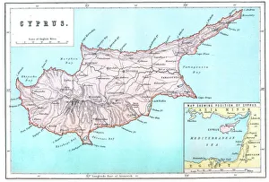
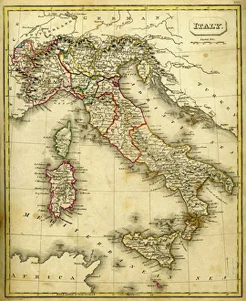
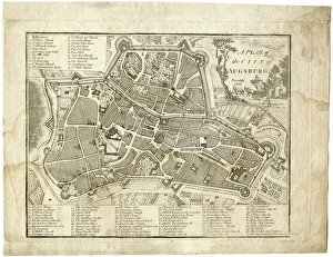
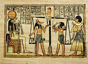
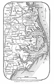
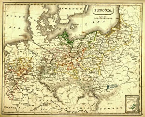
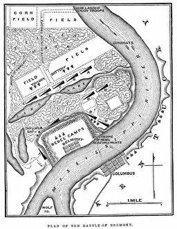
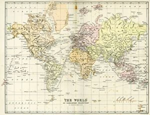
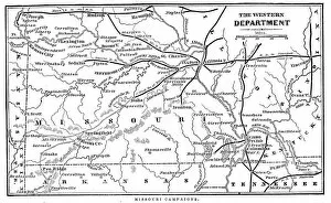
"Journey through time and space with these captivating objects of history and exploration. 🌍✨ Discover the enchanting island of Cyprus with this intricate map, guiding you through its hidden gems and rich culture. Uncover the secrets of Italy's past as you explore an antique map that showcases the country's historical landmarks and breathtaking landscapes. Dive into the maritime history of Hull with a detailed map that traces its evolution from a bustling port city to a modern hub of trade. Step back in time to 17th century Augsburg, Germany, as you unravel the intricacies of its urban planning through a fascinating city plan. Delve into ancient knowledge preserved on delicate papyrus scrolls, offering glimpses into civilizations long gone but not forgotten. Embark on an adventure across continents with a vintage map depicting our world as it was known centuries ago – marvel at how borders have shifted over time. Navigate the waters surrounding Pamlico and Albemarle Sounds using an intriguing map that reveals their geographical features and historical significance. Immerse yourself in Caribbean allure by exploring an antique map showcasing The West Indies' vibrant islands, each steeped in unique cultural heritage. Trace Prussia's storied past through an exquisite antique map, capturing both its grandeur and tumultuous history within its borders. Relive pivotal moments in American history like never before: witness the Battle of Belmont or experience the Blockade of Boston firsthand. Witness bravery unfold during the Battle of Big Bethel – let this object transport you back to a defining moment in Civil War history. " Embark on a visual journey filled with intrigue, nostalgia, and tales waiting to be discovered.