Fraud Blocker Skip to main content

Ols Antique Map Collection

"Exploring the World Through Old Antique Maps

Background imageOls Antique Map Collection: 1768, James Craig Map of New Town, Edinburgh, Scotland, First Plan of New Town, topography

1768, James Craig Map of New Town, Edinburgh, Scotland, First Plan of New Town, topography
1768, James Craig Map of New Town, Edinburgh, Scotland, First Plan of New Town

Background imageOls Antique Map Collection: 1794, Delisle Map of Southern Ancient Greece, Greeks Isles, and Crete, topography

1794, Delisle Map of Southern Ancient Greece, Greeks Isles, and Crete, topography
1794, Delisle Map of Southern Ancient Greece, Greeks Isles, and Crete

Background imageOls Antique Map Collection: 1886, Telescopic View and Map of the Moon, topography, cartography, geography, land

1886, Telescopic View and Map of the Moon, topography, cartography, geography, land
1886, Telescopic View and Map of the Moon

Background imageOls Antique Map Collection: 1865, Spruner Map of Greece, Macedonia and Thrace before the Peloponnesian War. topography

1865, Spruner Map of Greece, Macedonia and Thrace before the Peloponnesian War. topography
1865, Spruner Map of Greece, Macedonia and Thrace before the Peloponnesian War

Background imageOls Antique Map Collection: 1658, Visscher Map of North America and South America, topography, cartography, geography

1658, Visscher Map of North America and South America, topography, cartography, geography
1658, Visscher Map of North America and South America

Background imageOls Antique Map Collection: 1855, Colton Map of Scandinavia, Norway, Sweden, Finland, topography, cartography

1855, Colton Map of Scandinavia, Norway, Sweden, Finland, topography, cartography
1855, Colton Map of Scandinavia, Norway, Sweden, Finland

Background imageOls Antique Map Collection: 1855, Colton Map of Persia, Afghanistan, and Arabia, topography, cartography, geography

1855, Colton Map of Persia, Afghanistan, and Arabia, topography, cartography, geography
1855, Colton Map of Persia, Afghanistan, and Arabia

Background imageOls Antique Map Collection: 1848, Crutchley Pocket Map or Plan of London, England, topography, cartography, geography

1848, Crutchley Pocket Map or Plan of London, England, topography, cartography, geography
1848, Crutchley Pocket Map or Plan of London, England

Background imageOls Antique Map Collection: 1818, Pinkerton Map of the British Isles, England, Scotland, Ireland, John Pinkerton

1818, Pinkerton Map of the British Isles, England, Scotland, Ireland, John Pinkerton, 1758 - 1826, Scottish antiquarian, cartographer, UK

Background imageOls Antique Map Collection: 1864, Johnson Map of Washington, Oregon, and Idaho, topography, cartography, geography

1864, Johnson Map of Washington, Oregon, and Idaho, topography, cartography, geography
1864, Johnson Map of Washington, Oregon, and Idaho

Background imageOls Antique Map Collection: 1706, De La Feuille Map of Europe, topography, cartography, geography, land, illustration

1706, De La Feuille Map of Europe, topography, cartography, geography, land, illustration
1706, De La Feuille Map of Europe

Background imageOls Antique Map Collection: 1750, Homann Heirs Map of Poland, topography, cartography, geography, land, illustration

1750, Homann Heirs Map of Poland, topography, cartography, geography, land, illustration
1750, Homann Heirs Map of Poland

Background imageOls Antique Map Collection: 1890, Bacon Travelers Pocket Map of London, England, topography, cartography

1890, Bacon Travelers Pocket Map of London, England, topography, cartography
1890, Bacon Travelers Pocket Map of London, England

Background imageOls Antique Map Collection: 1865, Spruner Map of Israel, Canaan, or Palestine in Ancient Times, topography, cartography

1865, Spruner Map of Israel, Canaan, or Palestine in Ancient Times, topography, cartography
1865, Spruner Map of Israel, Canaan, or Palestine in Ancient Times

Background imageOls Antique Map Collection: 1570, Ortelius Map of Asia, first edition, Abraham Ortelius, also Orthellius, 1527 - 1598

1570, Ortelius Map of Asia, first edition, Abraham Ortelius, also Orthellius, 1527 - 1598, Flemish, Netherlandish cartographer and geographer

Background imageOls Antique Map Collection: 1818, Pinkerton Map of Chile, John Pinkerton, 1758 - 1826, Scottish antiquarian, cartographer

1818, Pinkerton Map of Chile, John Pinkerton, 1758 - 1826, Scottish antiquarian, cartographer, UK

Background imageOls Antique Map Collection: 1784, Bocage Map of the City of Athens in Ancient Greece, topography, cartography

1784, Bocage Map of the City of Athens in Ancient Greece, topography, cartography
1784, Bocage Map of the City of Athens in Ancient Greece

Background imageOls Antique Map Collection: 1865, Spruner Map of the British Isles, England, Scotland, Ireland, topography, cartography

1865, Spruner Map of the British Isles, England, Scotland, Ireland, topography, cartography
1865, Spruner Map of the British Isles, England, Scotland, Ireland

Background imageOls Antique Map Collection: 1839, Bradford Map of New York City, New York, topography, cartography, geography

1839, Bradford Map of New York City, New York, topography, cartography, geography
1839, Bradford Map of New York City, New York

Background imageOls Antique Map Collection: 1770, Bonne Map of China, Korea, Japan and Formosa, Rigobert Bonne 1727 - 1794, one

1770, Bonne Map of China, Korea, Japan and Formosa, Rigobert Bonne 1727 - 1794, one of the most important cartographers of the late 18th century

Background imageOls Antique Map Collection: 1683, Mortier Map of North America, the West Indies, and the Atlantic Ocean, topography

1683, Mortier Map of North America, the West Indies, and the Atlantic Ocean, topography
1683, Mortier Map of North America, the West Indies, and the Atlantic Ocean

Background imageOls Antique Map Collection: 1855, Colton Map of Minnesota, topography, cartography, geography, land, illustration

1855, Colton Map of Minnesota, topography, cartography, geography, land, illustration
1855, Colton Map of Minnesota

Background imageOls Antique Map Collection: 1852, Levasseur Map of Asia, topography, cartography, geography, land, illustration

1852, Levasseur Map of Asia, topography, cartography, geography, land, illustration
1852, Levasseur Map of Asia

Background imageOls Antique Map Collection: 1863, Cassells Dispatch Atlas Map of Taiwan, Formosa and the Hainan Coast of China

1863, Cassells Dispatch Atlas Map of Taiwan, Formosa and the Hainan Coast of China

Background imageOls Antique Map Collection: 1835, S. D. U. K. City Map or Plan of Amsterdam, The Netherlands, topography, cartography

1835, S. D. U. K. City Map or Plan of Amsterdam, The Netherlands, topography, cartography
1835, S.D.U.K. City Map or Plan of Amsterdam, The Netherlands

Background imageOls Antique Map Collection: 1818, Pinkerton Map of Persia, Iran, Afghanistan, John Pinkerton, 1758 - 1826, Scottish

1818, Pinkerton Map of Persia, Iran, Afghanistan, John Pinkerton, 1758 - 1826, Scottish antiquarian, cartographer, UK

Background imageOls Antique Map Collection: 1855, Colton Map of Scotland, topography, cartography, geography, land, illustration

1855, Colton Map of Scotland, topography, cartography, geography, land, illustration
1855, Colton Map of Scotland

Background imageOls Antique Map Collection: 1801, Cary Map of China and Korea, John Cary, 1754 - 1835, English cartographer, topography

1801, Cary Map of China and Korea, John Cary, 1754 - 1835, English cartographer, topography
1801, Cary Map of China and Korea, John Cary, 1754 - 1835, English cartographer

Background imageOls Antique Map Collection: 1772, Bonne Map of Scotland, Rigobert Bonne 1727 - 1794, one of the most important

1772, Bonne Map of Scotland, Rigobert Bonne 1727 - 1794, one of the most important cartographers of the late 18th century

Background imageOls Antique Map Collection: 1864, Garnier Map of Pairs, France w-Monuments, topography, cartography, geography

1864, Garnier Map of Pairs, France w-Monuments, topography, cartography, geography
1864, Garnier Map of Pairs, France w-Monuments

Background imageOls Antique Map Collection: 1852, Levasseur Map of the Department De Maine et Loire, France, topography, cartography

1852, Levasseur Map of the Department De Maine et Loire, France, topography, cartography
1852, Levasseur Map of the Department De Maine et Loire, France

Background imageOls Antique Map Collection: 1801, Cary Map of Scotland, 4 Sheets, John Cary, 1754 - 1835, English cartographer

1801, Cary Map of Scotland, 4 Sheets, John Cary, 1754 - 1835, English cartographer

Background imageOls Antique Map Collection: 1843, Monaldini Case Map of Rome, Italy, topography, cartography, geography, land

1843, Monaldini Case Map of Rome, Italy, topography, cartography, geography, land
1843, Monaldini Case Map of Rome, Italy

Background imageOls Antique Map Collection: 1892, Scientific American Map and View of New York City, topography, cartography

1892, Scientific American Map and View of New York City, topography, cartography
1892, Scientific American Map and View of New York City

Background imageOls Antique Map Collection: Guilmin Map of Paris, France, Monuments, topography, cartography, geography, land

Guilmin Map of Paris, France, Monuments, topography, cartography, geography, land
Guilmin Map of Paris, France, Monuments

Background imageOls Antique Map Collection: Norbegia and Gottia, topography, cartography, geography, land, illustration, geographic

Norbegia and Gottia, topography, cartography, geography, land, illustration, geographic
Norbegia and Gottia

Background imageOls Antique Map Collection: 1899, Bacon Pocket Plan or Map of London, topography, cartography, geography, land

1899, Bacon Pocket Plan or Map of London, topography, cartography, geography, land
1899, Bacon Pocket Plan or Map of London

Background imageOls Antique Map Collection: 1910, U. S. Coast Survey Nautical Chart or Map of New York City and Harbor, topography

1910, U. S. Coast Survey Nautical Chart or Map of New York City and Harbor, topography
1910, U.S. Coast Survey Nautical Chart or Map of New York City and Harbor

Background imageOls Antique Map Collection: 1907, Geological Survey Map of San Francisco Peninsula after 1906 Earthquake, topography

1907, Geological Survey Map of San Francisco Peninsula after 1906 Earthquake, topography
1907, Geological Survey Map of San Francisco Peninsula after 1906 Earthquake

Background imageOls Antique Map Collection: 1904, Clason Map or View of the Gilpin Colorado Gold and Mineral Belt, topography

1904, Clason Map or View of the Gilpin Colorado Gold and Mineral Belt, topography
1904, Clason Map or View of the Gilpin Colorado Gold and Mineral Belt

Background imageOls Antique Map Collection: 1899, View Map of Boston Harbor from Boston to Cape Cod and Provincetown, topography

1899, View Map of Boston Harbor from Boston to Cape Cod and Provincetown, topography
1899, View Map of Boston Harbor from Boston to Cape Cod and Provincetown

Background imageOls Antique Map Collection: 1898, Walker Trolley Map and View of New England centered on Boston, topography, cartography

1898, Walker Trolley Map and View of New England centered on Boston, topography, cartography
1898, Walker Trolley Map and View of New England centered on Boston

Background imageOls Antique Map Collection: 1907, Geological Survey Map of San Francisco after 1906 Earthquake, topography, cartography

1907, Geological Survey Map of San Francisco after 1906 Earthquake, topography, cartography
1907, Geological Survey Map of San Francisco after 1906 Earthquake

Background imageOls Antique Map Collection: 1897, Walker View of Boston Harbor, topography, cartography, geography, land, illustration

1897, Walker View of Boston Harbor, topography, cartography, geography, land, illustration
1897, Walker View of Boston Harbor

Background imageOls Antique Map Collection: 1898, Brockhaus Map of the Moon, topography, cartography, geography, land, illustration

1898, Brockhaus Map of the Moon, topography, cartography, geography, land, illustration
1898, Brockhaus Map of the Moon

Background imageOls Antique Map Collection: 1895, Meiji 28 Japanese Map of Imperial Japan with Taiwan, topography, cartography

1895, Meiji 28 Japanese Map of Imperial Japan with Taiwan, topography, cartography
1895, Meiji 28 Japanese Map of Imperial Japan with Taiwan

Background imageOls Antique Map Collection: 1895, U. S. Coast Survey Map of the Chesapeake Bay around Annapolis, topography, cartography

1895, U. S. Coast Survey Map of the Chesapeake Bay around Annapolis, topography, cartography
1895, U.S. Coast Survey Map of the Chesapeake Bay around Annapolis

Background imageOls Antique Map Collection: 1894, Colton Map of Maine, topography, cartography, geography, land, illustration

1894, Colton Map of Maine, topography, cartography, geography, land, illustration
1894, Colton Map of Maine


All Professionally Made to Order for Quick Shipping

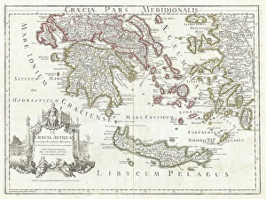
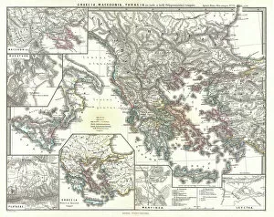
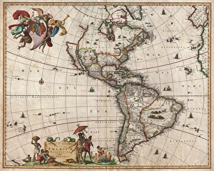
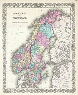
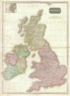
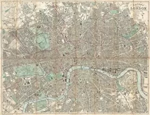
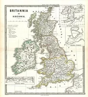
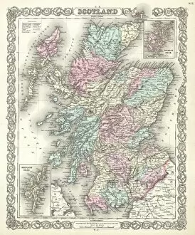
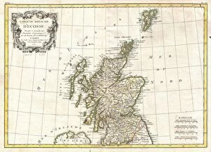
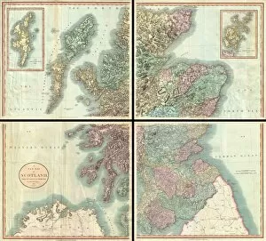
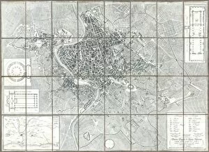
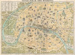
"Exploring the World Through Old Antique Maps: A Glimpse into History and Geography" Step back in time with these captivating old antique maps that offer a fascinating glimpse into the past. One such map is the 1768 James Craig Map of New Town, Edinburgh, Scotland, which showcases the First Plan of New Town and provides valuable insights into its topography. Travel further back to 1794 with the Delisle Map of Southern Ancient Greece, Greek Isles, and Crete. This exquisite piece not only displays intricate topography but also offers a unique perspective on this ancient region's geography. For astronomy enthusiasts, the 1886 Telescopic View and Map of the Moon will surely captivate your imagination. With detailed land features meticulously depicted through cartography and topographical elements, this map takes you on an extraordinary journey beyond Earth's boundaries. Take a leap across continents to explore North America and South America through Visscher's 1658 Map. Discover how early cartographers portrayed their understanding of these vast lands' topography while unraveling their geographical mysteries. The Colton Map of Scandinavia from 1855 invites you to delve into Norway, Sweden, Finland's enchanting landscapes. Immerse yourself in its rich cartographic details as you navigate through fjords and forests. Uncover ancient history with Spruner's 1865 Map of Greece, Macedonia, and Thrace before the Peloponnesian War. This remarkable depiction reveals historical borders alongside intricate topographical features that shaped civilizations long ago. Embark on a journey within London itself using Crutchley Pocket Map or Plan from 1848. As you trace streets and landmarks on this intricately designed map showcasing London's topography at that time period; immerse yourself in England’s vibrant capital city. Discover John Pinkerton’s influential work with his renowned Pinkerton Map of British Isles from1818 - offering an insightful portrayal of England, Scotland, and Ireland's geography.