Fraud Blocker Skip to main content

Paper Collection

"Unfolding History

Background imagePaper Collection: Jubilee Procession in a Cornish Village, A. G. Sherwood Hunter (1846-1919)

Jubilee Procession in a Cornish Village, A. G. Sherwood Hunter (1846-1919)
Oil on canvas, Newlyn School, June 1897. This painting is a wonderful record of a lantern procession held to commemorate Queen Victorias Diamond Jubilee in 1897

Background imagePaper Collection: Map of Ireland 1897

Map of Ireland 1897
Map of Ireland

Background imagePaper Collection: Skull anatomy by Leonardo da Vinci

Skull anatomy by Leonardo da Vinci. Historical artwork and notes on the anatomy of the human skull and teeth, by the Italian artist and scientist Leonardo da Vinci (1452-1519)

Background imagePaper Collection: Old Caucasus map

Old Caucasus map
Antique map of Caucasus

Background imagePaper Collection: Scotland map 1875

Scotland map 1875
The Independent Course Comprehensive Geography by James Monteith, A.S. Barnes & Co, New York & Chicago 1875

Background imagePaper Collection: The Tube Station, c. 1932 (linocut printed in colours on tissue Japan)

The Tube Station, c. 1932 (linocut printed in colours on tissue Japan)
659543 The Tube Station, c.1932 (linocut printed in colours on tissue Japan) by Power, Cyril Edward (1874-1951); 25.5x29 cm; Private Collection; (add.info.: The Tube Station)

Background imagePaper Collection: Copy of The Declaration of Independence in Free Quarker Meeting House

Copy of The Declaration of Independence in Free Quarker Meeting House, Independence National Historical Park, Philadelphia, Pennsylvania, United States of America, North America

Background imagePaper Collection: Map of New York city 1896

Map of New York city 1896
Ilustration of a Map of New York city 1896

Background imagePaper Collection: Map of Maine USA 1883

Map of Maine USA 1883
Warrens Common School Geography

Background imagePaper Collection: Map of the world 1800

Map of the world 1800

Background imagePaper Collection: World map from 1520

World map from 1520
Western hemisphere of the Johannes SchAoner globe from 1520. expedition

Background imagePaper Collection: Peru map 1897

Peru map 1897
The World-Wide Atlas of Modern Geography, Political and Physical W. & A.K. Johnston - London 1897

Background imagePaper Collection: Map of Texas 1867

Map of Texas 1867
Mitchells Modern Atlas - Published by E.H. Buttler & Co - Philadelphia 1867

Background imagePaper Collection: Map of the world 1869

Map of the world 1869
Cornells Grammars-School Geography - S.S. Cornell - New York D. Appleton and Company 1869

Background imagePaper Collection: Map of Australia and New Zealand 1856

Map of Australia and New Zealand 1856
Colton and Fitchs Modern School Geography by George W. Fitch - New York 1856

Background imagePaper Collection: Map of Panama 1864

Map of Panama 1864
Map of Panama - combined with 2 different texture overlays

Background imagePaper Collection: England and Wales map 1875

England and Wales map 1875
The Independent Course Comprehensive Geography by James Monteith, A.S. Barnes & Co, New York & Chicago 1875

Background imagePaper Collection: Italy map 1875

Italy map 1875
The Independent Course Comprehensive Geography by James Monteith, A.S. Barnes & Co, New York & Chicago 1875

Background imagePaper Collection: Palestine map 1875

Palestine map 1875
The Independent Course Comprehensive Geography by James Monteith, A.S. Barnes & Co, New York & Chicago 1875

Background imagePaper Collection: Budapest city map 1895

Budapest city map 1895
Meyers Konversations-Lexikon. Ein Nachschlagewerk des allgemeinen Wissens, 5th edition 17 volumes Bibliographisches Institut - Leipzig 1895-1897

Background imagePaper Collection: Map of the world according to Strabo

Map of the world according to Strabo 63 B.C

Background imagePaper Collection: United States South West Central map 1897

United States South West Central map 1897
The World-Wide Atlas of Modern Geography, Political and Physical W. & A.K. Johnston - London 1897

Background imagePaper Collection: 17th century city, plan of Augsburg, Germany

17th century city, plan of Augsburg, Germany
Typical fortifications and references. Rich in details, beautifully aged paperPublished by J. Stockdale, Piccadilly 1800

Background imagePaper Collection: Holland map 1881

Holland map 1881
Encyclopedia Britannica 9th Edition Vol XII Philadelphia j.M. Stoddart & Co 1881

Background imagePaper Collection: Huntingdon and Cambridge map 1881

Huntingdon and Cambridge map 1881
Encyclopedia Britannica 9th Edition Vol XII Philadelphia j.M. Stoddart & Co 1881

Background imagePaper Collection: Antique map of Russia

Antique map of Russia

Background imagePaper Collection: Mass in B minor (BWV 232), Autograph score by Johann Sebastian Bach (1685-1750)

Mass in B minor (BWV 232), Autograph score by Johann Sebastian Bach (1685-1750)
Johann Sebastian Bach (1685-1750), Mass in B minor (BWV 232). Autograph score

Background imagePaper Collection: French revolutionary politician Jean-Paul Marat, fatally stabbed in his bath by Charlotte Corday

French revolutionary politician Jean-Paul Marat, fatally stabbed in his bath by Charlotte Corday, 13 July 1793
DAVID: THE DEATH OF MARAT. French revolutionary politician Jean-Paul Marat, fatally stabbed in his bath by Charlotte Corday, 13 July 1793. Oil on canvas, 1793, by Jacques Louis David

Background imagePaper Collection: GIRLS FASHIONS, 1952. Page from the September 1952 issue of McCalls magazine

GIRLS FASHIONS, 1952. Page from the September 1952 issue of McCalls magazine, featuring the character Betsy McCall, a paper doll whose cut-out dresses were based on actual fashions manufactured by

Background imagePaper Collection: Punch cartoon: A Warning - Wagners Ring Cycle (engraving)

Punch cartoon: A Warning - Wagners Ring Cycle (engraving)
6034909 Punch cartoon: A Warning - Wagners Ring Cycle (engraving) by English School, (19th century); Private Collection; (add.info.: Punch cartoon: A Warning - Wagners Ring Cycle)

Background imagePaper Collection: Inns of Court 17th century copperplate armorials

Inns of Court 17th century copperplate armorials
This image is from a copperplate engraving, and shows part of a roll of arms from Richard Blome s

Background imagePaper Collection: Map of Kentucky and Tennessee 1855

Map of Kentucky and Tennessee 1855
System of Geography for the use of schools by Sidney E. Morse - Published by Harper & Brothers - New York 1855

Background imagePaper Collection: Map of Texas 1856

Map of Texas 1856
Colton and Fitchs Modern School Geography by George W. Fitch - New York 1856

Background imagePaper Collection: Ireland map 1875

Ireland map 1875
The Independent Course Comprehensive Geography by James Monteith, A.S. Barnes & Co, New York & Chicago 1875

Background imagePaper Collection: Iceland map 1881

Iceland map 1881
Encyclopedia Britannica 9th Edition Vol XII Philadelphia j.M. Stoddart & Co 1881

Background imagePaper Collection: USA indian territories map 1881

USA indian territories map 1881
Encyclopedia Britannica 9th Edition Vol XII Philadelphia j.M. Stoddart & Co 1881

Background imagePaper Collection: Illustration, rolled paper scroll tied with gold ribbon

Illustration, rolled paper scroll tied with gold ribbon

Background imagePaper Collection: British passport

British passport

Background imagePaper Collection: French fries

French fries in a paper cone. These fried, chipped potatoes are high in fat. A diet with too much fatty food is associated with health risks, including an increased risk of heart disease and strokes

Background imagePaper Collection: SOCCER MATCH, 1977. Kevin Keegan of England is tackled by an Argeninian defender during a soccer

SOCCER MATCH, 1977. Kevin Keegan of England is tackled by an Argeninian defender during a soccer match in Buenos Aires, 12 June 1977

Background imagePaper Collection: The Launch

The Launch
Artist: Hart, James Turpin - Title: The Launch - Date: 1858 - Original Medium and Size: Oil on Canvas 35.6 x 45.7

Background imagePaper Collection: Punch cartoon: Faraday Giving His Card to Father Thames (engraving)

Punch cartoon: Faraday Giving His Card to Father Thames (engraving)
6034701 Punch cartoon: Faraday Giving His Card to Father Thames (engraving) by English School, (19th century); Private Collection; (add.info.: Punch cartoon: Faraday Giving His Card to Father Thames)

Background imagePaper Collection: Aquarium Chromolithograph 1895

Aquarium Chromolithograph 1895
Meyers Konversations-Lexikon. Ein Nachschlagewerk des allgemeinen Wissens, 5th edition 17 volumes Bibliographisches Institut - Leipzig 1895-1897

Background imagePaper Collection: Omikuji fortune-telling papers, Tokyo, Japan, Asia

Omikuji fortune-telling papers, Tokyo, Japan, Asia

Background imagePaper Collection: DOG. Schnauzer puppies sitting in paper shreddings

DOG. Schnauzer puppies sitting in paper shreddings
JD-20977 DOG. Schnauzer puppies sitting in paper shreddings John Daniels Please note that prints are for personal display purposes only and may not be reproduced in anyway

Background imagePaper Collection: Plan of the old city Alexandria 1895

Plan of the old city Alexandria 1895
Meyers Konversations-Lexikon. Ein Nachschlagewerk des allgemeinen Wissens, 5th edition 17 volumes Bibliographisches Institut - Leipzig 1895-1897

Background imagePaper Collection: RICHARD WAGNER (1813-1883). German composer. Photographed c1868 at his villa, Triebschen

RICHARD WAGNER (1813-1883). German composer. Photographed c1868 at his villa, Triebschen, near Lucerne, Switzerland

Background imagePaper Collection: Plant sex system by Linnaeus, 1807

Plant sex system by Linnaeus, 1807
Plant sex system by Linnaeus. This diagram, laying out the sexual classification of plants devised by the Swedish botanist Carl Linnaeus (1707-1778)


All Professionally Made to Order for Quick Shipping

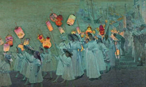
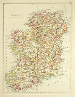
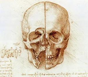
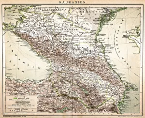
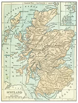
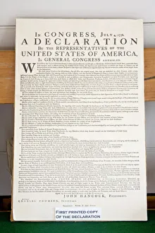
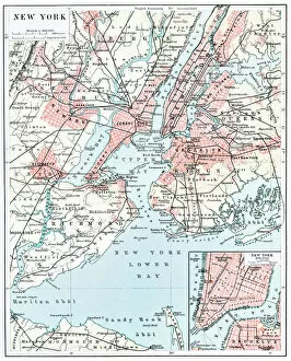
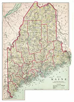
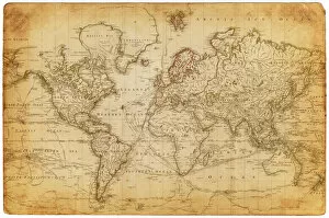
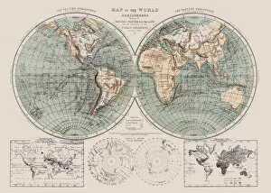
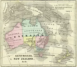
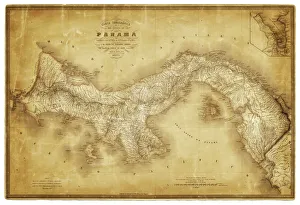
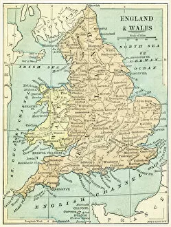
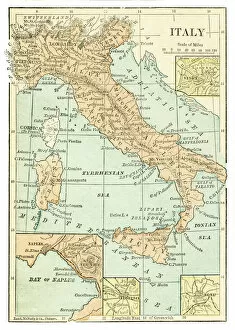
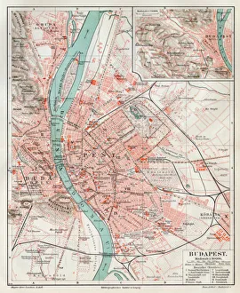
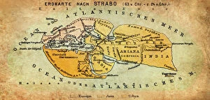
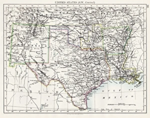
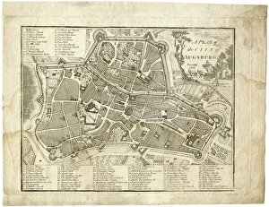
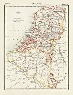
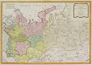
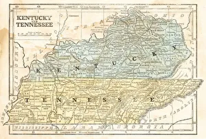
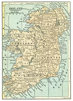
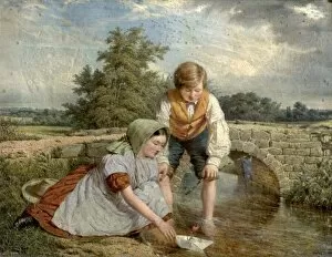
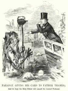
"Unfolding History: Paper as a Timeless Medium" From capturing the grandeur of a Jubilee Procession in a Cornish Village to dissecting the intricacies of skull anatomy by Leonardo da Vinci, it has been an indispensable tool for preserving our past. It holds within its delicate fibers the stories of nations and civilizations. Travel back to 1897 with a Map of Ireland, tracing ancient boundaries and forgotten landscapes. Explore Palestine's rich history through a map from 1875, revealing tales etched into every contour. And behold The Declaration of Independence, carefully preserved in Philadelphia's Free Quaker Meeting House, where ink meets parchment to immortalize freedom's birth. Yet paper is not just for serious matters; it also carries whimsy and satire. In an engraving from Punch magazine, witness Faraday Giving His Card to Father Thames—a comical encounter bridging science and nature. Or chuckle at A Warning - Wagners Ring Cycle cartoon that pokes fun at Wagnerian opera enthusiasts. Paper maps transport us across time and space—whether it be the Map of the World from 1800 unveiling uncharted territories or England and Wales' detailed cartography circa 1875 guiding explorers through familiar lands. Journey through Budapest's streets via a city map from 1895 or navigate New York City's bustling avenues using one from 1896. Even Maine USA reveals its secrets on an intricate map dating back to 1883. In this digital age, let us not forget the humble yet profound power held within each sheet of paper—the ability to connect generations by preserving their triumphs, discoveries, humor, and dreams upon its surface. So next time you hold this seemingly ordinary material in your hands, remember that it is more than just pulp—it is our shared heritage encapsulated within fragile fibers—a testament to human ingenuity throughout centuries gone by.