Fraud Blocker Skip to main content

Population Collection

"Exploring the Diversity

Background imagePopulation Collection: British Isles Counties, Districts and Unitary Authorities Map

British Isles Counties, Districts and Unitary Authorities Map
A political map of the UK and Ireland showing all County, District and Unitary Authority boundaries. Each County is clearly divided into its local District Council areas

Background imagePopulation Collection: Childrens Political British Isles Map

Childrens Political British Isles Map
The British Isles Political map designed for school children was created using Universal Transverse Mercator projection. This political student map clearly marks the counties

Background imagePopulation Collection: British Empire world map, 19th century

British Empire world map, 19th century
British Empire world map. This world map shows the 19th-century British Empire (pink) and its indigenous peoples. Five illustrations (clockwise from upper left) show the people of Australia

Background imagePopulation Collection: Europe at night, satellite image

Europe at night, satellite image. City lights (yellow) of increasing intensity show areas of increasing population, with areas of few lights being more sparsely populated

Background imagePopulation Collection: Whole Earth at night, satellite image

Whole Earth at night, satellite image
Whole Earth map at night, satellite image. Here, Africa is seen at centre. City lights (yellow) of increasing intensity show areas of increasing population

Background imagePopulation Collection: A Fish Pontoon at Grimsby by Fortunio Matania

A Fish Pontoon at Grimsby by Fortunio Matania
An illustration of what was described in the Sphere as one of the greatest fishing ports in the world. In 1790 the population was less than 1, 000 and in 1907 it was 65, 000

Background imagePopulation Collection: Europe at night, satellite image

Europe at night, satellite image. City lights (yellow) show areas of dense population. There are few lights in North Africa (bottom) and the Arctic (top) since they are more sparsely populated

Background imagePopulation Collection: North America at night, satellite image

North America at night, satellite image
Africa at night. Satellite image of the Earth at night, set against a background of stars, centred on the continent of Africa. North is at top. City lights (yellow) show areas of dense population

Background imagePopulation Collection: The Main Street of Dove Holes, Derbyshire, 1913

The Main Street of Dove Holes, Derbyshire, 1913
Photograph of the main street of Dove Holes, near Buxton in Derbyshire, pictured in 1913. Between 1905 and 1913 a quarter of the village population, about 250 people, emigrated to Canada

Background imagePopulation Collection: How Navajo Indian Rugs are made - USA

How Navajo Indian Rugs are made - USA Date: circa 1930s

Background imagePopulation Collection: Maori Chieftain, New Zealand

Maori Chieftain, New Zealand. Date: circa 1910s

Background imagePopulation Collection: Young Uyghur Girl - Kashgar, Xinjiang

Young Uyghur Girl - Kashgar, Xinjiang
Young indigenous Uyghur girl of Kashgar. Photograph by Ralph Ponsonby Watts

Background imagePopulation Collection: South America at night, satellite image

South America at night, satellite image
South America at night. Satellite image of the Earth at night, set against a background of stars, centred on the continent of South America. North is at top

Background imagePopulation Collection: South America at night, satellite image

South America at night, satellite image. City lights (yellow) show areas of dense population, particularly in North America (top left) and South Americas coasts

Background imagePopulation Collection: North America at night, satellite image

North America at night, satellite image. City lights (yellow) show areas of dense population, particularly in North America (upper centre)

Background imagePopulation Collection: Silesia Plebiscite

Silesia Plebiscite
In Silesia, with a mixed German and Polish population, residents of Kattowitz/ Katowice await the results of the plebiscite which will divide the region

Background imagePopulation Collection: MALTHUS (1766 - 1834)

MALTHUS (1766 - 1834)
THOMAS ROBERT MALTHUS philosopher, known for study of population

Background imagePopulation Collection: Picture No. 11981741

Picture No. 11981741
Otter, Road sign warning of otter crossing causeway Benbecula, Outer Hebrides Date:

Background imagePopulation Collection: Babies in a cabbage patch

Babies in a cabbage patch. Date: circa 1900s

Background imagePopulation Collection: Composition of the foreign-born population of the United States by country of birth, 1850-1940

Composition of the foreign-born population of the United States by country of birth, 1850-1940
IMMIGRATION CHART, 1850-1940. Composition of the foreign-born population of the United States by country of birth, 1850-1940

Background imagePopulation Collection: Arecibo message and decoded key C016 / 6817

Arecibo message and decoded key C016 / 6817
Arecibo message and decoded key. Diagram showing the binary transmission (left) known as the Arecibo message, with the message decoded and labelled at centre and right

Background imagePopulation Collection: Playing the Rabana drum - Sinhalese - Colombo, Sri Lanka

Playing the Rabana drum - Sinhalese - Colombo, Sri Lanka
Playing the Rabana drum - Sinhalese people - Colombo, Sri Lanka. The Maha (big) Rabana or Banku (bench) Rabana, played by two or more people at a time is used at wedding festivals

Background imagePopulation Collection: Princess Baa of the Ashanti and her husband - Ghana

Princess Baa of the Ashanti and her husband - Ghana
Princess Baa of the Ashanti and her husband from Ghana - pictured outside the Gold Coast Pavillion at the British Empire Exhibition at Wembley Park in 1924

Background imagePopulation Collection: Bomb damage. The scene in a street in East Ham, East London, typical of so many

Bomb damage. The scene in a street in East Ham, East London, typical of so many after an air raid

Background imagePopulation Collection: Americas, South America, Ecuador, Quito. At over 9, 000 feet in elevation, the capitol of Ecuador

Americas, South America, Ecuador, Quito. At over 9, 000 feet in elevation, the capitol of Ecuador
Ecuador, Quito. At over 9, 000 feet in elevation Quito sits in a valley surrounded by the Andes mountains, providing countless scenic vistas. Quito was the first established UNESCO World Heritage site

Background imagePopulation Collection: Southeast Asia at night, satellite image

Southeast Asia at night, satellite image
Southeast Asia at night. Satellite image of the Earth seen at 18:00 (6pm) GMT (UCT), centred on China. City lights (yellow) show areas of dense population, particularly in India (left)

Background imagePopulation Collection: The new coffee tavern at Bradford

The new coffee tavern at Bradford
Interior and exterior views of the new coffee tavern in Bradford, inaugurated by W. E Forster, M.P in 1879. The Coffee Tavern movement was a Victorian effort to get people out of pubs

Background imagePopulation Collection: Italy at night, ISS image

Italy at night, ISS image
Italy at night. International Space Station (ISS) image of Italy (centre) and the Adriatic coast (right) at night. The island of Sicily is at centre left

Background imagePopulation Collection: Africa, night-day satellite image

Africa, night-day satellite image. This composite image of the Earth is set against a background of stars, and is centred on the continent of Africa. North is at top

Background imagePopulation Collection: Whole Earth at night, satellite image

Whole Earth at night, satellite image. This map is centred on the Greenwich meridian, at zero degrees latitude. City lights (yellow) show areas of dense population

Background imagePopulation Collection: West Africa - Nigeria - Kano - Sanusi People

West Africa - Nigeria - Kano - Sanusi People. Date: circa late 1950s

Background imagePopulation Collection: GALICIA. SANTIAGO DE COMPOSTELA. Province of A Coruna

GALICIA. SANTIAGO DE COMPOSTELA. Province of A Coruna
Galicia. Santiago de Compostela. Province of Coruna. Partial view of the city with the Cathedral in the background. The Spanish and American Illustration. Engraving by Otero (1870)

Background imagePopulation Collection: Chinook Basket Maker - British Columbia, Canada

Chinook Basket Maker - British Columbia, Canada. The use of the word Kloochman on this postcard is an example of chinook jargon, meaning Wife. Date: circa 1910s

Background imagePopulation Collection: Bibi Ka Magbara, Indias mini Taj Mahal at Aurangabad in Southwest India

Bibi Ka Magbara, Indias mini Taj Mahal at Aurangabad in Southwest India

Background imagePopulation Collection: Wild West covered wagons

Wild West covered wagons. Simulated old photograph of covered wagons on the Oregon trail. Covered wagons, or Prairie schooners, are icons of the American Old West

Background imagePopulation Collection: French poster of the occupation

French poster of the occupation
Populations abandonnees, faites confiance au soldat allemand! World War Two propaganda poster of occupied France encouraging the abandoned population to have confidence in German soldiers

Background imagePopulation Collection: Papua New Guinea - Elevara Mission and L. M.s Mission

Papua New Guinea - Elevara Mission and L. M.s Mission
Papua New Guinea - Elevara Village and the L.M.S. Mission. The London Missionary Society was a non-denominational missionary society formed in England in 1795 by evangelical Anglicans

Background imagePopulation Collection: Australia at night, satellite image

Australia at night, satellite image. City lights (yellow) show areas of more dense population, particularly in Southeast Asia (top left) and on Australias east coast

Background imagePopulation Collection: Census 1891

Census 1891
Census Registrars district 31. Sub-districts 1, 2 and 3, Walton, Chertsey, Chobham, 1891 Date: 1891

Background imagePopulation Collection: Food being unloaded in the Channel Islands; Second World War

Food being unloaded in the Channel Islands; Second World War
Photograph showing the unloading of crates of food in St. Peter Port, Guernsey, 1945. After nearly five years of German occupation the civilian population of the islands had very little food

Background imagePopulation Collection: Sir James Brooke / Census

Sir James Brooke / Census
SIR JAMES BROOKE Governor of Labuan, later Rajah of Sarawak, at a time when the overseas population of the British Empire numbered 139 million

Background imagePopulation Collection: Russia - Yakutsk

Russia - Yakutsk
Town in eastern Russia, on the Lena river. Today it has a population of 200000 and a university. The Stolbi rocks are as impressive as ever

Background imagePopulation Collection: Synagogue at Stockholm

Synagogue at Stockholm
The synagogue for Stockholms Jewish population. Date: 1881

Background imagePopulation Collection: 'Populations de l'Afrique australe; Afrique Australe, 1914. Creator: Unknown

'Populations de l'Afrique australe; Afrique Australe, 1914. Creator: Unknown
'Populations de l'Afrique australe; Afrique Australe, 1914. From "Grande Geographie Bong Illustree", 1914

Background imagePopulation Collection: Colored population ratio to total population 1880, 1897. Creator: Unknown

Colored population ratio to total population 1880, 1897. Creator: Unknown
Colored population ratio to total population 1880, 1897

Background imagePopulation Collection: The Graphic Statistical Maps of Ireland; Religion 1881, 1886. Creator: Unknown

The Graphic Statistical Maps of Ireland; Religion 1881, 1886. Creator: Unknown
The Graphic Statistical Maps of Ireland; Religion 1881, 1886. From "The Graphic. An Illustrated Weekly Newspaper Volume 33. January to June, 1886"

Background imagePopulation Collection: The Graphic Statistical Maps of Ireland; Education 1881, 1886. Creator: Unknown

The Graphic Statistical Maps of Ireland; Education 1881, 1886. Creator: Unknown
The Graphic Statistical Maps of Ireland; Education 1881, 1886. From "The Graphic. An Illustrated Weekly Newspaper Volume 33. January to June, 1886"

Background imagePopulation Collection: The Graphic Statistical Maps of Ireland; Population 1881, 1886. Creator: Unknown

The Graphic Statistical Maps of Ireland; Population 1881, 1886. Creator: Unknown
The Graphic Statistical Maps of Ireland; Population 1881, 1886. From "The Graphic. An Illustrated Weekly Newspaper Volume 33. January to June, 1886"


All Professionally Made to Order for Quick Shipping

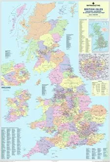
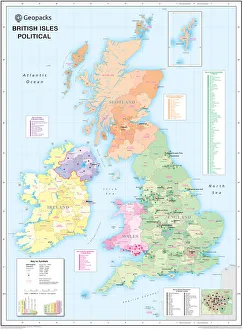
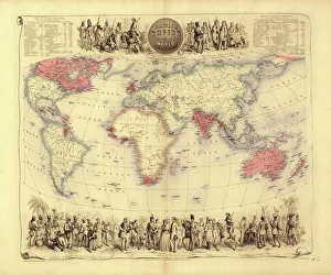
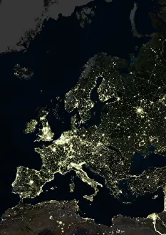
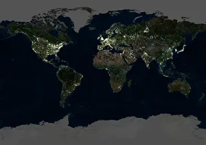
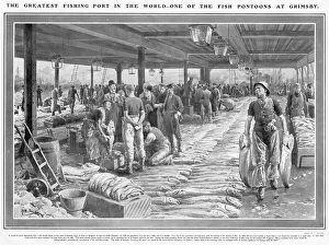
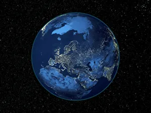
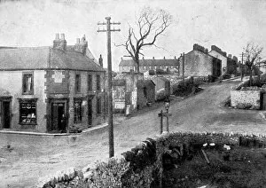
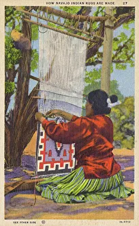
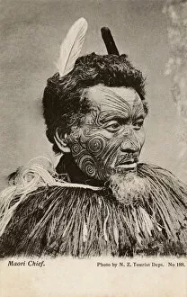
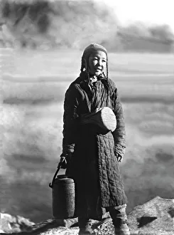
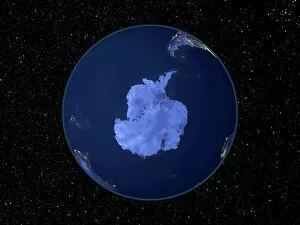
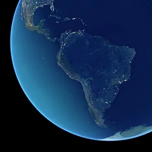
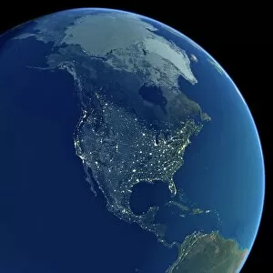
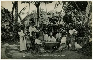
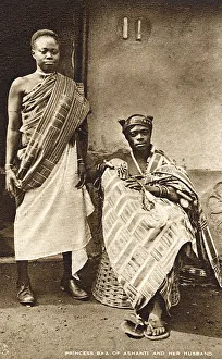
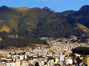
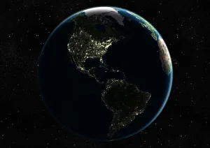
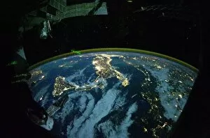
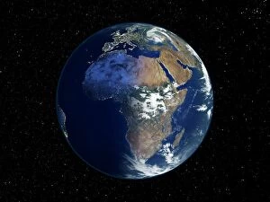
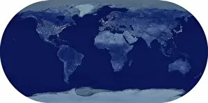
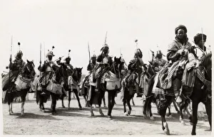
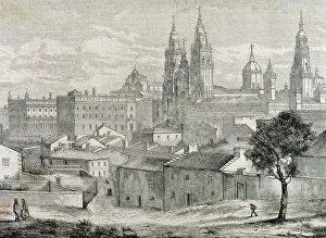
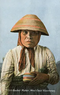
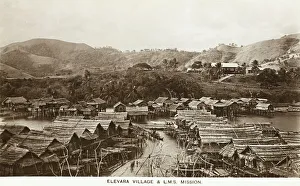
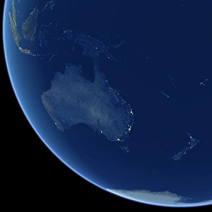
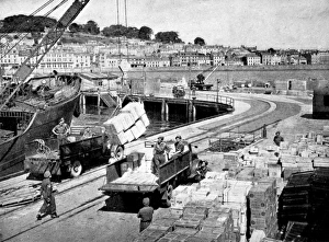
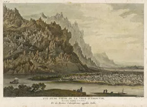
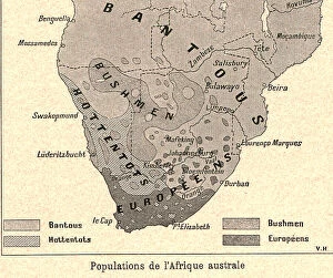
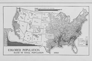
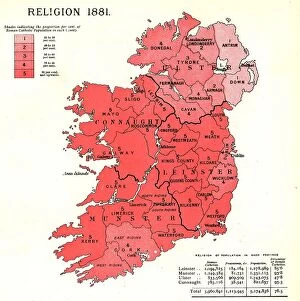
"Exploring the Diversity: From British Isles to Global Perspectives on Population" Discover the intricate tapestry distribution across the British Isles with our detailed map of Counties, Districts, and Unitary Authorities. Ignite curiosity in young minds with a Children's Political British Isles Map, showcasing how population shapes political boundaries. Step back in time with a 19th-century British Empire world map and witness the vast territories influenced by its population dynamics. Witness Europe come alive at night through a captivating satellite image, revealing bustling cities and vibrant communities. Marvel at the breathtaking beauty of our planet as you explore a satellite image capturing the Whole Earth at night - an awe-inspiring testament to global population centers. Embark on a nocturnal journey across North America through an enchanting satellite image that illuminates its diverse populations after sunset. Meet an adorable Young Uyghur Girl from Kashgar, Xinjiang, offering glimpses into unique cultures shaped by their local populations. Gain perspective on European urbanization patterns as you observe another striking satellite image showcasing Europe at night - where lights tell stories of human settlement and activity. Travel back in time to 1913 Dove Holes, Derbyshire, and stroll along its Main Street teeming with life - a snapshot of local population dynamics from over a century ago. Immerse yourself in Fortunio Matania's artwork depicting Grimsby's Fish Pontoon - witness how fishing communities thrive thanks to their reliance on abundant marine resources driven by local populations' needs. Uncover the fascinating process behind Navajo Indian Rugs' creation in the USA - these masterpieces reflect generations of cultural heritage intertwined with indigenous populations' resilience and creativity. Explore Maori culture through an intriguing portrait of a Maori Chieftain from New Zealand – discover how this vibrant community's population has shaped their traditions and identity.