Fraud Blocker Skip to main content

Theatre Of War Collection

"Theatre of War

Background imageTheatre Of War Collection: Map of Suvla Bay, Gallipoli peninsula, First World War, 1915, (c1920). Creator: Unknown

Map of Suvla Bay, Gallipoli peninsula, First World War, 1915, (c1920). Creator: Unknown
Map of Suvla Bay, Gallipoli peninsula, First World War, 1915, (c1920). After the Suvla Bay Landing: Approximate Positions of General Stopfords Divisions on the night of August 7, 1915

Background imageTheatre Of War Collection: Map of the North Sea and the Baltic, c1914, (c1920). Creator: John Bartholomew & Son

Map of the North Sea and the Baltic, c1914, (c1920). Creator: John Bartholomew & Son
Map of the North Sea and the Baltic, c1914, (c1920). Northern Europe at the start of the First World War, including parts of Norway, Sweden, Finland, Russia, Germany, Denmark

Background imageTheatre Of War Collection: Battle of the Somme, First World War, July 1916, (c1920). Creator: Unknown

Battle of the Somme, First World War, July 1916, (c1920). Creator: Unknown
Battle of the Somme, First World War, July 1916, (c1920). Map of northern France showing Successive Stages of Advance at the Fricourt Salient...British line in black, Enemy Defences [Germans] in red

Background imageTheatre Of War Collection: Map showing approximately the area gained on the Thiepval Ridge... 1916, (c1920)

Map showing approximately the area gained on the Thiepval Ridge... 1916, (c1920)
Map showing approximately the area gained on the Thiepval Ridge between September 14 and October 31, 1916, (c1920). The British line in northern France during the Battle of the Somme

Background imageTheatre Of War Collection: The Baltic Sea and Its Approaches, First World War, c1915, (c1920)

The Baltic Sea and Its Approaches, First World War, c1915, (c1920). Map of part of northern Europe, showing sections of the coasts of Norway, Sweden, Russia, Germany and Denmark

Background imageTheatre Of War Collection: positions in the Battle of Verdun, northern France, First World War, 1916, (c1920)

positions in the Battle of Verdun, northern France, First World War, 1916, (c1920)
French and German positions in the Battle of Verdun, northern France, First World War, 1916, (c1920). Solid red line indicates French

Background imageTheatre Of War Collection: Map illustrating the Brest-Litovsk Treaties, First World War, c1918, (c1920). Creator: Unknown

Map illustrating the Brest-Litovsk Treaties, First World War, c1918, (c1920). Creator: Unknown
Map illustrating the Brest-Litovsk Treaties, First World War, c1918, (c1920). Pink: Areas taken by Germany ; dark blue: Nationalities of self-determination ; light blue

Background imageTheatre Of War Collection: Map of German South West Africa, First World War, (c1920). Creator: John Bartholomew & Son

Map of German South West Africa, First World War, (c1920). Creator: John Bartholomew & Son
Map of German South West Africa, First World War, (c1920). The German annexation of South West Africa took place in the 1880s

Background imageTheatre Of War Collection: Austria-Hungary and Neighbouring Lands - Map, 1920. Creator: John Bartholomew & Son

Austria-Hungary and Neighbouring Lands - Map, 1920. Creator: John Bartholomew & Son
Austria-Hungary and Neighbouring Lands, c1914, (c1920). Map of the Austro-Hungarian Empire and surrounding countries at start of the First World War

Background imageTheatre Of War Collection: Political Map of Africa, 1914, (1920). Creator: John Bartholomew & Son

Political Map of Africa, 1914, (1920). Creator: John Bartholomew & Son
Political Map of Africa, 1914, (1920). Colonial possessions in Africa at the start of the First World War. British colonies are pink, French - green, German - orange, Portuguese - purple

Background imageTheatre Of War Collection: Map illustrating the Closing Phases of the East African Campaign, 1917-18, (c1920)

Map illustrating the Closing Phases of the East African Campaign, 1917-18, (c1920). European powers in Africa during the First World War

Background imageTheatre Of War Collection: The Conquest of the Cameroons, First World War, 1914-1916, (c1920). Creator: Unknown

The Conquest of the Cameroons, First World War, 1914-1916, (c1920). Creator: Unknown
The Conquest of the Cameroons, First World War, 1914-1916, (c1920)....map showing approximately how the colony was cleared of the German troops

Background imageTheatre Of War Collection: Map illustrating the Operations at Verdun, First World War, August-November, 1917, (c1920)

Map illustrating the Operations at Verdun, First World War, August-November, 1917, (c1920). Map of the area around the town of Verdun in northern France, showing Line from which the French started

Background imageTheatre Of War Collection: Map of Ypres, West Flanders, Belgium, First World War, (c1920). Creator: Unknown

Map of Ypres, West Flanders, Belgium, First World War, (c1920). Creator: Unknown
Map of Ypres, West Flanders, Belgium, First World War, (c1920). The Ypres Salient before the Battle of July 31, 1917: map showing the approximate positions of the Franco-British Line

Background imageTheatre Of War Collection: The Allies Line facing the Bulgarians in the closing Campaign of 1916, (c1920)

The Allies Line facing the Bulgarians in the closing Campaign of 1916, (c1920). Map of Salonika (Thessaloniki) in Greece, showing Allied positions during the First World War: Russian, French

Background imageTheatre Of War Collection: Gorizia and the Carso: map illustrating the Italian advance towards Trieste in 1916, (c1920)

Gorizia and the Carso: map illustrating the Italian advance towards Trieste in 1916, (c1920). Italian lines in northern Italy during the First World War

Background imageTheatre Of War Collection: Map illustrating the Campaigns in Egypt from February, 1915, to May, 1916, . Creator: Unknown

Map illustrating the Campaigns in Egypt from February, 1915, to May, 1916, . Creator: Unknown
Map illustrating the Campaigns in Egypt from February, 1915, to May, 1916, (c1920). Alexandria and the Nile delta, Cairo, Port Said, the Suez Canal and the Sinai Peninsula during the First World War

Background imageTheatre Of War Collection: Colonial possessions in East Africa during the First World War, c1916, (c1920). Creator: Unknown

Colonial possessions in East Africa during the First World War, c1916, (c1920). Creator: Unknown
Colonial possessions in East Africa during the First World War, c1916, (c1920). Map showing German East Africa, British East Africa, the Belgian Congo, Rhodesia, Uganda

Background imageTheatre Of War Collection: Map illustrating the German Retirement after the Battle of the Somme, (c1920). Creator: Unknown

Map illustrating the German Retirement after the Battle of the Somme, (c1920). Creator: Unknown
Map illustrating the German Retirement after the Battle of the Somme, (c1920). The First World War Battle of the Somme, fought between the armies of the British Empire

Background imageTheatre Of War Collection: Allied positions on the Gallipoli peninsula in Turkey, First World War, July 1915, (c1920)

Allied positions on the Gallipoli peninsula in Turkey, First World War, July 1915, (c1920). The Operations in the Southern Area of Gallipoli

Background imageTheatre Of War Collection: Map of the Austro-Italian frontier, First World War, (c1920). Creator: John Bartholomew & Son

Map of the Austro-Italian frontier, First World War, (c1920). Creator: John Bartholomew & Son
Map of the Austro-Italian frontier, First World War, (c1920). Mountainous area between Salzburg, Trieste and Cremona, showing the Tyrol

Background imageTheatre Of War Collection: The Ypres Salient before and after the Second Battle of Ypres... First World War, 1915, (c1920)

The Ypres Salient before and after the Second Battle of Ypres... First World War, 1915, (c1920)
The Ypres Salient before and after the Second Battle of Ypres, April 22-May 13, First World War, 1915, (c1920). Map showing positions of the allied forces around Ypres in Belgium: French

Background imageTheatre Of War Collection: Asia Minor, the Caucasus Region and Mesopotamia, First World War, c1915, (c1920)

Asia Minor, the Caucasus Region and Mesopotamia, First World War, c1915, (c1920). Map of part of the Middle East, showing eastern Turkey, Cyprus, Syria, Lebanon, Palestine

Background imageTheatre Of War Collection: Map of East Africa, First World War, (c1920). Creator: John Bartholomew & Son

Map of East Africa, First World War, (c1920). Creator: John Bartholomew & Son
Map of East Africa, First World War, (c1920). Map showing colonial possessions including the Belgian Congo, British East Africa, German East Africa, Northern Rhodesia and Portuguese East Africa

Background imageTheatre Of War Collection: Map of the Dardanelles, First World War, 1915, (c1920). Creator: Unknown

Map of the Dardanelles, First World War, 1915, (c1920). Creator: Unknown
Map of the Dardanelles, First World War, 1915, (c1920). Bird s-eye View of the Dardanelles from the Entrance to the Straits to the Narrows

Background imageTheatre Of War Collection: Map of the Turkish attack on the Suez Canal, Egypt, First World War, 1915, (c1920)

Map of the Turkish attack on the Suez Canal, Egypt, First World War, 1915, (c1920). Map showing approximately the direction of the Turkish Attack on the Suez Canal, January 25 - February 3, 1915

Background imageTheatre Of War Collection: Map of the border between Russia and Turkey, First World War, (c1920). Creator: Unknown

Map of the border between Russia and Turkey, First World War, (c1920). Creator: Unknown
Map of the border between Russia and Turkey, First World War, (c1920). Map illustrating Turkeys disastrous Advance in the Caucasus and her Invasion of Persia - December, 1914 - January, 1915

Background imageTheatre Of War Collection: Black Sea: Bosphorus and Dardanelles, c1914, (c1920). Creator: John Bartholomew & Son

Black Sea: Bosphorus and Dardanelles, c1914, (c1920). Creator: John Bartholomew & Son
Black Sea: Bosphorus and Dardanelles, c1914, (c1920). Map of the Black Sea and parts of surrounding countries at the start of the First World War, showing Russia and the Crimea, Romania

Background imageTheatre Of War Collection: Map of South Africa, c1914, (c1920). Creator: John Bartholomew & Son

Map of South Africa, c1914, (c1920). Creator: John Bartholomew & Son
Map of South Africa, c1914, (c1920). Map of the southern tip of Africa at the start of the First World War, showing German South-West Africa (later Namibia)

Background imageTheatre Of War Collection: The Balkan States After the Wars of 1912-13, (c1920). Creator: John Bartholomew & Son

The Balkan States After the Wars of 1912-13, (c1920). Creator: John Bartholomew & Son
The Balkan States After the Wars of 1912-13, (c1920). Showing Acquisitions of Territory in Darker Tints. Map of the Balkans: Bosnia, Montenegro, Servia (Serbia), Albania, Roumania (Romania)

Background imageTheatre Of War Collection: Poland and the Partitions of 1772, 1793 & 1795, (c1920). Creator: John Bartholomew & Son

Poland and the Partitions of 1772, 1793 & 1795, (c1920). Creator: John Bartholomew & Son
Poland and the Partitions of 1772, 1793 & 1795, (c1920). Map showing how territory in Europe was divided between the empires of Russia, Prussia and Austria in the 18th century

Background imageTheatre Of War Collection: Map of Central Europe, c1914. Creator: John Bartholomew & Son

Map of Central Europe, c1914. Creator: John Bartholomew & Son
Map of Central Europe, c1914. Europe as it looked at the beginning of the First World War. From " The Great World War - A History" Volume I, edited by Frank A Mumby

Background imageTheatre Of War Collection: Sketch Map of the Valley of the Aisne above Soissons, 1914, (c1920). Creator: Unknown

Sketch Map of the Valley of the Aisne above Soissons, 1914, (c1920). Creator: Unknown
Sketch Map of the Valley of the Aisne above Soissons, 1914, (c1920). Part of northern France, showing Laon and Rheims, at the start of the First World War

Background imageTheatre Of War Collection: The Second Phase of the Great Retreat... 1914, (c1920). Creator: Unknown

The Second Phase of the Great Retreat... 1914, (c1920). Creator: Unknown
The Second Phase of the Great Retreat: Plan Showing the British Positions from August 28 to September 6, 1914, 1920. The map also indicates the positions of the Allies

Background imageTheatre Of War Collection: The First Phase of the Great Retreat... 1914, (c1920). Creator: Unknown

The First Phase of the Great Retreat... 1914, (c1920). Creator: Unknown
The First Phase of the Great Retreat: Plan Showing the British Positions from August 23 to August 28, 1914, (c1920). Map of northern France and Belgium

Background imageTheatre Of War Collection: Map of Belgium and Northern France, c1914, (c1920). Creator: John Bartholomew & Son

Map of Belgium and Northern France, c1914, (c1920). Creator: John Bartholomew & Son
Map of Belgium and Northern France, c1914, (c1920). How the area looked at the start of the First World War. From " The Great World War - A History" Volume I, edited by Frank A Mumby

Background imageTheatre Of War Collection: Map to Illustrate the Mesopotamian Expedition, 1919. Creator: George Philip & Son Ltd

Map to Illustrate the Mesopotamian Expedition, 1919. Creator: George Philip & Son Ltd
Map to Illustrate the Mesopotamian Expedition, 1919. Showing the Middle Eastern theatre of World War I, including the Turkish or Ottoman Empire, and parts of Russia, Persia and Egypt

Background imageTheatre Of War Collection: Geographical Map of the Theatre of War, showing the Kingdom of Hungary in the main

Geographical Map of the Theatre of War, showing the Kingdom of Hungary in the main
986323 Geographical Map of the Theatre of War, showing the Kingdom of Hungary in the main, 1771 (hand-coloured engraving.) by German School

Background imageTheatre Of War Collection: The Russo-Chinese Difficulty, the Theatre of War in Eastern Siberia (litho)

The Russo-Chinese Difficulty, the Theatre of War in Eastern Siberia (litho)
1599978 The Russo-Chinese Difficulty, the Theatre of War in Eastern Siberia (litho) by Frenzeny, Paul (1840-1902); Private Collection; (add.info.: The Russo-Chinese Difficulty)

Background imageTheatre Of War Collection: Sketches at the Brighton Theatre of War (engraving)

Sketches at the Brighton Theatre of War (engraving)
1613951 Sketches at the Brighton Theatre of War (engraving) by English School, (19th century); Private Collection; (add.info.: Sketches at the Brighton Theatre of War)

Background imageTheatre Of War Collection: The Possible Theatre of War in South Africa, showing the Mountain Ranges separating the Transvaal

The Possible Theatre of War in South Africa, showing the Mountain Ranges separating the Transvaal
1593126 The Possible Theatre of War in South Africa, showing the Mountain Ranges separating the Transvaal and the Orange Free State from Natal (litho) by English School

Background imageTheatre Of War Collection: The Theatre of War (engraving)

The Theatre of War (engraving)
668375 The Theatre of War (engraving) by Leech, John (1817-64); Private Collection; (add.info.: The Theatre of War. Illustration for John Leechs Pictures of Life and Character (c 1890)

Background imageTheatre Of War Collection: The Theatre of War, the Epilogue (engraving)

The Theatre of War, the Epilogue (engraving)
1052647 The Theatre of War, the Epilogue (engraving) by Gregory, Edward John (1850-1909); Private Collection; (add.info.: The Theatre of War, the Epilogue)

Background imageTheatre Of War Collection: The Charge, 1918. Creator: George Wesley Bellows

The Charge, 1918. Creator: George Wesley Bellows
The Charge, 1918

Background imageTheatre Of War Collection: Map showing the Canal System connecting Zeebrugge and Ostend with Bruges... (c1920)

Map showing the Canal System connecting Zeebrugge and Ostend with Bruges... (c1920)
Map showing the Canal System connecting Zeebrugge and Ostend with Bruges, First World War, (c1920). The Belgian ports of Ostend and Zeebrugge were connected to the city of Bruges via canals

Background imageTheatre Of War Collection: The Battle of Jutland Bank, May 31-June 1, 1916, (c1920). Creator: Unknown

The Battle of Jutland Bank, May 31-June 1, 1916, (c1920). Creator: Unknown
The Battle of Jutland Bank, May 31-June 1, 1916, (c1920). Map showing the Approximate Positions of the British and German Fleets at Various Stages of the Battle

Background imageTheatre Of War Collection: The Scene of the Battle of Jutland, May 31-June 1, 1916, (c1920). Creator: Unknown

The Scene of the Battle of Jutland, May 31-June 1, 1916, (c1920). Creator: Unknown
The Scene of the Battle of Jutland, May 31-June 1, 1916, (c1920). Map of the North Sea, showing the coastlines of Norway, Denmark, Germany, Holland, Belgium and Great Britain

Background imageTheatre Of War Collection: Map illustrating the First Battles of Cambrai, November-December 1917, (c1920). Creator: Unknown

Map illustrating the First Battles of Cambrai, November-December 1917, (c1920). Creator: Unknown
Map illustrating the First Battles of Cambrai, November-December 1917, (c1920). Note - Hill shading is shown only in the area covered by the sphere of operations described


All Professionally Made to Order for Quick Shipping

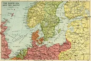
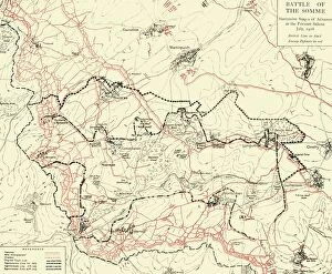
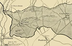
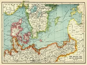
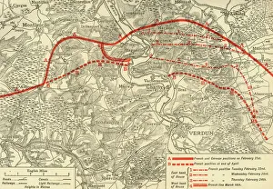
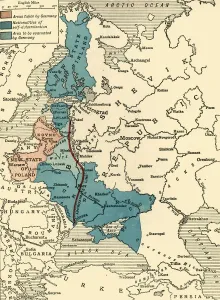
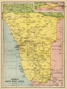
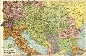
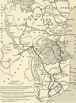
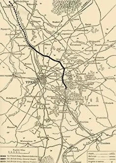
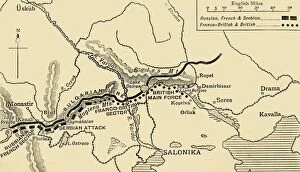
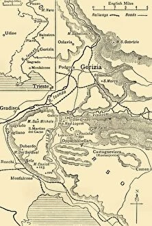
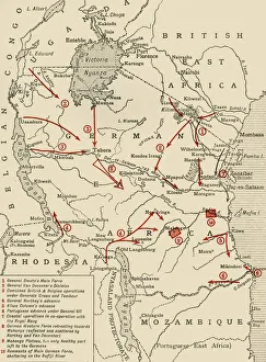
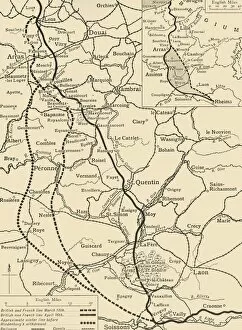
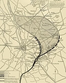
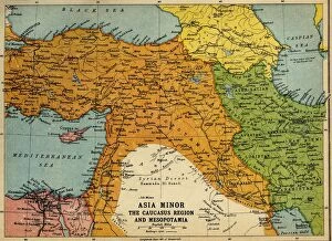
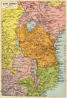
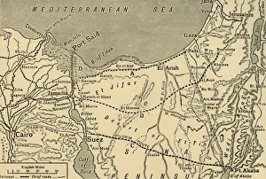
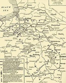
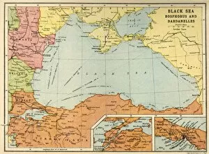
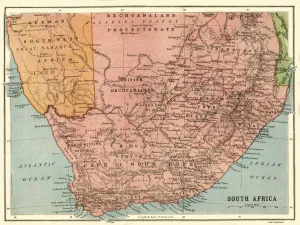
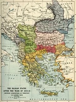
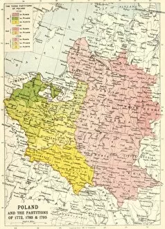
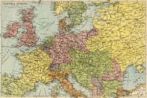
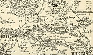
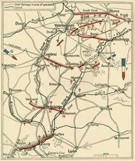
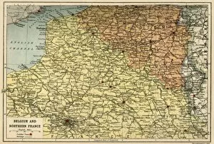
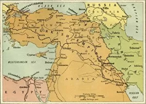
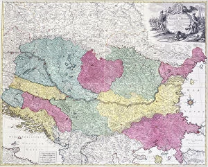
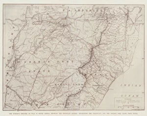
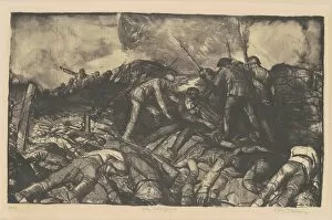
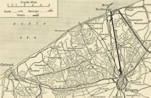
"Theatre of War: A Visual Journey through the Battlegrounds of History" Step into the past and witness the dramatic landscapes that shaped some of history's most significant conflicts. This captivating collection of maps offers a glimpse into the theatre of war, where nations clashed and destinies were decided. Travel back to 1915 with a map showcasing Suvla Bay on the Gallipoli peninsula during the First World War. Feel the tension in the air as troops maneuvered across this strategic battleground, fighting for control amidst treacherous terrain. Next, immerse yourself in July 1916, as you explore a map depicting the Battle of Somme. Experience both awe and horror as you visualize soldiers charging forward against seemingly insurmountable odds, forever etching their names into history. Venture towards naval warfare with a detailed map highlighting positions in the North Sea and Baltic during this tumultuous time. Witness how these vast bodies of water became arenas for intense battleships clashes between rival powers. Shift your focus to France's Thiepval Ridge in 1916, where an illustrated map showcases territorial gains made during one of World War I's bloodiest offensives. Marvel at how every inch gained came at an immense cost, reminding us all of war's devastating toll. Delve deeper into Europe with another set of maps illustrating positions during Verdun - a grueling battle that consumed northern France throughout 1916. These maps serve as haunting reminders that even picturesque landscapes can become theaters for unimaginable horrors. Explore beyond Europe's borders with maps revealing key moments from other global theatres. Discover how political boundaries shifted within Africa before and after World War I – from John Bartholomew & Son’s intricate depictions to closing phases in East African campaigns or conquests like The Cameroons. Finally, journey to German South West Africa (now Namibia) or Austria-Hungary and its neighboring lands.