Fraud Blocker Skip to main content

Tropic Of Cancer Collection

"Exploring the Tropic of Cancer: A Journey through Discoveries, Slavery

Background imageTropic Of Cancer Collection: Map of Africa showing its most recent discoveries with the Island of St

Map of Africa showing its most recent discoveries with the Island of St
XOS1765717 Map of Africa showing its most recent discoveries with the Island of St. Helena inset from Mitchells new general atlas, 1863 (colour engraving) by American School

Background imageTropic Of Cancer Collection: Map and diagram of the world, folio a4v of Orbis Breviarium by Zaccaria Lilio (d. c)

Map and diagram of the world, folio a4v of Orbis Breviarium by Zaccaria Lilio (d. c)
488665 Map and diagram of the world, folio a4v of Orbis Breviarium by Zaccaria Lilio (d.c.1522), Florence, 1493 (print & woodcut) by Italian School

Background imageTropic Of Cancer Collection: Winter Solstice, Plate 5 from Globi coelestis in tabulas planas redacti descriptio, pub

Winter Solstice, Plate 5 from Globi coelestis in tabulas planas redacti descriptio, pub
3075759 Winter Solstice, Plate 5 from Globi coelestis in tabulas planas redacti descriptio, pub. 1674 (hand coloured engraving) by Pardies

Background imageTropic Of Cancer Collection: Zone (engraving)

Zone (engraving)
3653691 Zone (engraving) by English School, (19th century); Private Collection; (add.info.: Zone. Illustration for The Imperial Dictionary by John Ogilvie)

Background imageTropic Of Cancer Collection: Planisphaerii Coelestis Hemisphaerium Septentrionale, from Atlas Coelestis, pub

Planisphaerii Coelestis Hemisphaerium Septentrionale, from Atlas Coelestis, pub
3075762 Planisphaerii Coelestis Hemisphaerium Septentrionale, from Atlas Coelestis, pub. 1706 (hand coloured engraving) by Allard

Background imageTropic Of Cancer Collection: Navigation chart showing China, Ceylon and the Philippines and the Tropics of Cancer

Navigation chart showing China, Ceylon and the Philippines and the Tropics of Cancer and Capricorn, c. 1540 (vellum)
3854274 Navigation chart showing China, Ceylon and the Philippines and the Tropics of Cancer and Capricorn, c.1540 (vellum) by Agnese, Battista (1514-64); Photo © Derek Bayes

Background imageTropic Of Cancer Collection: Vernal Equinox, Plate 2 from Globi coelestis in tabulas planas redacti descriptio, pub

Vernal Equinox, Plate 2 from Globi coelestis in tabulas planas redacti descriptio, pub
3075758 Vernal Equinox, Plate 2 from Globi coelestis in tabulas planas redacti descriptio, pub. 1674 (hand coloured engraving) by Pardies

Background imageTropic Of Cancer Collection: Vue du pronaos du Temple de Dandour (Tropique du Cancer), April 7, 1850

Vue du pronaos du Temple de Dandour (Tropique du Cancer), April 7, 1850

Background imageTropic Of Cancer Collection: Propylon du Temple de Dandour (Tropique du Cancer), April 1850. Creator: Maxime du Camp

Propylon du Temple de Dandour (Tropique du Cancer), April 1850. Creator: Maxime du Camp
Propylon du Temple de Dandour (Tropique du Cancer), April 1850

Background imageTropic Of Cancer Collection: Vue prise au Village d Abou-hor (Tropique du Cancer), April 1850. Creator: Maxime du Camp

Vue prise au Village d Abou-hor (Tropique du Cancer), April 1850. Creator: Maxime du Camp
Vue prise au Village d Abou-hor (Tropique du Cancer), April 1850

Background imageTropic Of Cancer Collection: Vue du Village d Abou-hor (Tropique du Cancer), April 1850. Creator: Maxime du Camp

Vue du Village d Abou-hor (Tropique du Cancer), April 1850. Creator: Maxime du Camp
Vue du Village d Abou-hor (Tropique du Cancer), April 1850

Background imageTropic Of Cancer Collection: Planisphaerii Coelestis Hemisphaerium Septentrionale, 1706

Planisphaerii Coelestis Hemisphaerium Septentrionale, 1706
Planisphaerii Coelestis Hemisphaerium Septentrionale, from Atlas Coelestis, pub. 1706 (hand coloured engraving)

Background imageTropic Of Cancer Collection: Winter Solstice, Plate 5 from Globi coelestis in tabulas planas redacti descriptio, 1674

Winter Solstice, Plate 5 from Globi coelestis in tabulas planas redacti descriptio, 1674
Winter Solstice, Plate 5 from Globi coelestis in tabulas planas redacti descriptio, Ignace-Gaston Pardies, pub. 1674 (hand coloured engraving)

Background imageTropic Of Cancer Collection: Vernal Equinox, Plate 2 from Globi coelestis in tabulas planas redacti descriptio, 1674

Vernal Equinox, Plate 2 from Globi coelestis in tabulas planas redacti descriptio, 1674
Vernal Equinox, Plate 2 from Globi coelestis in tabulas planas redacti descriptio, Ignace-Gaston Pardies, pub. 1674 (hand coloured engraving)

Background imageTropic Of Cancer Collection: Illustration of suns rays reaching the Earth, creating the greatest heat in the tropics

Illustration of suns rays reaching the Earth, creating the greatest heat in the tropics and impinging at oblique angle towards the poles (solar heating)

Background imageTropic Of Cancer Collection: The Continent of Africa, from an Atlas of the World in 33 Maps, Venice, 1st September 1553

The Continent of Africa, from an Atlas of the World in 33 Maps, Venice, 1st September 1553
XOT330946 The Continent of Africa, from an Atlas of the World in 33 Maps, Venice, 1st September 1553 (ink on vellum) (see also 330947) by Agnese, Battista (1514-64); Museo Correr, Venice

Background imageTropic Of Cancer Collection: Map of the West Indies, Florida and South America (engraving) (b / w photo)

Map of the West Indies, Florida and South America (engraving) (b / w photo)
XJF265898 Map of the West Indies, Florida and South America (engraving) (b/w photo) by English School, (18th century); Private Collection; English, out of copyright

Background imageTropic Of Cancer Collection: Trading map of the West Indies, 1707 (hand coloured print)

Trading map of the West Indies, 1707 (hand coloured print)
XOS1765725 Trading map of the West Indies, 1707 (hand coloured print) by English School, (18th century); New York Public Library

Background imageTropic Of Cancer Collection: A chart of the West Indies from Cape Cod to River Oronoque from Atlas maritimus by John Seller

A chart of the West Indies from Cape Cod to River Oronoque from Atlas maritimus by John Seller
XOS1765716 A chart of the West Indies from Cape Cod to River Oronoque from Atlas maritimus by John Seller, 1682 (hand coloured engraving) by Seller, John (1632-97); 12x14 cm; New York Public Library

Background imageTropic Of Cancer Collection: Map of the Atlantic Ocean, c. 1550 (vellum)

Map of the Atlantic Ocean, c. 1550 (vellum)
XIR182124 Map of the Atlantic Ocean, c.1550 (vellum) by Portuguese School, (16th century); Bibliotheque Nationale, Paris, France; Portuguese, out of copyright

Background imageTropic Of Cancer Collection: Suns orbit from Earth, 1708

Suns orbit from Earth, 1708
Suns orbit from Earth. This is plate 17 from the 1708 edition of the star atlas Harmonica Macrocosmica by the Dutch-German mathematician and cosmographer Andreas Cellarius (1596-1665)

Background imageTropic Of Cancer Collection: Northern constellations, 18th century

Northern constellations, 18th century
Northern constellations. 18th-century map of constellations and stars of the northern celestial hemisphere. The constellations are represented by artworks of their mythical namesakes

Background imageTropic Of Cancer Collection: Earths celestial circles, 1708 artwork

Earths celestial circles, 1708 artwork
The Earth and its celestial circles. This artwork is from the 1708 edition of the star atlas Harmonica Macrocosmica, by the Dutch-German mathematician and cosmographer Andreas Cellarius (1596-1665)

Background imageTropic Of Cancer Collection: Armillary sphere, 18th Century artwork

Armillary sphere, 18th Century artwork
An armillarsphere is model to explain the world around our planet Earth. The sky has a horizon, an ecliptic with all 12 zodiac signs, the tropic of cancer and the tropic of capricon

Background imageTropic Of Cancer Collection: Armillary sphere, 17th century artwork

Armillary sphere, 17th century artwork
Armillary sphere, 17th century. Artwork of a French armillary sphere from 1685 by the French mapmaker Alain Manesson Mallet (1630-1706)


All Professionally Made to Order for Quick Shipping

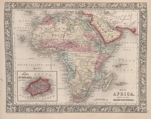
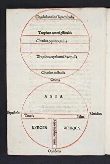
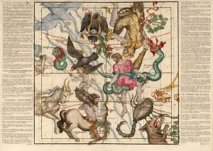
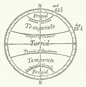
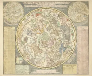
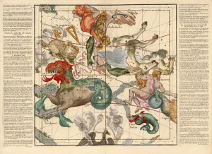
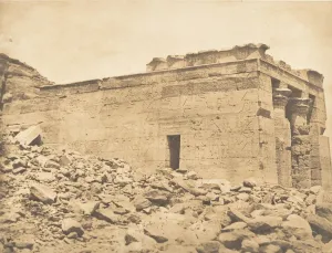
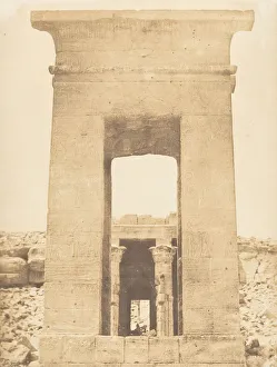
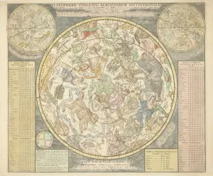
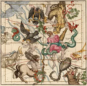
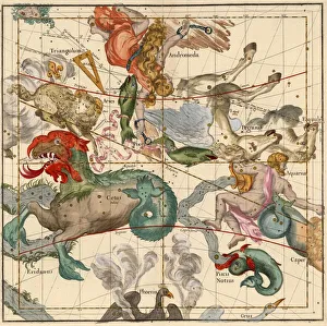
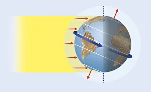
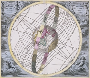
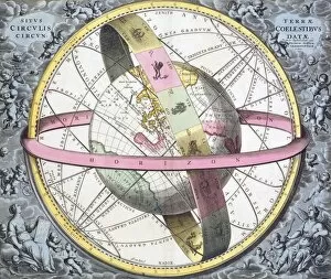
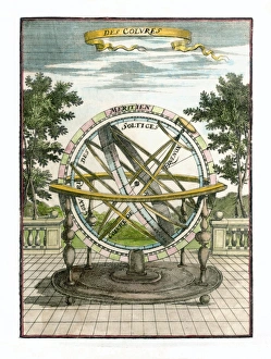
"Exploring the Tropic of Cancer: A Journey through Discoveries, Slavery, and Celestial Wonders" Embark on a captivating journey as we delve into the significance of the Tropic of Cancer. This map of Africa showcases its most recent discoveries, highlighting the Island of St. Immerse yourself in history with a chart illustrating the impolicy of slavery, published in 1820. Transporting us back to 1493 Florence, a mesmerizing map and diagram from Orbis Breviarium by Zaccaria Lilio unfolds before our eyes. Witness the enchantment of Winter Solstice captured in Plate 5 from Globi coelestis in tabulas planas redacti descriptio. As we traverse further along this imaginary line, encounter an intriguing engraving depicting different zones. Marvel at flying fish and tuna chasing their prey amidst the Tropic of Cancer's waters. The celestial wonders continue to astound with Planisphaerii Coelestis Hemisphaerium Septentrionale from Atlas Coelestis unveiling before us. Delve into ancient navigation charts showcasing China, Ceylon, and Philippines alongside the Tropics of Cancer and Capricorn dating back to c. 1540. Plate 2 from Globi coelestis brings forth Vernal Equinox's splendor as it graces our presence once more. Step into April 7th, 1850 with Vue du pronaos du Temple de Dandour (Tropique du Cancer), capturing breathtaking views that leave us awestruck. Maxime du Camp takes us on an immersive visual journey through his lens with Propylon du Temple de Dandour (Tropique du Cancer) and Vue prise au Village d Abou-hor (Tropique du Cancer). These photographs transport us directly to these remarkable locations during April 1850.