Home > Asia > China > China Heritage Sites > The Grand Canal
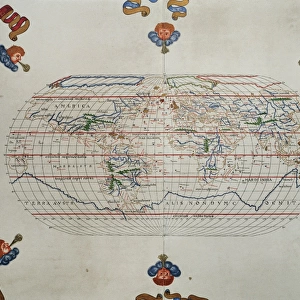
CHINA: MAP, 1375. Detail from the Catalan Atlas, 1375, showing China and the Grand

![]()
Wall Art and Photo Gifts from Granger
CHINA: MAP, 1375. Detail from the Catalan Atlas, 1375, showing China and the Grand
CHINA: MAP, 1375.
Detail from the Catalan Atlas, 1375, showing China and the Grand Canal
Granger holds millions of images spanning more than 25,000 years of world history, from before the Stone Age to the dawn of the Space Age
Media ID 12321241
Canal China Chinese Detail Emperor Geography Grand Canal Portolan Chart 1375 Catalan Atlas
FEATURES IN THESE COLLECTIONS
> Asia
> China
> China Heritage Sites
> The Grand Canal
> Granger Art on Demand
> Maps
> Maps and Charts
> Related Images
EDITORS COMMENTS
This print titled "CHINA: MAP, 1375" takes us back in time to the late 14th century, offering a glimpse into the intricate details of the Catalan Atlas. The image showcases an exquisite detail from this historical masterpiece, focusing on China and its remarkable Grand Canal. The map itself is a testament to the artistry and precision of cartography during that era. Every stroke and line meticulously crafted to depict the vast Chinese landscape with utmost accuracy. It provides a fascinating insight into how people perceived geography at that time. The Grand Canal steals our attention as it snakes its way through China's terrain like a lifeline connecting various cities and regions. This monumental feat of engineering was not only crucial for transportation but also played a significant role in shaping China's economic growth throughout history. In this particular detail, we see a man standing near the canal, perhaps an emperor or an ordinary citizen marveling at its grandeur. His presence adds depth to the image, reminding us of the human element behind these incredible achievements. As we admire this print from Granger Art on Demand's Carousel Collection, we are transported back centuries ago when maps were hand-drawn works of art rather than digital renderings. It serves as both a visual delight and educational tool for anyone interested in Chinese history or cartography enthusiasts alike.
MADE IN AUSTRALIA
Safe Shipping with 30 Day Money Back Guarantee
FREE PERSONALISATION*
We are proud to offer a range of customisation features including Personalised Captions, Color Filters and Picture Zoom Tools
SECURE PAYMENTS
We happily accept a wide range of payment options so you can pay for the things you need in the way that is most convenient for you
* Options may vary by product and licensing agreement. Zoomed Pictures can be adjusted in the Cart.