Home > Arts > Artists > H > Lewis Hine
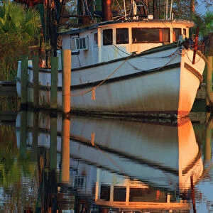
GULF COAST MAP, 1913. A map showing the location of the Oyster and Shrimp canneries of the Gulf

![]()
Wall Art and Photo Gifts from Granger
GULF COAST MAP, 1913. A map showing the location of the Oyster and Shrimp canneries of the Gulf
GULF COAST MAP, 1913.
A map showing the location of the Oyster and Shrimp canneries of the Gulf and South Atlantic Coast of America. Photograph of the map by Lewis Hine, 1913
Granger holds millions of images spanning more than 25,000 years of world history, from before the Stone Age to the dawn of the Space Age
Media ID 12319787
1913 Atlantic Atlantic Ocean Cannery Coast Gulf Gulf Of Mexico Hine Industry Lewis Northeast Oyster Shrimp State United States Wickes Shellfish Southeast
FEATURES IN THESE COLLECTIONS
> Animals
> Crustaceans
> Shrimp
> Animals
> Mollusks
> Oysters
> Arts
> Artists
> H
> Lewis Hine
> Arts
> Artists
> H
> Lewis Hines
> Granger Art on Demand
> Maps
> Maps and Charts
> Early Maps
> North America
> Mexico
> Maps
EDITORS COMMENTS
This print showcases a historical treasure, the "GULF COAST MAP, 1913". A remarkable creation by Lewis Hine, this map unveils the precise locations of Oyster and Shrimp canneries along the Gulf and South Atlantic Coast of America. With its intricate details and expert craftsmanship, it offers a glimpse into an early era of American industry. The photograph captures the essence of this antique map with utmost clarity. Every contour line and label is meticulously preserved, allowing viewers to immerse themselves in the rich history it represents. The Granger Collection has masterfully reproduced this piece, ensuring that its beauty endures for generations to come. As we explore this map's intricacies, we are transported back to a time when oysters and shrimp were vital components of coastal economies. Each state along the Gulf Coast is marked with precision; from Texas to Florida, these regions thrived on their bountiful shellfish resources. Lewis Hine's work not only serves as a visual delight but also as an invaluable resource for historians and enthusiasts alike. It provides us with insights into how industries evolved over time while shedding light on America's relationship with its natural resources. Whether you are captivated by cartography or fascinated by American history, this stunning reproduction will undoubtedly be a cherished addition to your collection. Let yourself be transported back in time through "GULF COAST MAP, 1913" where every detail tells a story waiting to be discovered anew.
MADE IN AUSTRALIA
Safe Shipping with 30 Day Money Back Guarantee
FREE PERSONALISATION*
We are proud to offer a range of customisation features including Personalised Captions, Color Filters and Picture Zoom Tools
SECURE PAYMENTS
We happily accept a wide range of payment options so you can pay for the things you need in the way that is most convenient for you
* Options may vary by product and licensing agreement. Zoomed Pictures can be adjusted in the Cart.