Home > Europe > Italy > Lombardy > Milan
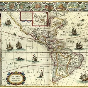
MAP OF AFRICA, 1508. The first printed map devoted primarily to the African continent

![]()
Wall Art and Photo Gifts from Granger
MAP OF AFRICA, 1508. The first printed map devoted primarily to the African continent
MAP OF AFRICA, 1508.
The first printed map devoted primarily to the African continent, published in 1508 in Milan, Italy
Granger holds millions of images spanning more than 25,000 years of world history, from before the Stone Age to the dawn of the Space Age
Media ID 12320985
1508 Africa African Middle East Ocean Ship
FEATURES IN THESE COLLECTIONS
> Africa
> Related Images
> Arts
> Landscape paintings
> Waterfall and river artworks
> River artworks
> Europe
> Italy
> Lombardy
> Milan
> Granger Art on Demand
> Maps
> Maps and Charts
> Early Maps
> Maps and Charts
> Italy
EDITORS COMMENTS
This print showcases the historic "Map of Africa, 1508" which holds the distinction of being the first printed map primarily dedicated to the African continent. Published in Milan, Italy, this remarkable piece offers a glimpse into early cartography and maritime exploration during the Renaissance era. The intricate details depicted on this map transport us back to a time when knowledge about Africa was still evolving. From its exterior borders to its vast oceanic expanse, every element has been meticulously crafted to provide an accurate representation of the continent's geography. Rivers meander through lush landscapes while ships navigate treacherous waters, symbolizing both trade routes and European expeditions that sought new discoveries. Notably, this map also encompasses regions beyond Africa itself. The Middle East is intricately woven into its narrative as it served as a crucial gateway for trade between Europe and Asia during that period. This inclusion highlights how interconnected these regions were in terms of commerce and cultural exchange. As we gaze upon this extraordinary artwork from Granger Art on Demand, we are reminded of humanity's insatiable curiosity and thirst for knowledge throughout history. It serves as a testament to our collective desire to explore uncharted territories and understand our place in the world—a timeless reminder that maps not only guide us physically but also ignite our imagination by revealing new possibilities waiting just beyond their edges.
MADE IN AUSTRALIA
Safe Shipping with 30 Day Money Back Guarantee
FREE PERSONALISATION*
We are proud to offer a range of customisation features including Personalised Captions, Color Filters and Picture Zoom Tools
SECURE PAYMENTS
We happily accept a wide range of payment options so you can pay for the things you need in the way that is most convenient for you
* Options may vary by product and licensing agreement. Zoomed Pictures can be adjusted in the Cart.