Fraud Blocker Skip to main content

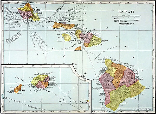
MAP: HAWAII, 1905. Map of the Hawaiian Islands printed in the United States in 1905

MAP: HAWAII, 1905. Map of the Hawaiian Islands printed in the United States in 1905
Sold 8
In Stock
We accept all major payment options so you can pay for the things you need in the way that is most convenient for you

Granger Photo Prints and Wall Art

MAP: HAWAII, 1905. Map of the Hawaiian Islands printed in the United States in 1905

MAP: HAWAII, 1905. Map of the Hawaiian Islands printed in the United States in 1905. Granger holds millions of images spanning more than 25,000 years of world history, from before the Stone Age to the dawn of the Space Age.

Media ID 6620087

1905 Hawaii Island Pacific Ocean Polynesia Polynesian

SECURE PAYMENTS
We accept all major payment options so you can pay for the things you need in the way that is most convenient for you

Made in Australia
Safe Shipping, Easy Returns

FREE PERSONALISATION
We are proud to offer a range of customisation including Cropping, Captions, and Filters. Zoom Cropping can be adjusted in the basket


EDITORS COMMENTS

This print takes us back in time to the year 1905, showcasing a meticulously detailed map of the enchanting Hawaiian Islands. Created and printed in the United States, this vintage piece offers a glimpse into an era when cartography was both an art form and a scientific endeavor. The map itself is a testament to the skill and precision of its creators, capturing every intricate detail of Hawaii's diverse topography. From lush mountains to winding rivers, it paints a vivid picture of this Polynesian paradise nestled in the vast expanse of the Pacific Ocean. As we explore this historical artifact, we are transported to an early period where Hawaii's rich cultural heritage thrived. The islands' indigenous Polynesian roots are beautifully represented through their names and landmarks on the map – reminding us that these lands have been cherished by generations long before Western influence arrived. With its vibrant colors and fine craftsmanship, this Granger Collection print captures not only geographical accuracy but also serves as a visual tribute to Hawaii's unique allure. It invites viewers to embark on an imaginary journey through time, immersing themselves in the natural beauty that has made these islands so beloved throughout history. Whether you're an avid traveler or simply fascinated by history, this remarkable image allows you to admire Hawaii from afar while appreciating how far cartography has come since its creation over a century ago.


Framed Prints

Discover the rich history of Hawaii with our exquisite Framed Prints from Media Storehouse. This captivating piece features a rare and vintage map of the Hawaiian Islands, dated back to 1905. Meticulously sourced from The Granger Collection through Granger Art on Demand, this map offers a unique glimpse into the past, showcasing the islands as they were depicted over a century ago. The intricate details and vibrant colors of this antique map are brought to life in a beautifully framed presentation, making it an exceptional addition to any home or office space. Transport yourself back in time and add a touch of historical charm to your décor with our Framed Print of "MAP: HAWAII, 1905. Map of the Hawaiian Islands printed in the United States in 1905."


Photo Prints

Discover the rich history of Hawaii with our exquisite Media Storehouse Photographic Print of the "MAP: HAWAII, 1905" from The Granger Collection. This vintage map, printed in the United States in 1905, offers a captivating glimpse into the past as it depicts the Hawaiian Islands in intricate detail. With the allure of the islands' geography and the nostalgia of a bygone era, this photographic print is an essential addition to any home or office space. Bring history to life with the authentic and timeless beauty of this rare and captivating piece. Order now from Media Storehouse and let the stories of Hawaii's past unfold in your own space.


Poster Prints

Discover the rich history of Hawaii with our stunning vintage poster print from Media Storehouse. This beautiful map, titled "MAP: HAWAII, 1905," showcases the Hawaiian Islands as they appeared over a century ago. Printed in the United States in 1905 from The Granger Collection through Granger Art on Demand, this poster is a captivating addition to any home or office. Travel back in time and explore the islands' intriguing past with this unique and intriguing piece of historical cartography. Bring a piece of history into your space and ignite the imagination with Media Storehouse's vintage poster prints.


Jigsaw Puzzles

Discover the rich history of Hawaii with the Media Storehouse Jigsaw Puzzle featuring the vintage "MAP: HAWAII, 1905" print from The Granger Collection. This intricately detailed puzzle showcases an antique map of the Hawaiian Islands as they appeared over a century ago. Printed in the United States in 1905, this puzzle is a captivating journey back in time. Immerse yourself in the beauty and culture of the islands as you piece together this intriguing jigsaw puzzle, perfect for history enthusiasts, puzzle collectors, or anyone in search of a challenging and engaging activity. Let the adventure begin!

diamond
Made With High Grade Materials
thumb_up
Professional Quality Finish
package_2
Carefully Packed To Aid Safe Arrival

You May Also Like


Map of Hawaiian islands 1883Map of Hawaiian islands 1883
Add to Basket
Map of Hawaii, 1870sMap of Hawaii, 1870s
Add to Basket
Dark matter mapDark matter map
Add to Basket
Map of Nueva Espa񡠨1767) by Jos頁ntonio AlzateMap of Nueva Espa񡠨1767) by Jos頁ntonio Alzate
Add to Basket
United States map 1881United States map 1881
Add to Basket
California Highway MapCalifornia Highway Map
Add to Basket
San Diego, California area mapSan Diego, California area map
Add to Basket
Los Angeles City MapLos Angeles City Map
Add to Basket
San Francisco City MapSan Francisco City Map
Add to Basket
Fountains and buildings in city of StFountains and buildings in city of St
Add to Basket
Kolo Toure (Arsenal) Bolo Zenden (Liverpool)Kolo Toure (Arsenal) Bolo Zenden (Liverpool)
Add to Basket
Wast Water, Lake District J060226Wast Water, Lake District J060226
Add to Basket

Gallery Wall Inspiration

MAP: PHILIPPINES, 1905. Map of the Philippine Islands printed in the United States in 1905
MAP: SCOTLAND. Line engraving, 19th century
MAP: BRITISH EMPIRE, 1886. Map, 1886, of the British Empire by Walter Crane
MAP OF ITALY, c1585. By Ignazio Danti from Sistine Chapel Gallery of Maps
MAP: JAMAICA, 1893. British map of Jamaica by Colin Liddell, published 1893
MAP OF FRANCE, c1900. With inset detail of Paris and surrounding area
MAP: HAWAII, 1905. Map of the Hawaiian Islands printed in the United States in 1905
MAP OF MACEDONIAN EMPIRE. Map of the Macedonian Empire following the conquests of Alexander the Great, 4th
MAP: CUBA, 1900. Map of Cuba printed in the United States, c1900
MAP: IRELAND, 1851. An engraved map of Ireland, 1851
PLYMOUTH, MA, MAP 1605. Samuel de Champlains map of Port St. Louis, later settled by the English as Plymouth, Massachusetts, drawn during an expedetion of 1605
VESPUCCIs WORLD MAP, 1526. Juan Vespuccis world map, 1526
STRABO WORLD MAP, c20 A. D. According to the writings of the Greek geographer Strabo
WORLD MAP, 11th CENTURY. The Cottonian or Anglo-Saxon World Map
VENICE: MAP, 17TH CENTURY. Map of Venice by Guiseppe Heintz, 17th century
WORLD MAP. Pre-Christian era, c450 B. C. according to the writings of Herodotus
MADABA MAP, 6TH CENTURY. The Madaba Mosaic Map, the oldest known map of the city of Jerusalem
CONSTELLATION MAP. An Indian Sanskrit star map, 1840, ordered as a manuscript horoscope for Prince
MAP: UNITED STATES, 1905. Map of the continental United States (excluding Alaska), 1905
TENOCHTITLAN (MEXICO CITY) at the time of the Spanish Conquest: colored woodcut, 1556
CARIBBEAN MAP. A map of the Caribbean islands: woodcut, French, c. 1688
AFRICA: MAP. Birds eye view of the Sudan and surrounding countries
CANTINO WORLD MAP, 1502. Western half of the Cantino map of the world
ICELAND: MAP, 1595. Map of Iceland from a 1595 edition of Abraham Ortelius atlas Theatrum
ST. BRENDAN: MASS. St. Brendan and his monks celebrate Mass on the back of a whale


© Copyright Media Storehouse, All Rights Reserved 2003 - 2024
Facebook     Pinterest     100% Payment Secure     Reviews IO