Home > North America > United States of America > New York > New York > Maps
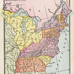
NORTHWEST TERRITORY, 1787. Map of the Northwest Territory as it appeared after

![]()
Wall Art and Photo Gifts from Granger
NORTHWEST TERRITORY, 1787. Map of the Northwest Territory as it appeared after
NORTHWEST TERRITORY, 1787.
Map of the Northwest Territory as it appeared after the promulgation of the Northwest Ordinance of 1787
Granger holds millions of images spanning more than 25,000 years of world history, from before the Stone Age to the dawn of the Space Age
Media ID 12319632
1787 Border Canada Great Lakes Illinois Indiana Iowa Kentucky Louisiana Michigan New York North Carolina Northwest Northwest Territory Ohio Ohio River Ordinance Pennsylvania Tennessee United States Virginia West Virginia Southeast
FEATURES IN THESE COLLECTIONS
> Arts
> Landscape paintings
> Waterfall and river artworks
> River artworks
> Granger Art on Demand
> Maps
> North America
> Canada
> Lakes
> Related Images
> North America
> Canada
> Maps
> North America
> United States of America
> New York
> New York
> Maps
EDITORS COMMENTS
This print showcases a historical map of the Northwest Territory in 1787, after the implementation of the groundbreaking Northwest Ordinance. The intricate details and vibrant colors bring to life this significant moment in American history. The map encompasses an expansive region, stretching from present-day states such as Ohio, Indiana, Illinois, Michigan, and Wisconsin all the way up to Canada. It highlights key geographical features like the Great Lakes and the Ohio River that played crucial roles in shaping trade routes and settlement patterns during that era. The Northwest Ordinance of 1787 was a pivotal document that established principles for governing this vast territory. It provided a blueprint for future statehood by guaranteeing certain rights to settlers while also prohibiting slavery within these new territories. As we gaze upon this remarkable piece of cartography, it serves as a reminder of America's westward expansion during its formative years. It symbolizes both hope and challenges faced by early pioneers who ventured into uncharted lands seeking new opportunities. Whether you are an avid history enthusiast or simply appreciate fine artistry, this print is sure to captivate your imagination with its rich historical significance. Let it transport you back in time to an era when boundaries were being redrawn and dreams were taking shape across the vast expanse known as the Northwest Territory.
MADE IN AUSTRALIA
Safe Shipping with 30 Day Money Back Guarantee
FREE PERSONALISATION*
We are proud to offer a range of customisation features including Personalised Captions, Color Filters and Picture Zoom Tools
SECURE PAYMENTS
We happily accept a wide range of payment options so you can pay for the things you need in the way that is most convenient for you
* Options may vary by product and licensing agreement. Zoomed Pictures can be adjusted in the Cart.