Home > Europe > United Kingdom > England > London > Art > Theatre
Allied positions on the Gallipoli peninsula in Turkey, First World War, July 1915, (c1920)
")
![]()
Wall Art and Photo Gifts from Heritage Images
Allied positions on the Gallipoli peninsula in Turkey, First World War, July 1915, (c1920)
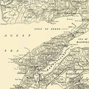
Allied positions on the Gallipoli peninsula in Turkey, First World War, July 1915, (c1920). The Operations in the Southern Area of Gallipoli: Map showing approximately the Allies Line at the close of the fighting. Positions of British and French forces, and strategic points in the unsuccessful campaign against Turkey by allied forces. From " The Great World War - A History" Volume III, edited by Frank A Mumby. [The Gresham Publishing Company Ltd, London, c1920]
Heritage Images features heritage image collections
Media ID 19175551
© The Print Collector/Heritage Images
Aegean Sea Beach Canakkale Province Dardanelles Dardanelles Campaign Frank Arthur Frank Arthur Mumby Gallipoli Campaign Gallipoli Peninsula Gallipoli Peninsula Turkey Gresham Publishing Co Ltd Gresham Publishing Company Hellespont Keystone Archives Mumby Mumby Frank Arthur Sedd El Bahr Strait The Great World War A History Theatre Of War Turkey 1st World War
FEATURES IN THESE COLLECTIONS
> Asia
> Turkey
> Related Images
> Europe
> France
> Canton
> Allier
> Europe
> United Kingdom
> England
> London
> Art
> Theatre
> Historic
> World War I and II
> World War I
> Historic
> World War I and II
> Maps and Charts
> World
EDITORS COMMENTS
This print captures the Allied positions on the Gallipoli peninsula in Turkey during the First World War. Taken in July 1915, this image provides a glimpse into the strategic points and locations of British and French forces during their unsuccessful campaign against Turkey. The black and white composition adds a sense of historical significance to this snapshot from one of the most devastating conflicts in human history. The map depicted here showcases approximately where the Allies' line stood at the close of fighting, offering valuable insights into their positioning along the coastline. The rugged coastal terrain, with its picturesque beaches and cliffs, serves as a stark contrast to the grim reality faced by soldiers who fought bravely amidst these challenging conditions. Published in "The Great World War - A History". Volume III, edited by Frank A Mumby, this photograph is an invaluable piece of historical documentation that sheds light on an important chapter in global warfare. It transports us back to a time when nations clashed over control of key territories like Gallipoli Peninsula and Dardanelles Strait. As we reflect upon this image today, it reminds us not only of the sacrifices made by those who fought but also serves as a reminder that war leaves lasting imprints on both landscapes and people alike.
MADE IN AUSTRALIA
Safe Shipping with 30 Day Money Back Guarantee
FREE PERSONALISATION*
We are proud to offer a range of customisation features including Personalised Captions, Color Filters and Picture Zoom Tools
SECURE PAYMENTS
We happily accept a wide range of payment options so you can pay for the things you need in the way that is most convenient for you
* Options may vary by product and licensing agreement. Zoomed Pictures can be adjusted in the Cart.