Home > Europe > France > Maps
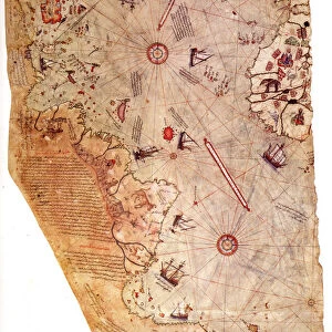
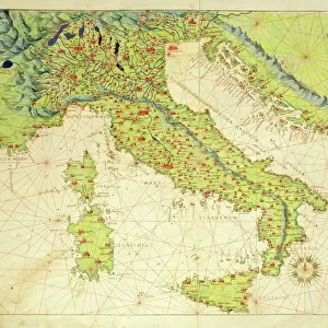
Carta Pisana, ca 1275-1300. Artist: Anonymous master

![]()
Wall Art and Photo Gifts from Heritage Images
Carta Pisana, ca 1275-1300. Artist: Anonymous master
Carta Pisana, ca 1275-1300. Found in the collection of the Bibliotheque Nationale de France
Heritage Images features heritage image collections
Media ID 15015616
© Fine Art Images
Anonymous Master Cartography Chart Ink On Parchment Nautical Chart Portolan Portolan Chart
FEATURES IN THESE COLLECTIONS
> Maps and Charts
> Related Images
EDITORS COMMENTS
This print showcases the remarkable Carta Pisana, a masterpiece of cartography created by an anonymous master between 1275 and 1300. Housed in the prestigious collection of the Bibliotheque Nationale de France, this ancient nautical chart is a testament to the ingenuity and precision of early mapmakers. Rendered meticulously with ink on parchment, every intricate detail comes to life in this fine art image. The Carta Pisana offers a glimpse into history, transporting us back to an era when seafaring was both treacherous and adventurous. Its purpose as a navigational tool for sailors becomes evident through its carefully plotted coastlines, ports, and sea routes. As we delve deeper into this portolan chart's composition, we are captivated by its graphic arts elements that seamlessly blend practicality with aesthetic beauty. Each stroke tells a story of exploration and discovery; each contour represents countless journeys across uncharted waters. The anonymity of the artist only adds to the mystique surrounding this extraordinary piece. Their skillful craftsmanship has stood the test of time, leaving behind an enduring legacy that continues to inspire contemporary cartographers. This print serves as a reminder not only of our shared human history but also of our innate curiosity about the world around us. It invites us to marvel at how knowledge was once painstakingly recorded on such delicate materials like parchment—a true testament to human perseverance and intellectual prowess.
MADE IN AUSTRALIA
Safe Shipping with 30 Day Money Back Guarantee
FREE PERSONALISATION*
We are proud to offer a range of customisation features including Personalised Captions, Color Filters and Picture Zoom Tools
SECURE PAYMENTS
We happily accept a wide range of payment options so you can pay for the things you need in the way that is most convenient for you
* Options may vary by product and licensing agreement. Zoomed Pictures can be adjusted in the Cart.