Home > Europe > United Kingdom > England > London > Sights > London Eye
Map of the Dardanelles, First World War, 1915, (c1920). Creator: Unknown
. Creator: Unknown")
![]()
Wall Art and Photo Gifts from Heritage Images
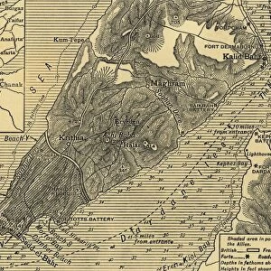
Map of the Dardanelles, First World War, 1915, (c1920). Creator: Unknown
Map of the Dardanelles, First World War, 1915, (c1920). Bird s-eye View of the Dardanelles from the Entrance to the Straits to the Narrows. From " The Great World War - A History" Volume III, edited by Frank A Mumby. [The Gresham Publishing Company Ltd, London, c1920]
Heritage Images features heritage image collections
Media ID 19175361
© The Print Collector/Heritage Images
Aerial View Dardanelles Dardanelles Campaign Frank Arthur Frank Arthur Mumby George Philip And Son George Philip And Son Ltd Gresham Publishing Co Ltd Gresham Publishing Company Hellespont Keystone Archives London Geographical Institute Mumby Mumby Frank Arthur Philip Strait The Great World War A History Theatre Of War Turkey 1st World War
FEATURES IN THESE COLLECTIONS
> Aerial Photography
> Related Images
> Asia
> Turkey
> Related Images
> Europe
> United Kingdom
> England
> London
> Art
> Theatre
> Europe
> United Kingdom
> England
> London
> Related Images
> Europe
> United Kingdom
> England
> London
> Sights
> London Eye
> Historic
> World War I and II
> World War I
> Historic
> World War I and II
> Maps and Charts
> Related Images
EDITORS COMMENTS
This print showcases a historically significant map of the Dardanelles during the First World War. Taken from "The Great World War - A History". Volume III, edited by Frank A Mumby, this aerial view provides a bird's-eye perspective of the strategic region. The Dardanelles campaign was a crucial theater of war in which various nations fought for control over this narrow strait connecting the Aegean Sea to the Sea of Marmara. The creator of this remarkable piece remains unknown, but their attention to detail is evident as they depict not only the geographical features but also the mountains surrounding this vital waterway. Published around 1920 by The Gresham Publishing Company Ltd in London, it serves as an invaluable historical artifact that sheds light on one of the most significant conflicts in modern history. With its intricate depiction and accurate representation, this map offers viewers a glimpse into an era defined by turmoil and conflict. It stands as a testament to human resilience and determination during times of war. Whether you are an avid historian or simply intrigued by world events, this print transports you back to a pivotal moment in time when nations clashed for supremacy amidst breathtaking natural landscapes.
MADE IN AUSTRALIA
Safe Shipping with 30 Day Money Back Guarantee
FREE PERSONALISATION*
We are proud to offer a range of customisation features including Personalised Captions, Color Filters and Picture Zoom Tools
SECURE PAYMENTS
We happily accept a wide range of payment options so you can pay for the things you need in the way that is most convenient for you
* Options may vary by product and licensing agreement. Zoomed Pictures can be adjusted in the Cart.