Home > Arts > Artists > O > Oceanic Oceanic
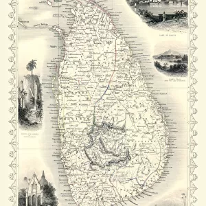
Map of India, 1847

![]()
Wall Art and Photo Gifts from Heritage Images
Map of India, 1847
Map of India, 1847. Illustration from The History of China and India, by Miss Corner, (Dean and Co, London, 1847)
Heritage Images features heritage image collections
Media ID 14935408
© The Print Collector / Heritage-Images
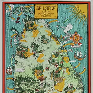
Bay Of Bengal Ceylon Corner Indian Ocean Julia Julia Corner Julia Parley Lovechild Miss Corner Miss Julia Pakistan Parley Solomon Solomon Lovechild Sri Lanka Thomas Lovechild Thomas Parley Tibet British Empire Hindoostan
FEATURES IN THESE COLLECTIONS
> Arts
> Artists
> O
> Oceanic Oceanic
> Asia
> India
> Related Images
> Asia
> Pakistan
> Related Images
> Asia
> Sri Lanka
> Related Images
> Maps and Charts
> British Empire Maps
EDITORS COMMENTS
This print showcases a Map of India from the year 1847, taken from "The History of China and India" by Miss Corner. The intricate engraving highlights the vastness and diversity of this ancient land during the 19th century. The map encompasses not only present-day India but also Pakistan, Tibet, Sri Lanka (then known as Ceylon), and various coastal regions along the Indian Ocean and Bay of Bengal. Created by an unknown artist, this monochrome illustration provides a glimpse into the British Empire's influence in India at that time. It serves as a historical artifact depicting the geographical boundaries and locations within Hindoostan. The names Julia Corner, Solomon Lovechild, Thomas Parley, among others mentioned in association with this print add an intriguing layer to its provenance. The level of detail captured in this print is remarkable; it allows viewers to explore different regions' topography and understand their significance within Indian history. Whether used for educational purposes or simply admired for its aesthetic appeal, this Map of India offers a window into a bygone era when colonial powers were shaping nations across continents. As we gaze upon this vintage treasure brought to us by Heritage Images, we are reminded of how maps can transcend time—connecting us to our past while guiding us towards an enlightened future.
MADE IN AUSTRALIA
Safe Shipping with 30 Day Money Back Guarantee
FREE PERSONALISATION*
We are proud to offer a range of customisation features including Personalised Captions, Color Filters and Picture Zoom Tools
SECURE PAYMENTS
We happily accept a wide range of payment options so you can pay for the things you need in the way that is most convenient for you
* Options may vary by product and licensing agreement. Zoomed Pictures can be adjusted in the Cart.