Home > North America > United States of America > New York > New York > Maps
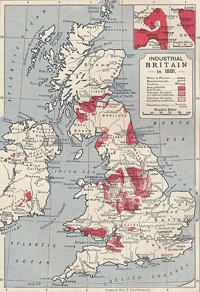
Map of industrial Britain in 1881, 1906
![]()

Wall Art and Photo Gifts from Heritage Images
Map of industrial Britain in 1881, 1906
Map of industrial Britain in 1881, 1906. From Cassells Illustrated History of England, Vol. VII. [Cassell and Company, Limited, London, Paris, New York & Melbourne, 1906]
Heritage Images features heritage image collections
Media ID 14967026
© The Print Collector
British Isles Coal Industry Economy Industrialisation Manufacturing Coalfield
FEATURES IN THESE COLLECTIONS
> Europe
> France
> Paris
> Maps
> Europe
> United Kingdom
> England
> Maps
> Europe
> United Kingdom
> England
> York
> Maps and Charts
> Related Images
> North America
> United States of America
> New York
> New York
> Maps
> North America
> United States of America
> New York
> Related Images
EDITORS COMMENTS
This print showcases the Map of industrial Britain in 1881,1906. Taken from Cassells Illustrated History of England, Vol. VII, this historical artifact offers a fascinating glimpse into the economic landscape of Victorian-era Britain. The intricate details and vibrant colors bring to life the country's flourishing agriculture, industry, and manufacturing sectors during this pivotal period. The map highlights the strategic locations where trade thrived and British goods were produced with remarkable efficiency. It depicts the coalfields that fueled Britain's industrial revolution, symbolizing the nation's dominance in coal production during the 19th century. This visual representation serves as a testament to how these resources shaped not only Britain's economy but also its global influence. As we delve into this piece of history, it becomes evident that every inch of land on this map played a vital role in shaping industrialization across the British Isles. The print collector has masterfully captured both the geographical layout and economic significance of each region depicted. With its rich historical context and stunning visual appeal, this print transports us back to an era when Britain was at the forefront of innovation and progress. It serves as a reminder of our shared heritage and invites us to reflect on how far we have come since those transformative times.
MADE IN AUSTRALIA
Safe Shipping with 30 Day Money Back Guarantee
FREE PERSONALISATION*
We are proud to offer a range of customisation features including Personalised Captions, Color Filters and Picture Zoom Tools
SECURE PAYMENTS
We happily accept a wide range of payment options so you can pay for the things you need in the way that is most convenient for you
* Options may vary by product and licensing agreement. Zoomed Pictures can be adjusted in the Cart.

