Home > Arts > Artists > A > John White Alexander
Poster Print : Map Showing the German Cameroon Colony, 1916. Creator: Unknown


![]()
Poster Prints from Heritage Images
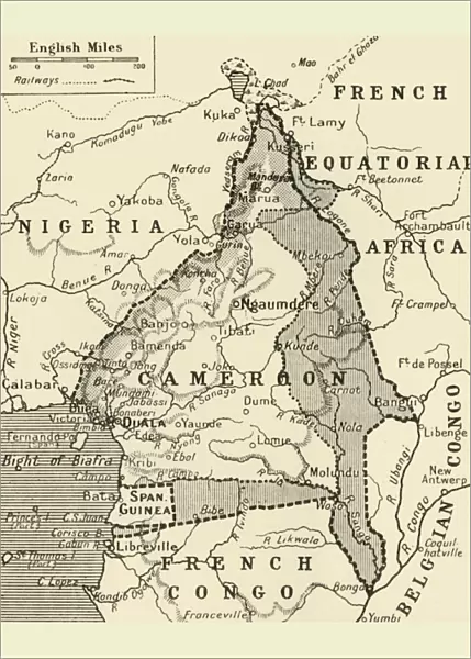
Map Showing the German Cameroon Colony, 1916. Creator: Unknown
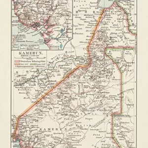
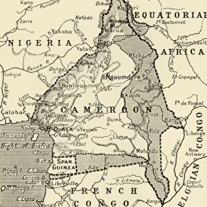
Map Showing the German Cameroon Colony, 1916. German Cameroon was an African colony of the German Empire from 1884 to 1916. Following Germanys defeat, the Treaty of Versailles divided the territory between Great Britain and France. From " The War Illustrated Album De Luxe - Volume IV. The Summer Campaign - 1915", edited by J. A. Hammerton. [The Amalgamated Press, Limited, London, 1916]
Heritage Images features heritage image collections
Media ID 19661303
© The Print Collector/Heritage Images
Album Amalgamated Press Amalgamated Press Limited Amalgamated Press Ltd Cameroon Congo Congo Africa Democratic Republic Of The Congo German Empire Hammerton Hammerton J A Hammerton Ja Hammerton Sir John Alexander J A Hammerton Ja Hammerton John Hammerton Nigeria Sir John Alexander Sir John Alexander Hammerton Sir John Hammerton Strategic Strategy Summer Campaign 1915 Territorial Territory The Amalgamated Press The War Illustrated
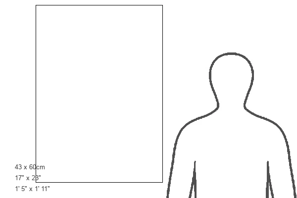
A2 (59.4 x 42cm) Poster Print
Step back in time with our vintage Map Showing the German Cameroon Colony, 1916 from Media Storehouse's extensive collection. This intriguing historical print, sourced from Heritage Images, depicts German Cameroon, an African colony of the German Empire from 1884 to 1916. With an unknown creator, this map offers a fascinating glimpse into the past, making it a must-have for history enthusiasts, collectors, or those looking to add a touch of antiquity to their decor. Bring a piece of history into your home or office with this captivating and mysterious Map of German Cameroon Colony, 1916.
Premium quality poster prints are printed on luxurious glossy or matte 270 gsm paper. Our meticulously crafted poster prints offer an affordable option for decorating any space, making them ideal for living rooms, bedrooms, offices and beyond. To ensure your poster arrives in good condition, we roll and send them in strong mailing tubes.
Poster prints are budget friendly enlarged prints in standard poster paper sizes (A0, A1, A2, A3 etc). Whilst poster paper is sometimes thinner and less durable than our other paper types, they are still ok for framing and should last many years. Our Archival Quality Photo Prints and Fine Art Paper Prints are printed on higher quality paper and the choice of which largely depends on your budget.
Estimated Product Size is 42.6cm x 59.6cm (16.8" x 23.5")
These are individually made so all sizes are approximate
Artwork printed orientated as per the preview above, with portrait (vertical) orientation to match the source image.
FEATURES IN THESE COLLECTIONS
> Africa
> Cameroon
> Related Images
> Africa
> Democratic Republic of the Congo
> Related Images
> Africa
> Nigeria
> Related Images
> Africa
> Republic of the Congo
> Maps
> Arts
> Artists
> A
> John White Alexander
> Arts
> Artists
> W
> John White
EDITORS COMMENTS
This print showcases a historical map titled "Map Showing the German Cameroon Colony, 1916". Created by an unknown artist, this map depicts the African colony of German Cameroon during its existence from 1884 to 1916. The German Empire ruled over this territory until their defeat in World War I, which led to the division of the region between Great Britain and France through the Treaty of Versailles. The photograph is sourced from "The War Illustrated Album De Luxe - Volume IV. The Summer Campaign - 1915" edited by J. A. Hammerton and published by The Amalgamated Press Limited in London in 1916. It captures a significant moment in history when colonial powers were vying for control over African territories. The map represents not only a geographical depiction but also symbolizes concepts such as colonialism, strategy, and territorial disputes. It highlights how Africa was divided among European powers during this period. Although we do not know who specifically created this map, it serves as a valuable historical artifact that sheds light on Germany's presence in Africa during the early 20th century. This image offers viewers an opportunity to explore the impact of World War I on global politics and colonization efforts at that time.
MADE IN AUSTRALIA
Safe Shipping with 30 Day Money Back Guarantee
FREE PERSONALISATION*
We are proud to offer a range of customisation features including Personalised Captions, Color Filters and Picture Zoom Tools
SECURE PAYMENTS
We happily accept a wide range of payment options so you can pay for the things you need in the way that is most convenient for you
* Options may vary by product and licensing agreement. Zoomed Pictures can be adjusted in the Cart.