Home > Europe > United Kingdom > England > London > Sport > Sailing
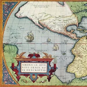
South America (America Meridionalis): from the Atlas of Gerardus Mercator, 1633, (1936). Artist: Gerardus Mercator
: from the Atlas of Gerardus Mercator, 1633, (1936). Artist: Gerardus Mercator")
![]()
Wall Art and Photo Gifts from Heritage Images
South America (America Meridionalis): from the Atlas of Gerardus Mercator, 1633, (1936). Artist: Gerardus Mercator
South America (America Meridionalis): from the Atlas of Gerardus Mercator, 1633, (1936). Published at Antwerp by Hondius From The Connoisseur, Vol. 98, edited by H. Granville Fell. [International Studio, London, 1936]
Heritage Images features heritage image collections
Media ID 14984985
© The Print Collector
Belgian Border Colourful Division Fell Gerardus H Granville H Granville Fell International Studio Latin Script Latin Text Mercator Navigation South American The Connoisseur Gerardus Mercator Inset
FEATURES IN THESE COLLECTIONS
> Animals
> Mammals
> Cricetidae
> Meridionalis
> Animals
> Mammals
> Sciuridae
> Meridionalis
> Arts
> Artists
> M
> Gerardus Mercator
> Arts
> Literature
> Magazines
> Europe
> Belgium
> Related Images
> Europe
> United Kingdom
> England
> London
> Sport
> Sailing
> Heritage Images
> Maps Charts & Plans
> Maps and Charts
> Gerardus Mercator's Cartographic
EDITORS COMMENTS
This print showcases a close-up view of South America, taken from the renowned Atlas of Gerardus Mercator in 1633. The print, published in Antwerp by Hondius and featured in The Connoisseur magazine, exudes a vibrant array of colors that bring the continent to life. With its rich hues and intricate detailing, this Belgian masterpiece captures the essence of South America's diverse landscapes and cultural heritage. The print is a testament to Mercator's exceptional cartographic skills as he meticulously delineates each country and border with precision. Latin script lettering adds an authentic touch to this seventeenth-century map, evoking a sense of historical significance. This piece serves as both an artistic creation and a navigational tool for sailors during that era. As we gaze upon this remarkable image, we are transported back to the thirties - a time when exploration was at its peak. The publication itself represents an intersection between centuries; merging elements from the seventeenth century with those of twentieth-century design. With its detailed inset maps and informative text, this print offers viewers not only visual pleasure but also valuable insights into South America's geography and topography. It stands as a testament to Mercator's enduring legacy as one of history's most influential cartographers.
MADE IN AUSTRALIA
Safe Shipping with 30 Day Money Back Guarantee
FREE PERSONALISATION*
We are proud to offer a range of customisation features including Personalised Captions, Color Filters and Picture Zoom Tools
SECURE PAYMENTS
We happily accept a wide range of payment options so you can pay for the things you need in the way that is most convenient for you
* Options may vary by product and licensing agreement. Zoomed Pictures can be adjusted in the Cart.