Home > Europe > United Kingdom > Scotland > Highlands > Alness
Maps and plans are spread on the sand, 1942 (1944)
")
![]()
Wall Art and Photo Gifts from Heritage Images
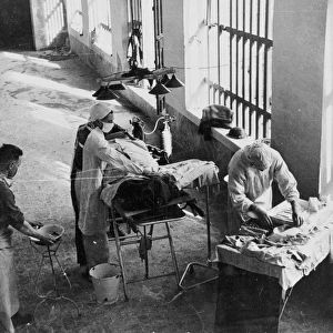
Maps and plans are spread on the sand, 1942 (1944)
Maps and plans are spread on the sand as the Brigadier takes his decisions and gives his orders, 1942 (1944). At the beginning of November 1942 the Eighth Army defeated Rommel in the decisive Second Battle of El Alamein, pursuing the defeated Axis army across Libya and reaching the Mareth defensive line on the Tunisian border in February 1943, where it came under the control of 18th Army Group. From The Eighth Army. [His Majestys Stationery Office, London, 1944]
Heritage Images features heritage image collections
Media ID 14972448
© The Print Collector
Al Alamayn Battle Of El Alamein Brigadier British Army Desert Desert Rats El Alamein Marsa Matruh Matrouh Matruh North Africa North Africa Campaign Planning Plans Sahara Sahara Desert 2nd World War Second World War World War 2 World War Two
FEATURES IN THESE COLLECTIONS
> Africa
> Libya
> Related Images
> Africa
> Related Images
> Africa
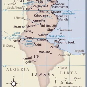
> Tunisia
> Related Images
> Animals
> Mammals
> Muridae
> Desert Mouse
> Animals
> Mammals
> Muridae
> Fortior
> Europe
> United Kingdom
> Scotland
> Highlands
> Alness
> Historic
> Battles
> Related Images
EDITORS COMMENTS
In this photograph taken in 1942, the scene is set amidst the vast expanse of the Sahara Desert. Maps and plans are meticulously spread out on the sandy terrain as a determined Brigadier takes charge, making critical decisions and issuing orders during a pivotal moment in history. The year is 1942, and the Eighth Army has just achieved a resounding victory over General Rommel's forces in the Second Battle of El Alamein. With their triumph, they relentlessly pursue the defeated Axis army across Libya, eventually reaching the formidable Mareth defensive line on Tunisia's border by February 1943. This image captures not only an intense military operation but also showcases human resilience against nature's harsh elements. The British officer stands tall amidst swirling sand particles, his gaze fixed upon maps that hold both strategic significance and hope for victory. As we observe this snapshot frozen in time, we are reminded of the immense challenges faced by those who fought during World War II. It serves as a testament to their unwavering determination to protect their homeland and secure freedom for future generations. This historic print offers us a glimpse into one chapter of North Africa's campaign during World War II—a period marked by bravery, sacrifice, and relentless pursuit of victory against all odds.
MADE IN AUSTRALIA
Safe Shipping with 30 Day Money Back Guarantee
FREE PERSONALISATION*
We are proud to offer a range of customisation features including Personalised Captions, Color Filters and Picture Zoom Tools
FREE COLORIZATION SERVICE
You can choose advanced AI Colorization for this picture at no extra charge!
SECURE PAYMENTS
We happily accept a wide range of payment options so you can pay for the things you need in the way that is most convenient for you
* Options may vary by product and licensing agreement. Zoomed Pictures can be adjusted in the Cart.