Home > Europe > Portugal > Maps
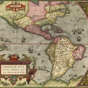
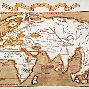
World Map (Propoganda), 1529. Artist: Ribeiro, Diogo (?-1533)
, 1529. Artist: Ribeiro, Diogo (?-1533)")
![]()
Wall Art and Photo Gifts from Heritage Images
World Map (Propoganda), 1529. Artist: Ribeiro, Diogo (?-1533)
World Map (Propoganda), 1529. Found in the collection of the Biblioteca Apostolica Vaticana
Heritage Images features heritage image collections
Media ID 15015622
© Fine Art Images
Biblioteca Apostolica Vaticana Cartography Chart Ink On Parchment Nautical Chart Portolan Portolan Chart Portugal
FEATURES IN THESE COLLECTIONS
> Europe
> Portugal
> Related Images
> Maps and Charts
> Related Images
> Maps and Charts
> World
EDITORS COMMENTS
This print showcases the "World Map (Propaganda)" created by Diogo Ribeiro in 1529. The artist, whose birth and death dates remain uncertain, crafted this remarkable piece that now resides in the esteemed collection of the Biblioteca Apostolica Vaticana. The map itself is a testament to Ribeiro's mastery of cartography and graphic arts. Inked on parchment with intricate details, it offers a glimpse into the world as understood during the early 16th century. With Portugal at its center, this portolan chart provides an invaluable historical record of nautical routes and geographical knowledge from that era. Ribeiro's World Map also bears elements of propaganda, reflecting the political climate of his time. It subtly promotes Portuguese exploration and colonization efforts across distant lands through carefully placed symbols and imagery. This artistic approach adds depth to an already visually stunning creation. As we admire this fine art image today, we are transported back in time to an age when maps were not just functional tools but works of art themselves. The delicate craftsmanship displayed here reminds us of humanity's enduring curiosity about our planet and our relentless pursuit to understand it better. With its rich history and undeniable beauty, this World Map (Propaganda) continues to captivate viewers centuries after its creation – a testament to both Ribeiro's skill as an artist and his contribution to the field of cartography.
MADE IN AUSTRALIA
Safe Shipping with 30 Day Money Back Guarantee
FREE PERSONALISATION*
We are proud to offer a range of customisation features including Personalised Captions, Color Filters and Picture Zoom Tools
SECURE PAYMENTS
We happily accept a wide range of payment options so you can pay for the things you need in the way that is most convenient for you
* Options may vary by product and licensing agreement. Zoomed Pictures can be adjusted in the Cart.