Home > Africa > Ethiopia (Abyssinia) > Maps
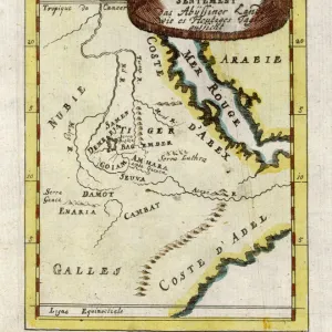
1690, Coronelli Map of Ethiopia, Abyssinia, and the Source of the Blue Nile, topography

![]()
Wall Art and Photo Gifts from Liszt Collection
1690, Coronelli Map of Ethiopia, Abyssinia, and the Source of the Blue Nile, topography
1690, Coronelli Map of Ethiopia, Abyssinia, and the Source of the Blue Nile
Liszt Collection of nineteenth-century engravings and images to browse and enjoy
Media ID 14004463
© Artokoloro Quint Lox Limited
1690 Abyssinia Antique Map Atlas Chart Geographic Latitude Longitude Mappa Mundi Old Antique Plan Old Antique View Old Map Ols Antique Map Rare Old Maps Topo
FEATURES IN THESE COLLECTIONS
> Africa
> Ethiopia (Abyssinia)
> Maps
> Africa
> Ethiopia
> Related Images
> Maps and Charts
> Early Maps
> Maps and Charts
> World
EDITORS COMMENTS
This print showcases the intricate beauty of the 1690 Coronelli Map of Ethiopia, Abyssinia, and the Source of the Blue Nile. With its rich topography and detailed cartography, this vintage map offers a fascinating glimpse into the geography and history of this ancient region. The map's delicate lines and precise grid reveal latitude and longitude coordinates, allowing viewers to navigate through Ethiopia's diverse landscapes. Its artistic illustrations depict various landmarks, highlighting both natural wonders and man-made structures that once defined this part of Africa. As an antique piece, this map holds immense historical value. It serves as a testament to centuries-old exploration and discovery efforts in uncharted territories. The aged paper adds a touch of nostalgia while evoking a sense of wonder about past civilizations' understanding of our world. Beyond its decorative appeal, this Coronelli Map invites us on a journey through time. It sparks curiosity about how our perception of Earth has evolved over centuries. This rare artifact is not only an invaluable resource for historians but also an exquisite piece for art enthusiasts who appreciate the fusion between science and aesthetics. Whether displayed in homes or educational institutions, this print from Liszt Collection transports us back to an era when maps were gateways to new frontiers—a reminder that even in today's modern age, there is still much left to explore within ourselves and our planet.
MADE IN AUSTRALIA
Safe Shipping with 30 Day Money Back Guarantee
FREE PERSONALISATION*
We are proud to offer a range of customisation features including Personalised Captions, Color Filters and Picture Zoom Tools
SECURE PAYMENTS
We happily accept a wide range of payment options so you can pay for the things you need in the way that is most convenient for you
* Options may vary by product and licensing agreement. Zoomed Pictures can be adjusted in the Cart.