Fraud Blocker Skip to main content

Home > Europe > France > Maps

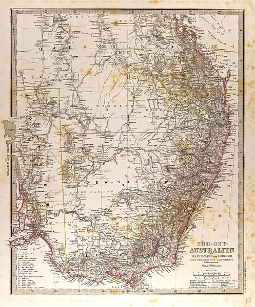
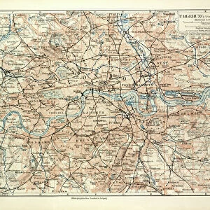
Australia Map Gotha, Justus Perthes, 1872, Atlas

Australia Map Gotha, Justus Perthes, 1872, Atlas
Sold 1
In Stock
We accept all major credit cards
Framed Photos
Buy from AU$119.99
Photo Prints
Buy from AU$12.99
Jigsaw Puzzles
Buy from AU$89.99
Poster Prints
Buy from AU$24.99
Canvas Prints
Buy from AU$124.99
Fine Art Prints
Buy from AU$92.53
Metal Prints
Buy from AU$43.99
Cards
Buy from AU$12.99
Home Decor
Buy from AU$24.99

Liszt Collection Photo Prints and Wall Art

Australia Map Gotha, Justus Perthes, 1872, Atlas

Australia Map Gotha, Justus Perthes, 1872, Atlas. Perthes, Johan Georg Justus 1749 aa 1816, German publisher, was born in Rudolstadt in 1749. In 1785 he founded at Gotha the business which bears his name, Justus Perthes. In this he was joined in 1814 by his son Wilhelm, 1793 aa 1853. He laid the foundation of the Geographical Branch of the business, for which it is chiefly famous, by publishing the and-Atlas (1817-1823) of Adolf Stieler (1775-1836). Wilhelm Perthes engaged the collaboration of the most eminent German geographers of the time, including Heinrich Berghaus, Christian Gottlieb Reichard, Karl Spruler and Emil von Sydow. The business passed to his son Bernard Wilhelm Perthes (1821-1857). In 1863 the firm first issued the Almanach de Gotha, a statistical, Historical and genealogical Annual (in French) of the various countries of the world. Liszt Collection of nineteenth-century engravings and images to browse and enjoy. © Quint Lox Limited

Media ID 12958909

1872 Allemagne Book Of Maps Bundesrepublik Deutschland D Allemagne D,allemagne Deutschland Erfurt German Publisher Gotha Johan Georg Justus 1749 – 1816 Johan Georg Justus 17491816 Justus Perthes Liszt Collection Perthes Republica Federal De Alemania Thuringia

FEATURES IN THESE COLLECTIONS

> Europe > France > Maps

> Europe > Germany > Maps

> Europe > Germany > Posters

> Europe > Germany > Related Images

> Liszt Collection > Engravings

> Maps and Charts > Australia

> Maps and Charts > Early Maps

> Maps and Charts > France

> Maps and Charts > Germany

> Maps and Charts > Related Images

> Maps and Charts > World

SECURE PAYMENTS
We happily accept a wide range of payment options so you can pay for the things you need in the way that is most convenient for you

MADE IN AUSTRALIA
Safe Shipping with 30 Day Money Back Guarantee

FREE PERSONALISATION
We are proud to offer a range of customisation including Cropping, Captions, and Filters. Zoom Cropping can be adjusted in the Basket.


EDITORS COMMENTS

This vintage print showcases the Australia Map Gotha, a remarkable piece of cartographic history from 1872. Published by Justus Perthes, a renowned German publisher, this map is part of an atlas that bears his name. Justus Perthes founded his business in Gotha in 1785 and was later joined by his son Wilhelm in 1814. Together, they laid the foundation for the Geographical Branch of their business, which became famous for publishing Adolf Stieler's And-Atlas. Wilhelm Perthes collaborated with esteemed German geographers of the time to create this exceptional map. The intricate engravement technique used brings out every detail of Australia's geography and topography. This historical artifact represents a significant milestone in cartography and serves as a testament to the skill and dedication of its creators. The Liszt Collection has preserved this image beautifully, capturing its retro charm and Victorian-era aesthetics. As we gaze upon this piece, we are transported back to a time when maps were meticulously crafted works of art rather than digital representations on screens. Let us appreciate not only the beauty but also the historical significance encapsulated within this Australia Map Gotha from 1872 – an invaluable resource for understanding our world's past geographical knowledge.


Framed Prints

Discover the rich history of cartography with our stunning Framed Print of the "Australia Map Gotha, Justus Perthes, 1872, Atlas" from the esteemed Liszt Collection. This exquisite piece showcases an intricately detailed map of Australia, published by the renowned German cartographer and publisher, Justus Perthes. Dated back to 1872, this rare and beautiful map is a testament to the artistic and scientific achievements of its time. Add a touch of history and sophistication to your home or office with this museum-quality Framed Print, a true collector's item.


Photo Prints

Step back in time with our exclusive, museum-quality photographic print from the Liszt Collection. Featuring the Australia Map from the renowned 1872 Atlas by Justus Perthes, this vintage print showcases historical cartography at its finest. With intricate detail and authentic aging, this collectible piece transports you to a bygone era. Perfect for history enthusiasts, cartographers, or anyone who appreciates the beauty of the past. Add this unique print to your decor and make a statement.


Poster Prints

Discover history with our exquisite selection of vintage map prints from the esteemed Liszt Collection. This particular piece showcases an Australia Map from the Gotha Atlas, published by Justus Perthes in 1872. With intricate detail and authentic antique charm, this rare map print is a must-have for history enthusiasts, collectors, and those who appreciate the beauty of historical cartography. Bring a piece of the past into your home or office with our high-quality poster prints, and transport yourself on a journey through time.


Jigsaw Puzzles

Discover the rich history of cartography with our authentic replica jigsaw puzzle from the Liszt Collection. This intriguing puzzle features an antique map of Australia from the renowned Justus Perthes Atlas, published in 1872. Embrace the adventure of piecing together this historical puzzle, showcasing intricate details and vibrant colors. Transport yourself back in time and immerse yourself in the fascinating story of Australia's cartographic evolution.

diamond
Made With High Grade Materials
thumb_up
Professional Quality Finish
package_2
Carefully Packed To Aid Safe Arrival

You May Also Like


Old map of Australia 1899Old map of Australia 1899
Add to Basket
Map of AustraliaMap of Australia
Add to Basket
Storm clouds over a quarry lake with water plants, near Mindelheim, Unterallgau, Allgau, Bavaria, GermanyStorm clouds over a quarry lake with water plants, near Mindelheim, Unterallgau, Allgau, Bavaria, Germany
Add to Basket
Lake Luttensee and Westliche Karwendelspitze, Mittenwald, Bavaria, GermanyLake Luttensee and Westliche Karwendelspitze, Mittenwald, Bavaria, Germany
Add to Basket
Aesculapian Snake -Zamenis longissimus- at waters edge, reflection, Pleven region, BulgariaAesculapian Snake -Zamenis longissimus- at waters edge, reflection, Pleven region, Bulgaria
Add to Basket
Source Size = 3788 x 2449Source Size = 3788 x 2449
Add to Basket
Source Size = 3917 x 1585Source Size = 3917 x 1585
Add to Basket
Picture No. 11672621Picture No. 11672621
Add to Basket
Tower Bridge, 2011. Creator: Ethel DaviesTower Bridge, 2011. Creator: Ethel Davies
Add to Basket
Map of Australia 1900Map of Australia 1900
Add to Basket
New South Wales map, 1800sNew South Wales map, 1800s
Add to Basket
Australia - Coastal Cliffs and CavesAustralia - Coastal Cliffs and Caves
Add to Basket

Gallery Wall Inspiration

Map of Boulogne Sur Mer
Map of Elsass-Lothringen, 1899
Old Map of London
Old Map of the Alps
Map of the Umayyad Caliphate Empire in 750 and the Islamic Empire in 1215
Source Size = 3765 x 1683
Australia Map Gotha, Justus Perthes, 1872, Atlas
william iv, 1868 engraving, engraved image, history, illustrative technique, engravement
Chenopodium Vulvaria; Stinking Goosefoot
The Staubbach and Valley of Lauterbrunnen, Switzerland
Vitznau Station on the Rigi, 1464 Feet above the Level of the Sea, Switzerland
THE RIGI AND KUSSNACHT, Switzerland
Swiss lady, Switzerland; engraving; 19 C
Avalanche Gallery on the Simplon, Switzerland
A Winter Adventure on the Simplon, Switzerland
The Falls of the Rhine, Schaffhausen, Switzerland
BASLE, Switzerland
Crossing an Alpine Pass in Winter, Switzerland
Tea ships in 1867
Calcutta, India, 1850
View on Batavia seen from the sugar warehouse. A mid 18th centur
View on Ambon. Mid 18th century map by Jan van Schley
Bombay, India. 1858
Tokyo, Japan. 1858
In the Great North-West with the Marquis of Lorne, Crossing the Boundary Line: 1
The Naval and Submarine Engineering Exhibition at Islington: 1. Sounding the Fog-Horn; 2
THE LIFE OF GIUSEPPE GARIBALDI: 10. Meeting of Garibaldi and Victor Emmanuel on the

Discover Our Collections


Early MapsEarly Maps
View Collection
EngravingsEngravings
View Collection
Germany Related ImagesGermany Related Images
View Collection
MapsMaps
View Collection
MapsMaps
View Collection
Maps and Charts Related ImagesMaps and Charts Related Images
View Collection
AustraliaAustralia
View Collection
FranceFrance
View Collection
GermanyGermany
View Collection
WorldWorld
View Collection
PostersPosters
View Collection


© Copyright Media Storehouse, All Rights Reserved 2003 - 2024
Facebook     Pinterest     Card Payments     Reviews IO