Home > Africa > Senegal > Maps
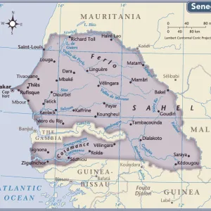
Map of Senegal

![]()
Wall Art and Photo Gifts from Liszt Collection
Map of Senegal
MAP OF SENEGAL
Liszt Collection of nineteenth-century engravings and images to browse and enjoy
Media ID 12974961
© Quint Lox Limited
FEATURES IN THESE COLLECTIONS
> Liszt Collection
> Engravings
> Maps and Charts
> Related Images
EDITORS COMMENTS
This print titled "Map of Senegal" takes us back to the enchanting landscapes and historical richness of nineteenth-century Africa. The meticulously engraved image showcases a beautifully detailed chart, capturing the essence of Senegal's geography, culture, and history. The vintage appeal of this retro-styled artwork transports us to a bygone era when explorers embarked on daring adventures across uncharted territories. The Victorian illustrative technique used in this engraving adds an air of sophistication and elegance to the piece, highlighting its artistic value. As we gaze upon this stunning map, our imagination is ignited with visions of bustling trade routes along the River Senegal, ancient cities steeped in tradition like Dakar and Saint-Louis, and vibrant cultural tapestries woven by diverse ethnic groups such as Wolof, Fulani, Serer, and many others. The Arkheia-printed photograph captures every intricate detail with utmost precision. It serves as a testament to both the skillful craftsmanship involved in creating such engravements during that period and the significance of preserving historical records for future generations. Whether you are an avid collector or simply appreciate art that tells stories from distant lands and times long past, "Map of Senegal" is sure to captivate your senses. Let it transport you on a journey through time while celebrating the rich heritage embedded within this West African nation.
MADE IN AUSTRALIA
Safe Shipping with 30 Day Money Back Guarantee
FREE PERSONALISATION*
We are proud to offer a range of customisation features including Personalised Captions, Color Filters and Picture Zoom Tools
SECURE PAYMENTS
We happily accept a wide range of payment options so you can pay for the things you need in the way that is most convenient for you
* Options may vary by product and licensing agreement. Zoomed Pictures can be adjusted in the Cart.