Home > Africa > Senegal > Maps
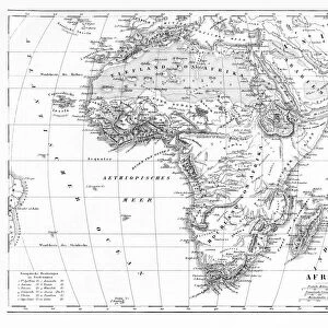
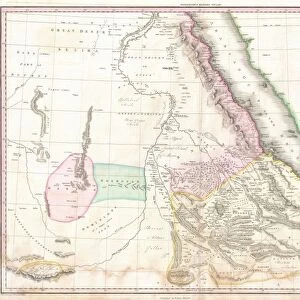
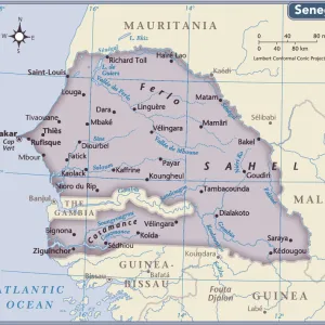
Map of Senegal, Sudan and Guinea, 1896

![]()
Wall Art and Photo Gifts from Liszt Collection
Map of Senegal, Sudan and Guinea, 1896
Liszt Collection of nineteenth-century engravings and images to browse and enjoy
Media ID 12977285
© Quint Lox Limited
1896 Guinea Plan Senegal Sudan Chart
FEATURES IN THESE COLLECTIONS
> Liszt Collection
> Engravings
> Maps and Charts
> Related Images
EDITORS COMMENTS
This print showcases a remarkable piece of history, the "Map of Senegal, Sudan and Guinea, 1896". Transporting us back to the enchanting landscapes of the late nineteenth century, this engraved image is a testament to the illustrative techniques and artistic prowess of that era. The intricate engravement captures every minute detail with precision and skill. The map itself offers a fascinating glimpse into the geographical boundaries and topography of Senegal, Sudan, and Guinea during this period. It serves as an invaluable resource for historians and enthusiasts alike who seek to understand the region's rich cultural heritage. With its retro-styled vintage appeal, this print exudes an air of nostalgia that effortlessly transports us to bygone times. Its Victorian charm adds depth to any space it graces while evoking curiosity about our shared past. Whether displayed in a study or art gallery setting, it becomes an instant conversation starter. Courtesy of Arkheia's Liszt Collection comes yet another masterpiece that seamlessly blends arts and culture with historical significance. This print not only celebrates these three African nations but also pays homage to the illustrators who meticulously crafted such works in days gone by.
MADE IN AUSTRALIA
Safe Shipping with 30 Day Money Back Guarantee
FREE PERSONALISATION*
We are proud to offer a range of customisation features including Personalised Captions, Color Filters and Picture Zoom Tools
SECURE PAYMENTS
We happily accept a wide range of payment options so you can pay for the things you need in the way that is most convenient for you
* Options may vary by product and licensing agreement. Zoomed Pictures can be adjusted in the Cart.