Home > Arts > Artists > K > Johannes van Keulen
Sea chart of the coast of Congo and Angola, Jan Luyken, Johannes van Keulen (I), unknown
, unknown")
![]()
Wall Art and Photo Gifts from Liszt Collection
Sea chart of the coast of Congo and Angola, Jan Luyken, Johannes van Keulen (I), unknown
Sea chart of the coast of Congo and Angola, Jan Luyken, Johannes van Keulen (I), unknown, 1683 - 1799
Liszt Collection of nineteenth-century engravings and images to browse and enjoy
Media ID 12716061
© Quint Lox Limited
1683 1799 Address African Angola Armed Arrows Bull Coast Compass Compasses Congo Conversation Dialogue Focused French Miles Jan Luyken Johannes Van Keulen Merman North Roses Sea Chart Aimed Armed Men Chart Sights
FEATURES IN THESE COLLECTIONS
> Arts
> Artists
> K
> Johannes van Keulen
> Arts
> Artists
> L
> Jan Luyken
> Maps and Charts
> World
EDITORS COMMENTS
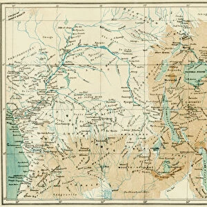
This print showcases a remarkable sea chart of the coast of Congo and Angola, created by Jan Luyken and Johannes van Keulen (I) in the late 17th century. The intricate details on this map transport us back to an era when cartography was both an art form and a vital tool for exploration. The image depicts two men engrossed in conversation as they study the sea chart with great intensity. Their focused gazes are fixed upon the compass roses, indicating cardinal directions, while their hands hold compasses to navigate through uncharted waters. Armed with arrows, these men symbolize the bravery required to venture into unknown territories. Intriguingly, a merman is depicted swimming alongside them, representing mythical creatures that were often associated with unexplored regions of the world during that time period. This inclusion adds an element of mystery and wonder to this already fascinating piece. The map itself reveals detailed coastal features of Congo and Angola, providing valuable geographical knowledge for sailors and explorers alike. French miles are marked along its edges as units of measurement. Quint Lox's skillful photography captures not only the historical significance but also the beauty inherent in this antique sea chart. It serves as a reminder of our enduring fascination with maps as windows into our past adventures and future possibilities.
MADE IN AUSTRALIA
Safe Shipping with 30 Day Money Back Guarantee
FREE PERSONALISATION*
We are proud to offer a range of customisation features including Personalised Captions, Color Filters and Picture Zoom Tools
SECURE PAYMENTS
We happily accept a wide range of payment options so you can pay for the things you need in the way that is most convenient for you
* Options may vary by product and licensing agreement. Zoomed Pictures can be adjusted in the Cart.