Home > North America > United States of America > New York > New York > Maps
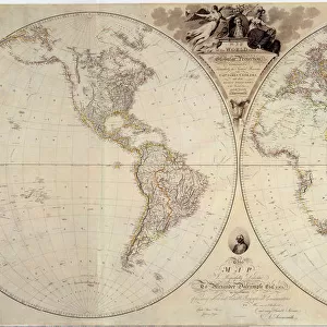
Western Hemisphere map 1856

![]()
Wall Art and Photo Gifts from Fine Art Storehouse
Western Hemisphere map 1856
Colton and Fitchs Modern School Geography by George W. Fitch - New York 1856
Unleash your creativity and transform your space into a visual masterpiece!
THEPALMER
Media ID 13612311
© Roberto A Sanchez
62990 Atlas Backgrounds Dome Earth Globe Man Made Object Globe Navigational Equipment Grunge Grunge Image Technique Hemisphere North America Oceania Pacific Ocean Paper Patina Planet Earth South America Space Stained Textured Effect The Americas West Direction World Map Drawing Art Product Retro Styled
FEATURES IN THESE COLLECTIONS
> Fine Art Storehouse
> The Magical World of Illustration
> Palmer Illustrated Collection
> Fine Art Storehouse
> Map
> Historical Maps
> Maps and Charts
> Early Maps
> Maps and Charts
> World
> North America
> United States of America
> New York
> New York
> Maps
> South America
> Related Images
EDITORS COMMENTS
This print takes us back in time to the year 1856, when cartography was an art form and exploration of the world was at its peak. The Western Hemisphere map featured here is a stunning piece from Colton and Fitch's Modern School Geography by George W. Fitch, published in New York during that era. With its retro styling and engraved image, this antique illustration transports us to a different era. The stained paper and textured effect add an authentic touch, giving it a sense of history and character. As we gaze upon this old-world masterpiece, we are reminded of the vastness of our planet Earth. The map showcases not only North America and South America but also Oceania, highlighting the interconnectedness of these regions across the globe. The Pacific Ocean stretches out before us like an endless sea waiting to be explored. Intriguingly, a dome-like structure hovers above the map as if symbolizing mankind's quest for knowledge about our world. This engraving serves as both a navigational tool and a work of art - drawing us into its intricate details with every glance. The grunge patina adds depth to this vertical composition while evoking nostalgia for times gone by. It reminds us that even within imperfections lies beauty worth cherishing. As we admire this remarkable piece by THEPALMER from Fine Art Storehouse, let it transport you on a journey through time - where maps were hand-drawn works of art that ignited curiosity about our planet's
MADE IN AUSTRALIA
Safe Shipping with 30 Day Money Back Guarantee
FREE PERSONALISATION*
We are proud to offer a range of customisation features including Personalised Captions, Color Filters and Picture Zoom Tools
SECURE PAYMENTS
We happily accept a wide range of payment options so you can pay for the things you need in the way that is most convenient for you
* Options may vary by product and licensing agreement. Zoomed Pictures can be adjusted in the Cart.