Home > Europe > United Kingdom > England > London > Towns > Mill Hill
Daventry NN11 7 Map

![]()
Wall Art and Photo Gifts from Map Marketing
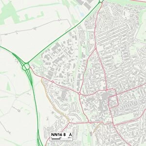
Daventry NN11 7 Map
Postcode Sector Map of Daventry NN11 7
Media ID 19977373
Ash Way Ashby Road Church Road Cross Lane Dark Lane Daventry Eastfields Field View Gould Close Greenway Hazel Croft High Street London Road Maple Close Mill Close Nn11 North Close Old Road Sanders Close School Close South Close Spinney Hill The Green Walnut Close Welton Road Braunston
FEATURES IN THESE COLLECTIONS
> Animals
> Mammals
> Muridae
> Goulds Mouse
> Arts
> Portraits
> Pop art gallery
> Street art portraits
> Europe
> United Kingdom
> England
> London
> Related Images
> Europe
> United Kingdom
> England
> London
> Towns
> Mill Hill
> Map Marketing
> Postcode Sector Maps
> NN - Northampton
> Maps and Charts
> Related Images
MADE IN AUSTRALIA
Safe Shipping with 30 Day Money Back Guarantee
FREE PERSONALISATION*
We are proud to offer a range of customisation features including Personalised Captions, Color Filters and Picture Zoom Tools
SECURE PAYMENTS
We happily accept a wide range of payment options so you can pay for the things you need in the way that is most convenient for you
* Options may vary by product and licensing agreement. Zoomed Pictures can be adjusted in the Cart.