Home > Europe > United Kingdom > England > London > Boroughs > Haringey
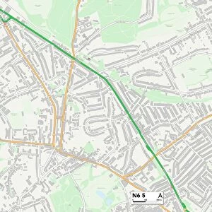
Haringey N8 7 Map

![]()
Wall Art and Photo Gifts from Map Marketing
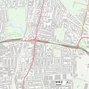
Haringey N8 7 Map
Postcode Sector Map of Haringey N8 7
Media ID 19975619
Baden Road Beechwood Road Birkbeck Road Brook Road Chestnut Avenue Church Lane Clovelly Road Cross Lane Danvers Road Eastfield Road Gisburn Road Glebe Road Haringey Harold Road Hawthorn Road High Street Middle Lane Miles Road Montague Road Newland Road Nightingale Lane Pembroke Road Priory Avenue Priory Road Rectory Gardens Ribblesdale Road South View Road St Marys Road Temple Road Warner Road Hornsey Muswell Hill
FEATURES IN THESE COLLECTIONS
> Animals
> Birds
> Passerines
> Chats And Flycatchers
> Nightingale
> Animals
> Mammals
> Muridae
> House Mouse
> Arts
> Landscape paintings
> Waterfall and river artworks
> River artworks
> Arts
> Portraits
> Pop art gallery
> Street art portraits
> Europe
> United Kingdom
> England
> London
> Boroughs
> Haringey
> Europe
> United Kingdom
> Wales
> Pembrokeshire
> Pembroke
> Map Marketing
> Postcode Sector Maps
> N - London N
> Maps and Charts
> Related Images
MADE IN AUSTRALIA
Safe Shipping with 30 Day Money Back Guarantee
FREE PERSONALISATION*
We are proud to offer a range of customisation features including Personalised Captions, Color Filters and Picture Zoom Tools
SECURE PAYMENTS
We happily accept a wide range of payment options so you can pay for the things you need in the way that is most convenient for you
* Options may vary by product and licensing agreement. Zoomed Pictures can be adjusted in the Cart.