Home > Arts > Artists > B > John Brooks
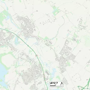
Leicester LE19 4 Map

![]()
Wall Art and Photo Gifts from Map Marketing
Leicester LE19 4 Map
Postcode Sector Map of Leicester LE19 4
Media ID 19973926
Alexander Avenue Almond Road Ashton Drive Beggars Lane Broad Street Brook Street Byron Close Carter Close Chapel Street Cherry Tree Grove Coleridge Drive Cornwall Street Cross Street Drummond Road Forest Road George Street Herrick Close High Street Holyoake Street John Street Keats Close King Street Kipling Drive Kirk Lane Leicester Masefield Avenue Mill Hill Mill Lane Mitchell Road Moores Lane Quarry Lane Rawson Street Shelley Road Sheridan Close Southey Close Stewart Avenue Strawberry Gardens Tay Road The Cross The Nook Townsend Road Tweed Street West Street Enderby Hall Walk
FEATURES IN THESE COLLECTIONS
> Arts
> Artists
> B
> John Brooks
> Arts
> Artists
> C
> John Carter
> Arts
> Artists
> D
> Alexander Drummond
> Arts
> Artists
> D
> John Drummond
> Arts
> Artists
> H
> John Hillers
> Arts
> Artists
> H
> John Hills
> Arts
> Artists
> J
> Jacob Jacobs
> Arts
> Landscape paintings
> Forest and woodland scenes
> Forest artwork
> Arts
> Portraits
> Pop art gallery
> Street art portraits
> Europe
> United Kingdom
> England
> Cornwall
> Ashton
> Map Marketing
> Postcode Sector Maps
> LE - Leicester
MADE IN AUSTRALIA
Safe Shipping with 30 Day Money Back Guarantee
FREE PERSONALISATION*
We are proud to offer a range of customisation features including Personalised Captions, Color Filters and Picture Zoom Tools
SECURE PAYMENTS
We happily accept a wide range of payment options so you can pay for the things you need in the way that is most convenient for you
* Options may vary by product and licensing agreement. Zoomed Pictures can be adjusted in the Cart.