Home > Europe > United Kingdom > England > Manchester > Hollingworth
Manchester M40 3 Map

![]()
Wall Art and Photo Gifts from Map Marketing
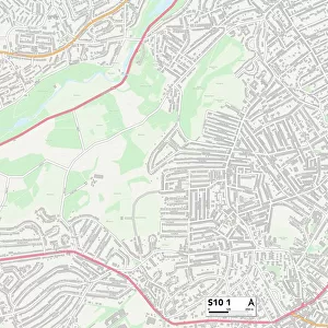
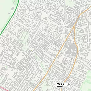
Manchester M40 3 Map
Postcode Sector Map of Manchester M40 3
Media ID 19974238
Anfield Road Annesley Road Belgrave Road Broadway Carnoustie Close Dean Avenue Dean Lane Eastwood Avenue Eastwood Road Elder Grove Greenways Hawthorn Road Hazeldene Road Holly Bank Hoylake Close Lindale Avenue Lindrick Close Manchester Maple Grove Muirfield Close Northfield Road Oakwood Avenue Repton Avenue The Fairway The Links Waters Edge West Avenue Weston Avenue Westwood Avenue Whitegate Close Williams Road Winifred Road Winton Avenue
FEATURES IN THESE COLLECTIONS
> Arts
> Portraits
> Pop art gallery
> Street art portraits
> Europe
> United Kingdom
> England
> Manchester
> Hollingworth
> Europe
> United Kingdom
> England
> Manchester
> Manchester
> Europe
> United Kingdom
> Scotland
> Angus
> Carnoustie
> Map Marketing
> Postcode Sector Maps
> M - Manchester
> Maps and Charts
> Related Images
MADE IN AUSTRALIA
Safe Shipping with 30 Day Money Back Guarantee
FREE PERSONALISATION*
We are proud to offer a range of customisation features including Personalised Captions, Color Filters and Picture Zoom Tools
SECURE PAYMENTS
We happily accept a wide range of payment options so you can pay for the things you need in the way that is most convenient for you
* Options may vary by product and licensing agreement. Zoomed Pictures can be adjusted in the Cart.