Home > Arts > Artists > F > John Field
Monmouthshire NP4 6 Map

![]()
Wall Art and Photo Gifts from Map Marketing
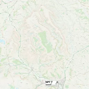
Monmouthshire NP4 6 Map
Postcode Sector Map of Monmouthshire NP4 6
Media ID 19977424
A472 Albion Road Broadway Buller Street Bush Lane Campbell Street Chapel Road Clarence Street Commercial Street Conway Road Crane Street Davis Close East View Estate Road Fairfield Fowler Street George Street Gypsy Lane Hanbury Road High Street Highfield Close Hill Close Hill Street John Street King Street Kitchener Street Limekiln Road Lodge View Malthouse Lane Market Street Monmouthshire Mount Pleasant Mount Pleasant Road Nicholas Street North Road Old School Place Osborne Road Park Road Primrose Lane Prince Street Queen Street Riverside Rosemary Lane School Close School Lane South View St Johns Close Station Street Tan Y Coed The Beeches Valentine Road Wellington Road West End Avenue Bushy Park Capel Street Lower Bridge Street
FEATURES IN THESE COLLECTIONS
> Arts
> Artists
> F
> John Field
> Arts
> Artists
> H
> John Hillers
> Arts
> Artists
> H
> John Hills
> Arts
> Artists
> K
> Nicholas King
> Arts
> Artists
> L
> John Lodge
> Arts
> Artists
> P
> George Prince
> Arts
> Artists
> W
> James Wood
> Arts
> Artists
> W
> John George Wood
> Arts
> Artists
> W
> John Wood
> Arts
> Artists
> W
> Lewis John Wood
> Map Marketing
> Postcode Sector Maps
> NP - Newport
MADE IN AUSTRALIA
Safe Shipping with 30 Day Money Back Guarantee
FREE PERSONALISATION*
We are proud to offer a range of customisation features including Personalised Captions, Color Filters and Picture Zoom Tools
SECURE PAYMENTS
We happily accept a wide range of payment options so you can pay for the things you need in the way that is most convenient for you
* Options may vary by product and licensing agreement. Zoomed Pictures can be adjusted in the Cart.