Home > Europe > United Kingdom > Wales > Flintshire > Buckley
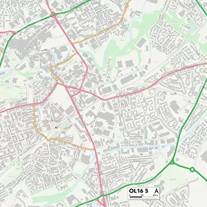
Oldham OL3 6 Map

![]()
Wall Art and Photo Gifts from Map Marketing
Oldham OL3 6 Map
Postcode Sector Map of Oldham OL3 6
Media ID 19977122
Bakers Lane Bankside Close Birch Road Bridge Street Brook Avenue Buckley Street Chapel Street Church Lane Church Road Co Operative Street Court Street Greenbank Avenue Grove Road High Street Lee Street Mill Street New Street Oldham Oldham Road Primrose Avenue Redwood Road Rhodes Avenue School Street Shaws Lane Smithy Lane Spring Street St Marys Gate Station Road Tame Street The Meadows Walkers Close Willow Road Moorgate Street Shaws Water Gate
FEATURES IN THESE COLLECTIONS
> Africa
> Chad
> Related Images
> Animals
> Mammals
> Muridae
> Water Mouse
> Arts
> Portraits
> Pop art gallery
> Street art portraits
> Europe
> United Kingdom
> Wales
> Flintshire
> Buckley
> Map Marketing
> Postcode Sector Maps
> OL - Oldham
> Maps and Charts
> Related Images
MADE IN AUSTRALIA
Safe Shipping with 30 Day Money Back Guarantee
FREE PERSONALISATION*
We are proud to offer a range of customisation features including Personalised Captions, Color Filters and Picture Zoom Tools
SECURE PAYMENTS
We happily accept a wide range of payment options so you can pay for the things you need in the way that is most convenient for you
* Options may vary by product and licensing agreement. Zoomed Pictures can be adjusted in the Cart.