Home > Africa > Chad > Related Images
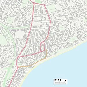
St Edmundsbury IP29 4 Map

![]()
Wall Art and Photo Gifts from Map Marketing
St Edmundsbury IP29 4 Map
Postcode Sector Map of St Edmundsbury IP29 4
Media ID 19971878
Barn Meadow Barnfield Beechcroft Blind Lane Brockley Road Bull Lane Bury Road Chapel Lane Chapel Road Chestnut Crescent Church Close Church Hill Church Road Churchill Close Cooks Lane Cross Green Donkey Lane East Lane Elizabeth Drive Folly Lane Golden Lane Hall Close Kiln Lane Kings Park Lambs Lane Lancaster Close Melford Road Mile End Mill Lane Mill Road Old Lane Old Rectory Lane Old School Road Paddock Way Queens Lane Rectory Grove Rectory Road Rogers Lane Smithy Close Somerton Road St Edmundsbury Stirling Close Straight Road The Green The Row The Street Tudor Close Wellington Close West View Windsor Close Audley End Brockley Rede Somerton
FEATURES IN THESE COLLECTIONS
> Africa
> Chad
> Related Images
> Animals
> Birds
> Charadriiformes
> Little Gull
> Animals
> Birds
> Charadriiformes
> Silver Gull
> Animals
> Farm
> Donkeys
> Related Images
> Animals
> Mammals
> Cricetidae
> Golden Mouse
> Arts
> Artists
> O
> Elizabeth Olds
> Arts
> Artists
> P
> William Page
> Arts
> Artists
> R
> William Rogers
> Arts
> Portraits
> Pop art gallery
> Street art portraits
> Europe
> United Kingdom
> England
> London
> Boroughs
> Harrow
> Map Marketing
> Postcode Sector Maps
> IP - Ipswich
MADE IN AUSTRALIA
Safe Shipping with 30 Day Money Back Guarantee
FREE PERSONALISATION*
We are proud to offer a range of customisation features including Personalised Captions, Color Filters and Picture Zoom Tools
SECURE PAYMENTS
We happily accept a wide range of payment options so you can pay for the things you need in the way that is most convenient for you
* Options may vary by product and licensing agreement. Zoomed Pictures can be adjusted in the Cart.