Home > Europe > United Kingdom > England > Manchester > Hale
Stockport SK4 2 Map

![]()
Wall Art and Photo Gifts from Map Marketing
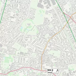
Stockport SK4 2 Map
Postcode Sector Map of Stockport SK4 2
Media ID 19977520
Alexandra Road Blandford Road Brackley Road Bramley Crescent Branksome Road Brantwood Road Brent Road Brighton Road Craig Close Craig Road Dene Court Elizabeth Court Empress Drive Fairholme Road Fairlawn Glenfield Road Gower Road Grantham Road Green Lane Greenside Hale Road Hamilton Crescent Harvey Close Hilary Close June Avenue Kennedy Way Langham Road Lawton Road Leeside Locksley Close Manchester Road Marlborough Drive Masefield Drive May Avenue Meadow Bank Mount Road Newby Road Nursery Road Park Drive Pendennis Road Rosedale Road Rosewood Avenue Sandringham Drive Sherwood Avenue Silverdale Road St Leonards Road St Martins Avenue Stockport Sutton Road Tennyson Close The Glade The Green The Square Valley Road Vaughan Road Warwick Close Winchester Drive Wingate Road Woodside Yew Street Norton Grove Whitefield
FEATURES IN THESE COLLECTIONS
> Arts
> Artists
> C
> Craig Craig
> Arts
> Portraits
> Pop art gallery
> Street art portraits
> Europe
> United Kingdom
> England
> Manchester
> Hale
> Europe
> United Kingdom
> England
> Manchester
> Manchester
> Europe
> United Kingdom
> Scotland
> Stirlingshire
> Dunblane
> Europe
> United Kingdom
> Scotland
> Strathclyde
> Hamilton
> Map Marketing
> Postcode Sector Maps
> SK - Stockport
> Maps and Charts
> Related Images
> North America
> Saint Martin
> Maps
MADE IN AUSTRALIA
Safe Shipping with 30 Day Money Back Guarantee
FREE PERSONALISATION*
We are proud to offer a range of customisation features including Personalised Captions, Color Filters and Picture Zoom Tools
SECURE PAYMENTS
We happily accept a wide range of payment options so you can pay for the things you need in the way that is most convenient for you
* Options may vary by product and licensing agreement. Zoomed Pictures can be adjusted in the Cart.