Home > Architecture > Towers > Churches
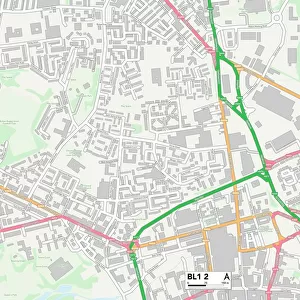
Tonbridge and Malling ME6 5 Map

![]()
Wall Art and Photo Gifts from Map Marketing
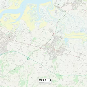
Tonbridge and Malling ME6 5 Map
Postcode Sector Map of Tonbridge and Malling ME6 5
Media ID 19975230
Adams Lane Apple Close Ashfield Close Berry Drive Booth Close Bramley Road Brook Lane Brook Street Cemetery Road Chapel Road Charles Close Church Field Churchfield Constitution Hill Coombe Close Cooper Road Coxs Close Deans Close Delamere Road East Street Edwards Close Ham Hill Hamilton Close High Street Hollow Lane Hook Road Kent Road Lakeside Lee Road Lucas Road Matthews Close May Street Meadow Walk Mill Lane Mill Street Nevill Road Norman Road Orchard Way Oxford Street Pilgrims Close Portland Place Primrose Close Queens Avenue Queens Road Recreation Avenue Rectory Close Roberts Road Roman Road Rookery Close Sandy Lane Simpson Road Stevens Close Taylor Road Tonbridge And Malling Townsend Road Watts Close Whitby Close Wickham Road Willow Close Wingate Close Woodlands Avenue Wyvern Close
FEATURES IN THESE COLLECTIONS
> Architecture
> Towers
> Churches
> Arts
> Artists
> B
> Charles Brooking
> Arts
> Artists
> C
> Robert Cooper
> Arts
> Artists
> H
> Robert Hills
> Arts
> Artists
> R
> Roman Roman
> Arts
> Artists
> S
> Charles Simpson
> Arts
> Portraits
> Pop art gallery
> Street art portraits
> Europe
> United Kingdom
> England
> Kent
> Birling
> Europe
> United Kingdom
> England
> Kent
> Brook Street
> Europe
> United Kingdom
> England
> Kent
> Brook
> Map Marketing
> Postcode Sector Maps
> ME - Rochester
MADE IN AUSTRALIA
Safe Shipping with 30 Day Money Back Guarantee
FREE PERSONALISATION*
We are proud to offer a range of customisation features including Personalised Captions, Color Filters and Picture Zoom Tools
SECURE PAYMENTS
We happily accept a wide range of payment options so you can pay for the things you need in the way that is most convenient for you
* Options may vary by product and licensing agreement. Zoomed Pictures can be adjusted in the Cart.