Home > Animals > Birds > Waterfowl > Geese > Nene
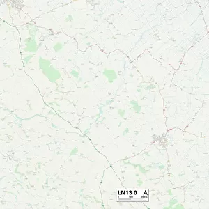
West Lindsey LN1 3 Map

![]()
Wall Art and Photo Gifts from Map Marketing
West Lindsey LN1 3 Map
Postcode Sector Map of West Lindsey LN1 3
Media ID 19973887
Albany Street Anderson Lane Bishops Gate Buchanan Street Burton Road Carisbrooke Close Carlton Street Castle Hill Castle Lane Castle Street Cecil Street Chapel Lane Chestnut Street Clarence Street Clarendon Gardens College Close David Avenue Drury Lane Dunkirk Road Ermine Close Francis Street Garfield Close Gordon Road Gray Street Harrison Place Kingsley Street Mill Road Mill Row Mount Street Nene Road Newport Oakland Close Occupation Road Olive Street Osborne Close Pine Close Queen Elizabeth Road Queen Mary Road Reservoir Street Sanders Close Saxon Street Spire Close Spring Hill Springfield Close St Johns Road St Martins Lane St Michaels Terrace St Nicholas Street Thorpe Avenue Turner Street Union Road Vere Street Welland Road West Lindsey Westgate Williamson Street Wilson Street Windmill View Woburn Avenue Woodburn Close Wordsworth Street Yarborough Road The Pavilion
FEATURES IN THESE COLLECTIONS
> Animals
> Birds
> Waterfowl
> Geese
> Nene
> Arts
> Artists
> H
> John Hillers
> Arts
> Artists
> H
> John Hills
> Arts
> Artists
> M
> David Martin
> Arts
> Artists
> M
> John Martin
> Arts
> Artists
> P
> Francis Place
> Arts
> Artists
> P
> John Pine
> Arts
> Artists
> W
> Wilson Wilson
> Arts
> Portraits
> Pop art gallery
> Street art portraits
> Europe
> France
> Canton
> Aisne
> Map Marketing
> Postcode Sector Maps
> LN - Lincoln
> Map Marketing
> UK Maps
MADE IN AUSTRALIA
Safe Shipping with 30 Day Money Back Guarantee
FREE PERSONALISATION*
We are proud to offer a range of customisation features including Personalised Captions, Color Filters and Picture Zoom Tools
SECURE PAYMENTS
We happily accept a wide range of payment options so you can pay for the things you need in the way that is most convenient for you
* Options may vary by product and licensing agreement. Zoomed Pictures can be adjusted in the Cart.