
Estonia Collection
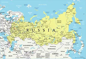
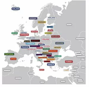
Estonia is a small country located in Northern Europe
Choose a picture from our Estonia Collection for your Wall Art and Photo Gifts
44 items


All Professionally Made to Order for Quick Shipping
-
Estonia Collection
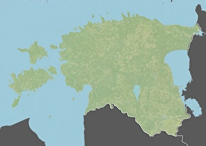
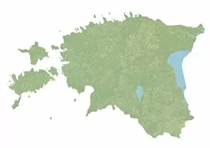
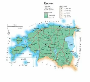
Estonia is a small country located in Northern Europe, bordered by the Baltic Sea to the west and Russia to the east and has a population of approximately 1.3 million people, with its capital city being Tallinn. The country is known for its advanced digital infrastructure and e-government services, which have made it one of the most digitally connected countries in the world. Estonia's economy is primarily driven by technology and manufacturing industries, with major exports including electronics, machinery, and wood products. Its geography features numerous lakes and forests, as well as several islands off its coast in the Baltic Sea.
+
Our beautiful pictures are available as Framed Prints, Photos, Wall Art and Photo Gifts
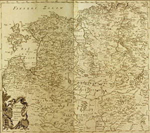
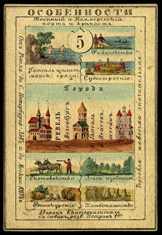
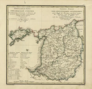
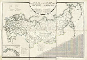
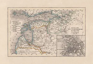
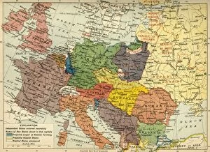
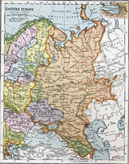
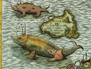
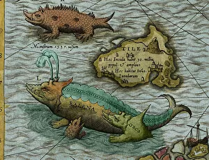
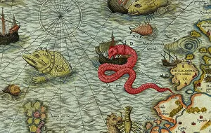
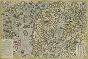
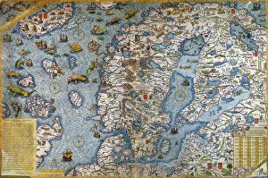
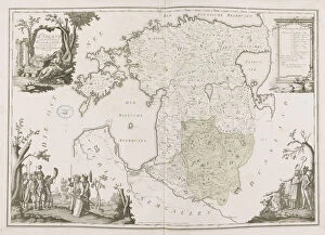
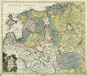
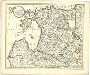
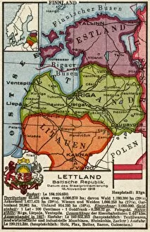
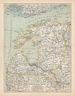
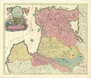
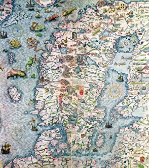
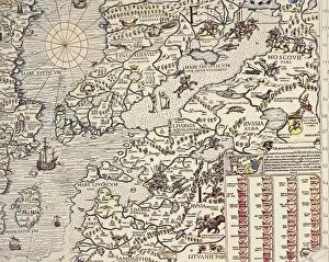
The Estonia collection from Media Storehouse is a fascinating assortment of historical maps and charts related to the Baltic country of Estonia. Our collection includes antique maps dating back to the 16th century, as well as more recent topographical maps and nautical charts. These pieces offer a unique glimpse into the history of Estonia, showcasing its changing borders, cities, and landmarks over time. Our collection features a variety of styles and formats, including hand-drawn illustrations, lithographs, engravings, and digital reproductions. Many of these images are available as wall art or framed prints in various sizes to suit any decor style. Whether you're an avid collector or simply interested in learning more about Estonian history and geography, our collection offers something for everyone. With its stunning visuals and rich historical context, it's sure to be a conversation starter in any home or office setting.
+
What are Estonia (Maps and Charts) art prints?
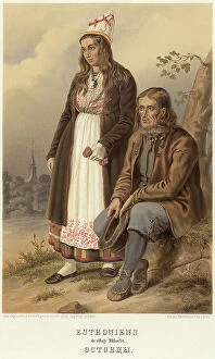
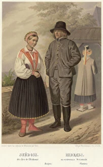
Estonia art prints are high-quality reproductions of vintage maps and charts depicting the geography, topography, and history of Estonia. These prints showcase the intricate details of old cartographic techniques such as hand-drawn illustrations, engravings, and typography. We offer a glimpse into the past while also serving as decorative pieces that can add character to any room. These art prints feature various regions in Estonia including its capital city Tallinn, islands like Saaremaa and Hiiumaa, lakes like Peipsi Järv and Võrtsjärv, rivers like Emajõgi and Pärnu River among others. The historical maps depict political boundaries from different eras ranging from medieval times to modern-day borders. Estonia art prints are perfect for those who appreciate vintage aesthetics or have an interest in Estonian history or geography. They make great gifts for travelers or anyone looking to decorate their home with unique artwork that tells a story about this beautiful country.
+
What Estonia (Maps and Charts) art prints can I buy from Media Storehouse?
We offer a wide range of Estonia maps and charts art prints that you can purchase. These prints are perfect for those who love to explore the beauty of Estonia or want to have a unique piece of artwork in their homes or offices. The collection includes vintage maps, antique charts, and modern designs featuring different regions and cities in Estonia. You can find detailed topographic maps showcasing the country's terrain, as well as nautical charts highlighting its coastline and waterways. Additionally, there are artistic renditions of famous landmarks such as Tallinn's Old Town or Pärnu Beach. Whether you're an avid traveler looking to commemorate your trip to Estonia or simply appreciate beautiful cartography, we have something for everyone. With high-quality printing techniques and a variety of sizes available, these art prints make excellent gifts for friends and family members who share your passion for this fascinating country.
+
How do I buy Estonia (Maps and Charts) art prints?
To buy Estonia art prints from Media Storehouse, you can browse our extensive collection of high-quality images online. Simply search for "Estonia Maps and Charts" in the search bar on our website to view all available options. Once you have found a print that you like, select the size and format that suits your needs. We offer a range of formats including canvas prints, framed prints, and poster prints. You can also choose to have your print delivered as a rolled canvas or unframed poster if you prefer to frame it yourself. Once you have made your selection, add the item to your cart and proceed to checkout. From there, follow the prompts to enter your shipping information and payment details. Buying Estonia art prints from Media Storehouse is an easy process that allows you to enjoy beautiful artwork in your home or office.
+
How much do Estonia (Maps and Charts) art prints cost?
We offer a range of Estonia Maps and Charts art prints that are available for purchase. The cost of these prints may vary depending on the size, quality, and type of print you choose. We have a variety of options to suit different budgets and preferences. Our Estonia Maps and Charts art prints are created using high-quality materials to ensure they last a long time without fading or losing their vibrancy. These prints can be used for personal use in your home or office space as well as for gifting purposes. We take pride in offering our customers affordable prices without compromising on quality. Our selection includes various sizes ranging from small to large so that you can find the perfect fit for your needs. If you're looking for beautiful Estonia Maps and Charts art prints at reasonable prices, look no further than Media Storehouse.
+
How will my Estonia (Maps and Charts) art prints be delivered to me?
Your Estonia art prints will be delivered to you in a safe and secure manner. We take great care in packaging your artwork so that it arrives at your doorstep undamaged. Our standard delivery method is through postal services, which means that your package will be sent directly to the address you provided during checkout. We use high-quality materials for our packaging, including sturdy cardboard boxes and protective wrapping to ensure that your print remains flat and uncreased during transit. Rest assured that we take every precaution necessary to guarantee the safety of your artwork while it's on its way to you. Once your order has been dispatched, we'll send you an email with tracking information so that you can keep tabs on its progress. If there are any issues with delivery or if you have any questions about the process, please don't hesitate to contact us – we're always happy to help.