
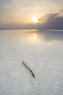
Flat Earth Collection
Flat Earth Maps and Charts refer to the various depictions of the world as a flat surface, rather than a spherical shape
Choose a picture from our Flat Earth Collection for your Wall Art and Photo Gifts
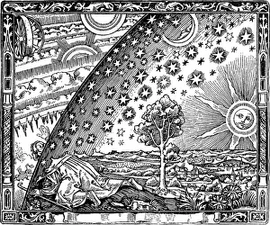
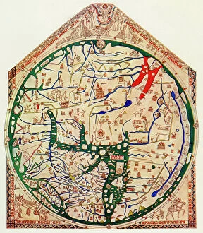
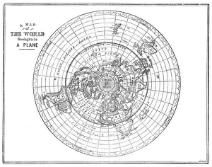
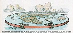
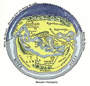
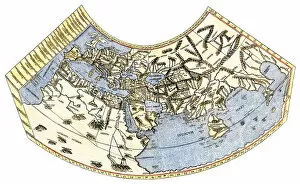
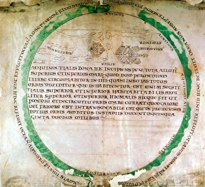
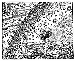
People once believed that the Earth was flat. Below are a few of the maps and charts they created of such a world.
269 items


All Professionally Made to Order for Quick Shipping
-
Flat Earth Collection
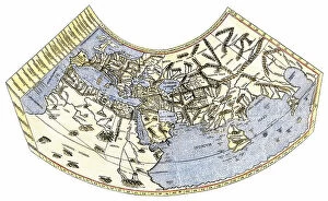
Flat Earth Maps and Charts refer to the various depictions of the world as a flat surface, rather than a spherical shape. This concept is based on the belief that the earth is not round but instead has an edge or boundary. Flat Earth maps typically depict Antarctica as an ice wall surrounding the perimeter of our planet, with all other continents arranged in a circular pattern around it. The idea of a flat earth has been debunked by scientific evidence for centuries, yet some individuals still believe in this theory and use these maps and charts to support their beliefs.
+
Our beautiful pictures are available as Framed Prints, Photos, Wall Art and Photo Gifts
The Flat Earth collection from Media Storehouse offers a unique and intriguing selection of wall art and framed prints that depict the world as a flat plane rather than a spherical globe. Our collection includes vintage maps, charts, and illustrations that were created during a time when many people believed in the flat earth theory. These pieces showcase the various ways in which individuals throughout history have attempted to represent our planet's shape. The artwork in our collection is not only visually stunning but also serves as an interesting historical artifact. It provides insight into how beliefs about the shape of the earth have evolved over time, particularly with advancements in science and technology. Whether you are interested in history or simply looking for something unconventional to decorate your walls, The Flat Earth collection has something for everyone.
+
What are Flat Earth (Maps and Charts) art prints?
Flat Earth art prints are a collection of unique artworks that depict the Flat Earth theory. These prints showcase various maps and charts that illustrate the belief that the earth is not round but rather flat, with its edges surrounded by an ice wall. The artwork features different designs, colors, and styles to cater to various preferences. These art prints are perfect for individuals who believe in this theory or those who find it interesting. They can be used as decorative pieces in homes, offices or public spaces such as libraries or museums. We offer a wide range of Flat Earth art prints created by talented artists from around the world. You can choose their preferred size and framing options to suit their taste and needs. With high-quality printing technology, these artworks are produced on premium quality paper ensuring long-lasting durability while maintaining vibrant colors for years to come.
+
What Flat Earth (Maps and Charts) art prints can I buy from Media Storehouse?
We offer a wide range of Flat Earth art prints, including maps and charts. These prints are available in various sizes and formats, such as canvas, framed or unframed paper prints, and metal wall art. The collection includes vintage-style maps with intricate details that showcase the Flat Earth theory's history. There are also modern designs that feature bold colors and graphics for a contemporary look. The Flat Earth map prints available at Media Storehouse come from different artists worldwide who have created unique interpretations of the theory. Some of these artworks include detailed illustrations of the continents' shapes on a flat plane while others depict an ice wall surrounding the world's edge. Whether you're looking to decorate your home or office space with thought-provoking artwork or seeking inspiration for your next project, we have something for everyone interested in Flat Earth maps and charts art prints.
+
How do I buy Flat Earth (Maps and Charts) art prints?
To purchase Flat Earth art prints from Media Storehouse, you can browse our online collection of maps and charts. Once you have found the print that you would like to purchase, simply add it to your cart and proceed to checkout. During the checkout process, you will be prompted to enter your shipping information and payment details. We offer a variety of sizes for their art prints, so make sure to choose the size that best fits your needs. We also offer different types of paper finishes such as matte or glossy. If you have any questions about purchasing Flat Earth art prints from Media Storehouse, they have a customer service team available to assist you. You can contact them through email or phone during business hours. Once your order has been processed and shipped, expect delivery within the estimated timeframe provided by Media Storehouse. Enjoy displaying your unique piece of Flat Earth artwork in your home or office.
+
How much do Flat Earth (Maps and Charts) art prints cost?
Flat Earth art prints are available for purchase from Media Storehouse. The cost of these prints may vary depending on the size, material, and other factors. However, you can expect to find a range of options that cater to different budgets. We offer high-quality Flat Earth art prints that are perfect for decorating homes or offices. These prints feature stunning designs that showcase the beauty of our planet in unique ways. Whether you're looking for a small print to hang on your wall or a larger one to make a statement, we have something for everyone. With our extensive collection of Flat Earth art prints, you can choose from various styles and themes that suit their preferences. If you're interested in purchasing Flat Earth art prints from Media Storehouse, you'll be able to find affordable options without compromising on quality or style.
+
How will my Flat Earth (Maps and Charts) art prints be delivered to me?
We take pride in delivering your Flat Earth art prints to you with the utmost care. Your order will be carefully packaged and shipped using our trusted delivery partners. We offer a range of shipping options to suit your needs, including standard and express delivery services. Your Flat Earth art prints will be printed on high-quality paper using state-of-the-art printing technology. This ensures that your artwork is vibrant, crisp and true-to-life. Once printed, your artwork will be carefully rolled into a protective tube for safe transportation. When it arrives at your doorstep, simply unroll the print and enjoy its beauty. Whether you're looking to add some unique decor to your home or office space or searching for the perfect gift for someone special, our Flat Earth art prints are sure to impress.