Fraud Blocker Skip to main content

Home > Maps and Charts > Iceland

Iceland Collection

Iceland is a Nordic island country located in the North Atlantic Ocean and has a population of around 364,000 people...

Choose a picture from our Iceland Collection for your Wall Art and Photo Gifts

134 items

Background imageIceland Collection: ICELAND: MAP, 1595. Map of Iceland from a 1595 edition of Abraham Ortelius atlas Theatrum

ICELAND: MAP, 1595. Map of Iceland from a 1595 edition of Abraham Ortelius atlas Theatrum Orbis Terrarum

Background imageIceland Collection: Iceland map, 1800s

Iceland map, 1800s
Map of Iceland, 1870s. Printed color lithograph reproduction of a 19th-century illustratioin

Background imageIceland Collection: Map / Arctic Circle C1880

Map / Arctic Circle C1880
Map of the Arctic Circle with details of explorations

Background imageIceland Collection: Vinland Map, oldest map of Greenland and Northern America areas discovered by Norse

Vinland Map, oldest map of Greenland and Northern America areas discovered by Norse, Vikings during their explorations
Cartography, 15th century. Vinland Map (circa 1440). Oldest map of Greenland and Northern America areas discovered by Norse (Vikings) during their explorations

Background imageIceland Collection: Iceland map 1881

Iceland map 1881
Encyclopedia Britannica 9th Edition Vol XII Philadelphia j.M. Stoddart & Co 1881

Background imageIceland Collection: Topographic map of Europe, lithograph, published in 1897

Topographic map of Europe, lithograph, published in 1897
Topographic map of Europe. Lithograph, published in 1897

Background imageIceland Collection: Map of Iceland, wood engraving, published in 1897

Map of Iceland, wood engraving, published in 1897
Map of Iceland. Wood engraving, published in 1897

Background imageIceland Collection: Map of British Isles, lithograph, lithograph, published in 1876

Map of British Isles, lithograph, lithograph, published in 1876
Map of British Isles. Lithograph, published in 1876

Background imageIceland Collection: Antique Map of Sweden, Norway and Denmark

Antique Map of Sweden, Norway and Denmark
Vintage map of Sweden, Norway and Denmark, from 1894

Background imageIceland Collection: Map / Europe / Iceland 18C

Map / Europe / Iceland 18C
Date: early 18th century

Background imageIceland Collection: Map of Iceland (colour engraving)

Map of Iceland (colour engraving)
STC255317 Map of Iceland (colour engraving) by Blaeu, Willem (1571-1638); Private Collection; The Stapleton Collection; Dutch, out of copyright

Background imageIceland Collection: Island - Iceland map in gray watercolor with native labels

Island - Iceland map in gray watercolor with native labels
Rosana Laiz Blursbyai

Background imageIceland Collection: Ísland - Iceland blank map in gray watercolor

Ísland - Iceland blank map in gray watercolor
Rosana Laiz Blursbyai

Background imageIceland Collection: Proposed route of the North Atlantic Telegraph, 1860. Creator: Unknown

Proposed route of the North Atlantic Telegraph, 1860. Creator: Unknown
Proposed route of the North Atlantic Telegraph, 1860. The concession for the Danish territories on the proposed route was obtained by Colonel Shaffner in 1854

Background imageIceland Collection: Map of Denmark, Iceland, Faroe Islands and Schleswig-Holstein. lithograph, 1893

Map of Denmark, Iceland, Faroe Islands and Schleswig-Holstein. lithograph, 1893
Historical map of Denmark with Iceland, the Faroe Islands and the Prussian province of Schleswig-Holstein. Lithograph, published in 1893

Background imageIceland Collection: Europe Political Map

Europe Political Map
This detailed Europe map covers the whole of the continent of Europe, going east as far as Moscow and south to North Africa

Background imageIceland Collection: Digital illustration of map showing position of Arctic Ocean and surrounding continents

Digital illustration of map showing position of Arctic Ocean and surrounding continents

Background imageIceland Collection: Iceland divided into its districts, engraving by G. Zuliani taken from Tome III of the 'Newest

Iceland divided into its districts, engraving by G. Zuliani taken from Tome III of the "Newest Atlas" published in Venice in 1781 by Antonio Zatta

Background imageIceland Collection: Búða beach, Iceland

Búða beach, Iceland
Jure Kravanja

Background imageIceland Collection: Salford M6 5 Map

Salford M6 5 Map
Postcode Sector Map of Salford M6 5

Background imageIceland Collection: Tower Hamlets E3 2 Map

Tower Hamlets E3 2 Map
Postcode Sector Map of Tower Hamlets E3 2

Background imageIceland Collection: Island - Iceland map in gray watercolor with native labels

Island - Iceland map in gray watercolor with native labels
Rosana Laiz Blursbyai

Background imageIceland Collection: Ísland - Iceland blank map in gray watercolor

Ísland - Iceland blank map in gray watercolor
Rosana Laiz Blursbyai

Background imageIceland Collection: Iceland

Iceland

Background imageIceland Collection: 13881291

13881291

Background imageIceland Collection: Map of America Greenland Ireland and Great Britain 1570 by Sigur Stephanius

Map of America Greenland Ireland and Great Britain 1570 by Sigur Stephanius 1570 North Atlantic map from the Icelandic geographer Sigurd Stephanius, showing part of western Norway ( Norvegia )

Background imageIceland Collection: Canary Islands, from The New Atlas, 1645 (engraving)

Canary Islands, from The New Atlas, 1645 (engraving)
IND113065 Canary Islands, from The New Atlas, 1645 (engraving) by Dutch School, (17th century); Private Collection; Index Fototeca

Background imageIceland Collection: The departure of Leif Ericsson, AD 1000 (litho)

The departure of Leif Ericsson, AD 1000 (litho)
7184125 The departure of Leif Ericsson, AD 1000 (litho) by McDowell, William John Patton (1889-1950); Private Collection; (add.info.: The departure of Leif Ericsson, AD 1000)

Background imageIceland Collection: Volcano Crater Volcano Off, 1853 (colour litho)

Volcano Crater Volcano Off, 1853 (colour litho)
6203314 Volcano Crater Volcano Off, 1853 (colour litho) by Italian School, (19th century); (add.info.: VOLCANO " Volcano crater turned off. No land in Europe abounds more volcanoes than Italy)

Background imageIceland Collection: Frithjof in the hall of King Ring (engraving)

Frithjof in the hall of King Ring (engraving)
7147826 Frithjof in the hall of King Ring (engraving) by Leeke, Ferdinand (1859-1923); Private Collection; (add.info.: Frithjof in the hall of King Ring)

Background imageIceland Collection: Le Vocabulaire Illustre: Islandais; Icelanders; Islander (engraving)

Le Vocabulaire Illustre: Islandais; Icelanders; Islander (engraving)
7196419 Le Vocabulaire Illustre: Islandais; Icelanders; Islander (engraving) by European School, (19th century); Private Collection; (add.info.: Islandais; Icelanders; Islander)

Background imageIceland Collection: Norwegians landing on Iceland, 872 (engraving)

Norwegians landing on Iceland, 872 (engraving)
7147850 Norwegians landing on Iceland, 872 (engraving) by Wergeland, Oscar Arnold (1844-1910); Private Collection; (add.info.: Norwegians landing on Iceland, 872)

Background imageIceland Collection: Iceland, 1595 (engraving, 1596)

Iceland, 1595 (engraving, 1596)
LRI4716639 Iceland, 1595 (engraving, 1596) by Mercator, Gerardus (1512-94); Private Collection; (add.info.: Islandia, 1595)

Background imageIceland Collection: Iceland divided into its districts, engraving by G. Zuliani taken from Tome III of the 'Newest

Iceland divided into its districts, engraving by G. Zuliani taken from Tome III of the "Newest
3572577 Iceland divided into its districts, engraving by G. Zuliani taken from Tome III of the " Newest Atlas" published in Venice in 1781 by Antonio Zatta, Private Collection by Zuliani

Background imageIceland Collection: Hudson Bay, Land of Labrador and Greenland with the adjacent islands, engraving by G

Hudson Bay, Land of Labrador and Greenland with the adjacent islands, engraving by G
3572548 Hudson Bay, Land of Labrador and Greenland with the adjacent islands, engraving by G. Zuliani taken from Tome I of the " Newest Atlas" published in Venice in 1778 by Antonio Zatta

Background imageIceland Collection: Southern Scotland divided into its counties, engraving by G. Zuliani taken from Tome I of

Southern Scotland divided into its counties, engraving by G. Zuliani taken from Tome I of the "Newest
3572546 Southern Scotland divided into its counties, engraving by G. Zuliani taken from Tome I of the " Newest Atlas" published in Venice in 1779 by Antonio Zatta

Background imageIceland Collection: Part of the Kingdom of Ireland, that is, the provinces of Ulster and Leinster, engraving by G

Part of the Kingdom of Ireland, that is, the provinces of Ulster and Leinster, engraving by G
3572543 Part of the Kingdom of Ireland, that is, the provinces of Ulster and Leinster, engraving by G. Zuliani taken from Tome I of the " Newest Atlas" published in Venice in 1778 by

Background imageIceland Collection: The islands of Newfoundland and Cape Breton, engraving by G. Zuliani taken from Tome I of

The islands of Newfoundland and Cape Breton, engraving by G. Zuliani taken from Tome I of the "Newest
3572549 The islands of Newfoundland and Cape Breton, engraving by G. Zuliani taken from Tome I of the " Newest Atlas" published in Venice in 1778 by Antonio Zatta

Background imageIceland Collection: A Nautical Map, detail of the Canary Islands, 1564 (colour litho)

A Nautical Map, detail of the Canary Islands, 1564 (colour litho)
955467 A Nautical Map, detail of the Canary Islands, 1564 (colour litho) by Maggiolo, Giacomo (16th Century); Biblioteca Civica Bertoliana, Vicenza, Italy; Alinari

Background imageIceland Collection: Ms. 1288 fol. 1 The Polar Aurora, from a Collection of Dutch Marine Maps

Ms. 1288 fol. 1 The Polar Aurora, from a Collection of Dutch Marine Maps
BIF271726 Ms. 1288 fol. 1 The Polar Aurora, from a Collection of Dutch Marine Maps (engraving) by Gerritsz, Hessel (1581-1632); Bibliotheque de l Institut de France, Paris

Background imageIceland Collection: Septentrionalium terrarum descriptio, map of the Arctic, 1595 (engraving)

Septentrionalium terrarum descriptio, map of the Arctic, 1595 (engraving)
STC126924 Septentrionalium terrarum descriptio, map of the Arctic, 1595 (engraving) by Mercator, Gerardus (1512-94); Private Collection; (add.info)

Background imageIceland Collection: Map of Iceland and Northern British Isles, in the North Sea, 1704 (etching, 1717)

Map of Iceland and Northern British Isles, in the North Sea, 1704 (etching, 1717)
LRI4711200 Map of Iceland and Northern British Isles, in the North Sea, 1704 (etching, 1717) by Nolin, Jean-Baptiste (c.1657-1708); Private Collection; (add.info)

Background imageIceland Collection: Hekla volcano in Iceland. Atlas of Abraham Ortelius, Amsterdam 1588

Hekla volcano in Iceland. Atlas of Abraham Ortelius, Amsterdam 1588
GIA4745313 Hekla volcano in Iceland. Atlas of Abraham Ortelius, Amsterdam 1588. by Ortelius, Abraham (1527-98); Private Collection; (add.info.: Hekla volcano in Iceland)

Background imageIceland Collection: Map of Iceland and representation of its inhabitants - in '

Map of Iceland and representation of its inhabitants - in "
GIA4764790 Map of Iceland and representation of its inhabitants - in " Map of modern itineraries and travels", 1613

Background imageIceland Collection: Chart of Betrothal Bay, shewing the Male Route to Churchdoor (colour litho)

Chart of Betrothal Bay, shewing the Male Route to Churchdoor (colour litho)
6032849 Chart of Betrothal Bay, shewing the Male Route to Churchdoor (colour litho) by English School, (19th century); Private Collection; (add.info.: Chart of Betrothal Bay)

Background imageIceland Collection: Ms. 1288 fol. 1 The Polar Aurora, detail of England, Ireland and Norway

Ms. 1288 fol. 1 The Polar Aurora, detail of England, Ireland and Norway
BIF271727 Ms. 1288 fol. 1 The Polar Aurora, detail of England, Ireland and Norway, from a Collection of Dutch Marine Maps (engraving) by Gerritsz

Background imageIceland Collection: Map of Cuba, c1500 (engraving)

Map of Cuba, c1500 (engraving)
3647379 Map of Cuba, c1500 (engraving) by German School, (19th century); Private Collection; (add.info.: Map of Cuba, c1500)

Background imageIceland Collection: Island of Minorca and the plan of the port and the city of Mahon and its Forts, engraving by G

Island of Minorca and the plan of the port and the city of Mahon and its Forts, engraving by G
3572542 Island of Minorca and the plan of the port and the city of Mahon and its Forts, engraving by G. Zuliani taken from Tome I of the " Newest Atlas" published in Venice in 1778 by


All Professionally Made to Order for Quick Shipping


-

Iceland Collection

Iceland is a Nordic island country located in the North Atlantic Ocean and has a population of around 364,000 people and covers an area of approximately 103,000 square kilometers. The country is known for its stunning natural landscapes including glaciers, hot springs, geysers, and volcanoes. Iceland's economy relies heavily on fishing and tourism industries. Reykjavik is the capital city and largest urban center in Iceland with a population of over 130,000 people. The official language spoken is Icelandic while English is widely spoken as well. Overall, it offers visitors unique experiences with its breathtaking scenery and rich cultural heritage.
+

Our beautiful pictures are available as Framed Prints, Photos, Wall Art and Photo Gifts

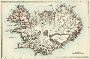
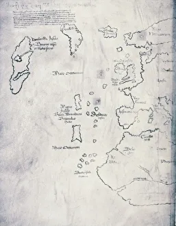
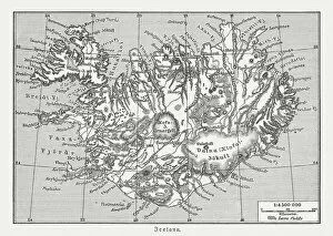
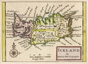
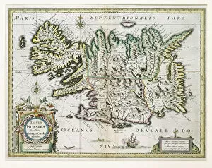
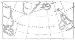
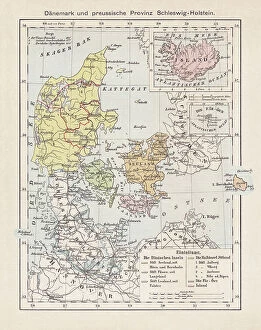
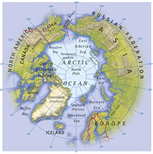
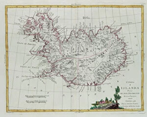
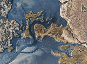
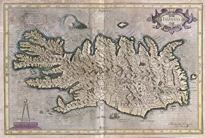
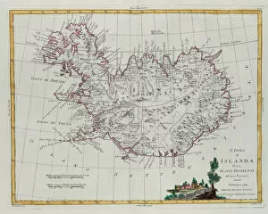
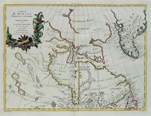
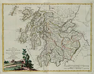
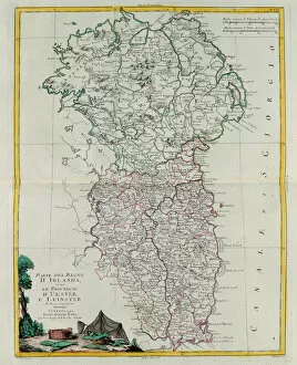
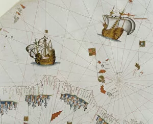
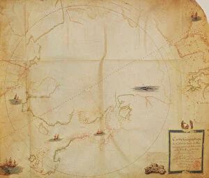
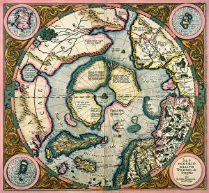
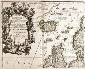
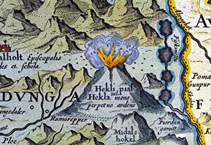
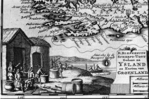
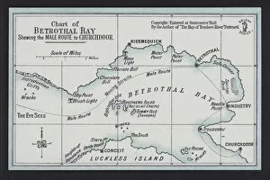
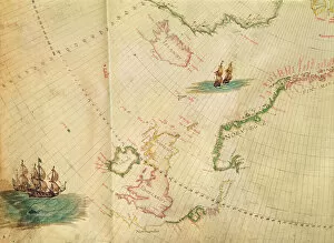
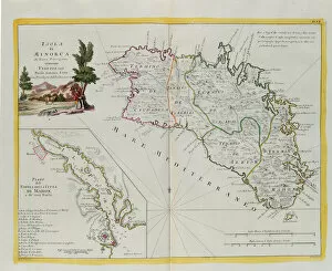
The Iceland collection from Media Storehouse is a stunning assortment of wall art and framed prints that showcase the beauty of Iceland's landscapes. Our collection features an array of maps and charts that depict the country's topography, including its glaciers, mountains, rivers, and coastlines. These pieces are perfect for anyone who loves geography or has an interest in exploring Iceland's natural wonders. Each print is expertly crafted using high-quality materials to ensure longevity and durability. The vibrant colors used in these prints capture the essence of Iceland's unique landscape while adding a touch of sophistication to any room they're displayed in. Whether you're looking to decorate your home or office space with beautiful artwork inspired by nature, the Iceland collection from Media Storehouse offers something for everyone. With its breathtaking imagery and exceptional quality, our collection is sure to impress even the most discerning art enthusiasts.
+

What are Iceland (Maps and Charts) art prints?

Iceland art prints are a collection of high-quality, visually stunning prints that depict various maps and charts of Iceland. These prints showcase the unique geography, topography, and landmarks of Iceland in intricate detail, making them perfect for anyone who loves this beautiful country. These art prints come in a variety of sizes to suit any space or decor style. They are printed on premium quality paper using state-of-the-art printing technology to ensure that every detail is captured with clarity and precision. Whether you're looking for a striking piece to add to your home or office decor or want to give someone special a thoughtful gift that celebrates their love for Iceland, these art prints are an excellent choice. With their exceptional quality and attention to detail, they are sure to impress even the most discerning art lover.
+

What Iceland (Maps and Charts) art prints can I buy from Media Storehouse?

We offer a wide range of Iceland art prints, including maps and charts. These prints showcase the stunning natural beauty of Iceland's landscapes, from its glaciers and waterfalls to its rugged coastlines and volcanic terrain. Some popular options include detailed topographical maps that highlight the country's unique geography, as well as vintage nautical charts that capture the spirit of exploration and adventure. In addition to traditional paper prints, Media Storehouse also offers a variety of other formats for these images, such as canvas prints or framed wall art. Whether you're looking for a bold statement piece or something more subtle to complement your home decor, there are plenty of options available to suit your style and taste. If you're interested in adding some beautiful Icelandic scenery to your walls, Media Storehouse is definitely worth checking out.
+

How do I buy Iceland (Maps and Charts) art prints?

To purchase Iceland art prints from Media Storehouse, you can browse our extensive collection of high-quality prints online. Simply search for the specific print or category you are interested in, such as "Iceland maps" or "Iceland charts," and select the size and format that best suits your needs. Once you have chosen your desired print, add it to your cart and proceed to checkout. You will be prompted to enter your shipping information and payment details before finalizing your order. We offer a range of printing options, including canvas prints, framed prints, and unframed prints on high-quality paper. We also offer a variety of sizes to choose from so that you can find the perfect fit for any space. Whether you're looking for a unique piece of wall art or a gift for an Iceland enthusiast, we have something to suit every taste and budget.
+

How much do Iceland (Maps and Charts) art prints cost?

We offer a wide range of Iceland art prints at varying prices. Our collection includes high-quality prints that capture the beauty of Iceland's landscapes, landmarks, and culture. The cost of each print depends on several factors such as size, framing options, and printing materials. We use premium quality paper to ensure that our prints are long-lasting and retain their vibrant colors for years to come. Whether you're looking for a small print to add some character to your home or office space or a large statement piece for your living room wall, we have something for everyone. Our Iceland art prints make great gifts for friends and family who love travel or appreciate beautiful artwork. We take pride in offering affordable yet stunning pieces that will enhance any interior design style. Browse our collection today to find the perfect print for you.
+

How will my Iceland (Maps and Charts) art prints be delivered to me?

We take great care in ensuring that your Iceland art prints are delivered to you safely and securely. Our team of experienced professionals use high-quality packaging materials to protect your artwork from any damage during transit. Depending on the size and quantity of your order, we may use a variety of delivery methods including standard mail or courier services. Once your order has been processed, you will receive an email confirmation with tracking information so that you can keep track of its progress. We understand how important it is for our customers to receive their orders as quickly as possible, which is why we aim to dispatch all orders within 24 hours. We pride ourselves on providing excellent customer service and ensuring that every aspect of your experience with us is positive. If you have any questions or concerns about the delivery of your Iceland art prints, please do not hesitate to contact us – our friendly team will be more than happy to help.