
Malta Collection
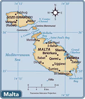
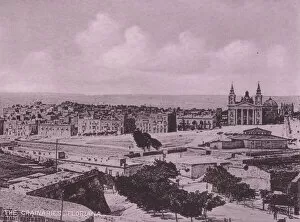
Malta is a small island nation located in the Mediterranean Sea, south of Italy. It consists of three main islands: Malta, Gozo and Comino
Choose a picture from our Malta Collection for your Wall Art and Photo Gifts
103 items


All Professionally Made to Order for Quick Shipping
-
Malta Collection
Malta is a small island nation located in the Mediterranean Sea, south of Italy. It consists of three main islands: Malta, Gozo and Comino. The country has a rich history dating back to prehistoric times and has been ruled by various civilizations including the Phoenicians, Romans, Arabs and British. Today, Malta is an independent republic with a population of around 500,000 people. Its economy relies heavily on tourism and financial services. Maps and charts are essential tools for navigating the Maltese archipelago as well as for studying its geography and history. They provide valuable information about landmarks, topography, climate patterns and more.
+
Our beautiful pictures are available as Framed Prints, Photos, Wall Art and Photo Gifts
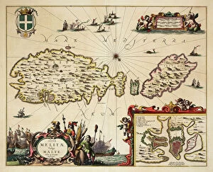
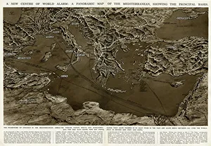
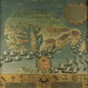
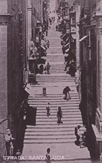
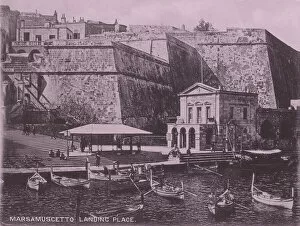
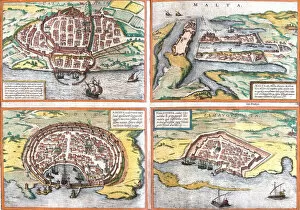
The Malta collection from Media Storehouse is a stunning compilation of vintage maps and charts that depict the Maltese islands. Our collection includes a range of maps, from ancient hand-drawn pieces to more modern printed versions, all showcasing the unique geography and history of Malta. These prints are perfect for anyone interested in cartography or the rich cultural heritage of this Mediterranean archipelago. Our collection features various styles, including nautical charts used by sailors to navigate around the island's shores. These intricate designs highlight important landmarks such as harbors, lighthouses, and underwater topography. Additionally, there are also detailed street maps that showcase urban areas like Valletta with its narrow streets and historic buildings. Our collection provides an excellent opportunity to explore Malta's past through beautiful artwork that captures its unique character. Whether you're looking for wall art for your home or office space or just want to admire these historical documents' beauty - our collection has something for everyone.
+
What are Malta (Maps and Charts) art prints?
Malta art prints are high-quality reproductions of vintage maps and charts depicting the Maltese archipelago. These art prints showcase the intricate details of Malta's geography, including its coastlines, cities, towns, and landmarks. The maps and charts featured in these art prints date back to different periods in history, providing a glimpse into how Malta has evolved over time. These art prints are perfect for those who appreciate historical artifacts or have an interest in cartography. They can be used to decorate homes or offices with a unique touch that reflects one's appreciation for history and culture. Additionally, they make great gifts for friends or family members who share similar interests. We offer a wide range of Malta art prints that cater to various preferences. Each print is made using premium materials that ensure longevity so that you can enjoy your artwork for years to come.
+
What Malta (Maps and Charts) art prints can I buy from Media Storehouse?
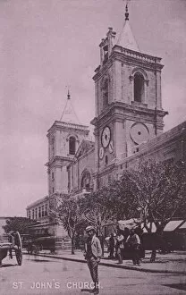
We offer a wide range of Malta maps and charts art prints that are perfect for those who love history, geography, or simply want to decorate their homes with unique artwork. These prints feature detailed and accurate depictions of the Maltese islands, including their coastlines, cities, towns, and landmarks. Some of the popular Malta maps and charts art prints available at Media Storehouse include vintage maps from different eras such as 17th century maps by Blaeu and Coronelli's 1696 map of Malta. There are also more recent topographical surveys like the Admiralty Chart which is an official nautical chart produced by the UK Hydrographic Office. In addition to these historical pieces, there are also contemporary designs featuring modern typography styles or artistic interpretations of famous landmarks like St John's Co-Cathedral in Valletta. Whether you're looking for something classic or trendy, we have plenty of options to choose from when it comes to Malta maps and charts art prints.
+
How do I buy Malta (Maps and Charts) art prints?
To purchase Malta maps and charts art prints from Media Storehouse, you can browse our extensive collection of high-quality images online. Once you have found the print that you would like to buy, simply add it to your cart and proceed to checkout. You will be prompted to enter your shipping and payment information before completing your order. We offer a variety of sizes for their prints, so make sure to select the size that best fits your needs. We also offer framing options if you would like your print ready-to-hang upon arrival. Their selection includes vintage maps as well as more modern designs, so there is something for every taste and style preference. Whether you are looking for a unique piece of wall art or a gift for someone who loves Malta, we have plenty of options available at affordable prices.
+
How much do Malta (Maps and Charts) art prints cost?
We offer a wide range of Malta art prints at varying prices to suit different budgets. Our collection includes high-quality reproductions of antique maps and charts depicting the Maltese islands from various periods in history. These prints are perfect for anyone interested in geography, history or simply looking to add some unique artwork to their home or office. Our Malta art prints come in a variety of sizes and finishes, including framed and unframed options. We use only the highest quality materials to ensure that our customers receive a product that is both beautiful and long-lasting. Whether you're looking for a small print to hang on your wall or a large statement piece, we have something for everyone. Our prices vary depending on the size and finish of each print, so please visit our website or contact us directly for more information about pricing.
+
How will my Malta (Maps and Charts) art prints be delivered to me?
Your Malta art prints will be delivered to you in a secure and professional manner. We take great care in packaging your prints to ensure they arrive at your doorstep in pristine condition. Our standard delivery method is through trusted courier services, who will handle your package with the utmost care during transit. We use high-quality materials for our packaging, including sturdy cardboard tubes or flat-pack boxes depending on the size of your print. Your artwork will be carefully rolled or flat-packed to prevent any damage during shipping. Once dispatched, we'll provide you with a tracking number so that you can monitor the progress of your delivery online. If there are any issues with delivery, our customer service team is always available to assist you. At Media Storehouse, we're committed to providing exceptional service and quality products. You can trust us to deliver your Malta art prints safely and efficiently straight to your door.