Home > North America > United States of America > New York > New York > Maps
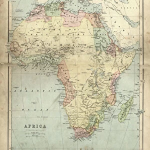
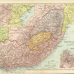
Africa map of 1869

![]()
Wall Art and Photo Gifts from Fine Art Storehouse
Africa map of 1869
Cornells Grammar School Geography By S.S. Cornell - New York 1869
Unleash your creativity and transform your space into a visual masterpiece!
THEPALMER
Media ID 18106805
© 2014 Roberto Adrian Photography
FEATURES IN THESE COLLECTIONS
> Africa
> Related Images
> Fine Art Storehouse
> Map
> Historical Maps
> Maps and Charts
> Early Maps
> North America
> United States of America
> New York
> New York
> Maps
EDITORS COMMENTS
In this photo print, we are transported back to the year 1869, where we encounter a remarkable artifact from the past - an Africa map. This particular map was featured in "Cornells Grammar School Geography" by S. S. Cornell, published in New York during that time. As our eyes wander across the intricate details of this vintage cartographic masterpiece, we can't help but marvel at the craftsmanship and precision employed by its creator. The map showcases a continent teeming with mystery and untamed beauty, inviting us to embark on a journey through its vast landscapes and diverse cultures. Every contour line and delicate stroke on this aged paper tells a story of exploration and discovery. It serves as a testament to humanity's relentless pursuit of knowledge about our world. From the mighty Nile River snaking its way through Egypt to the expansive Sahara Desert stretching across Northern Africa, each feature is meticulously depicted with utmost accuracy. This print allows us to appreciate not only the historical significance of this piece but also its artistic value. The sepia tones lend it an air of nostalgia, transporting us back in time when explorers set out into uncharted territories armed with nothing but their curiosity and determination. "TheAfrica Map of 1869" offers us a glimpse into an era long gone yet forever imprinted on these fragile pages. It reminds us that even amidst modern advancements, there is still much wisdom to be gained from studying our past – for understanding history is key to shaping our future.
MADE IN AUSTRALIA
Safe Shipping with 30 Day Money Back Guarantee
FREE PERSONALISATION*
We are proud to offer a range of customisation features including Personalised Captions, Color Filters and Picture Zoom Tools
SECURE PAYMENTS
We happily accept a wide range of payment options so you can pay for the things you need in the way that is most convenient for you
* Options may vary by product and licensing agreement. Zoomed Pictures can be adjusted in the Cart.