Home > North America > United States of America > New York > New York > Maps
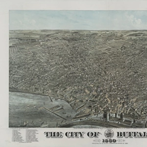
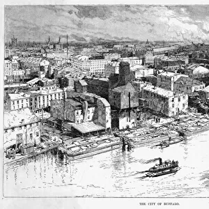
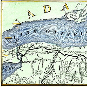
Buffalo city map 1893

![]()
Wall Art and Photo Gifts from Fine Art Storehouse
Buffalo city map 1893
Johnsonas Universal Cyclopedia - Charles Kendall - New York 1893
Unleash your creativity and transform your space into a visual masterpiece!
THEPALMER
Media ID 14756558
© This content is subject to copyright
FEATURES IN THESE COLLECTIONS
> Fine Art Storehouse
> Map
> Historical Maps
> Fine Art Storehouse
> Map
> USA Maps
> Maps and Charts
> Early Maps
> North America
> United States of America
> Maps
> North America
> United States of America
> New York
> Buffalo
> North America
> United States of America
> New York
> New York
> Maps
EDITORS COMMENTS
In this print titled "Buffalo City Map 1893" we are transported back in time to the bustling streets of Buffalo, New York. The map, sourced from Johnson's Universal Cyclopedia by Charles Kendall in 1893, offers a fascinating glimpse into the city's rich history and urban development. As our eyes wander across the intricate details of this vintage map, we can't help but marvel at the meticulous craftsmanship that went into its creation. Every street and building is meticulously labeled, providing us with a comprehensive understanding of Buffalo's layout during that era. The image captures an important moment in time when Buffalo was rapidly growing as a major industrial center. With its strategic location on Lake Erie and proximity to Niagara Falls, it became a hub for trade and commerce. This map serves as both a historical artifact and a testament to the city's vibrant past. "The Palmer" an esteemed artist associated with Fine Art Storehouse, has expertly reproduced this remarkable piece of history through their masterful printing technique. Their attention to detail ensures that every line and curve is faithfully preserved, allowing us to appreciate the beauty of this antique map from the comfort of our own homes. Whether you're an avid historian or simply captivated by old-world charm, "Buffalo City Map 1893" will transport you back in time while adding a touch of elegance to any space it graces.
MADE IN AUSTRALIA
Safe Shipping with 30 Day Money Back Guarantee
FREE PERSONALISATION*
We are proud to offer a range of customisation features including Personalised Captions, Color Filters and Picture Zoom Tools
SECURE PAYMENTS
We happily accept a wide range of payment options so you can pay for the things you need in the way that is most convenient for you
* Options may vary by product and licensing agreement. Zoomed Pictures can be adjusted in the Cart.